Estimated Value: $380,000 - $397,000
4
Beds
3
Baths
2,342
Sq Ft
$166/Sq Ft
Est. Value
About This Home
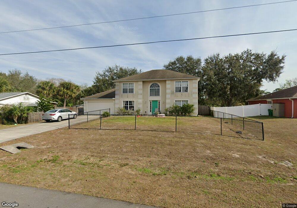
This home is located at 6455 Ainsworth Rd, Cocoa, FL 32927 and is currently estimated at $388,978, approximately $166 per square foot. 6455 Ainsworth Rd is a home located in Brevard County with nearby schools including Enterprise Elementary School, Space Coast Junior/Senior High School, and East Atlantic Prep of Brevard County.
Ownership History
Date
Name
Owned For
Owner Type
Purchase Details
Closed on
Jun 14, 2007
Sold by
Maronda Homes Inc Of Florida
Bought by
Macon David C and Macon Shelley J
Current Estimated Value
Home Financials for this Owner
Home Financials are based on the most recent Mortgage that was taken out on this home.
Original Mortgage
$76,380
Interest Rate
6.16%
Purchase Details
Closed on
Aug 18, 2005
Sold by
Philogene Oramil Joseph
Bought by
Maronda Homes Inc Of Florida
Purchase Details
Closed on
Jul 25, 1997
Sold by
Nationsbank Fl N A
Bought by
Philogene Oramil Joseph
Create a Home Valuation Report for This Property
The Home Valuation Report is an in-depth analysis detailing your home's value as well as a comparison with similar homes in the area
Home Values in the Area
Average Home Value in this Area
Purchase History
| Date | Buyer | Sale Price | Title Company |
|---|---|---|---|
| Macon David C | $201,000 | Adams Title Inc | |
| Maronda Homes Inc Of Florida | $68,500 | Adams Title Inc | |
| Philogene Oramil Joseph | $14,900 | -- |
Source: Public Records
Mortgage History
| Date | Status | Borrower | Loan Amount |
|---|---|---|---|
| Closed | Macon David C | $76,380 |
Source: Public Records
Tax History Compared to Growth
Tax History
| Year | Tax Paid | Tax Assessment Tax Assessment Total Assessment is a certain percentage of the fair market value that is determined by local assessors to be the total taxable value of land and additions on the property. | Land | Improvement |
|---|---|---|---|---|
| 2025 | $1,917 | $132,870 | -- | -- |
| 2024 | $1,874 | $129,130 | -- | -- |
| 2023 | $1,874 | $125,370 | $0 | $0 |
| 2022 | $1,755 | $121,720 | $0 | $0 |
| 2021 | $1,763 | $118,180 | $0 | $0 |
| 2020 | $1,675 | $116,550 | $0 | $0 |
| 2019 | $1,612 | $113,930 | $0 | $0 |
| 2018 | $1,606 | $111,810 | $0 | $0 |
| 2017 | $1,601 | $109,520 | $0 | $0 |
| 2016 | $1,610 | $107,270 | $16,200 | $91,070 |
| 2015 | $1,635 | $106,530 | $13,500 | $93,030 |
| 2014 | $1,639 | $105,690 | $9,900 | $95,790 |
Source: Public Records
Map
Nearby Homes
- 6365 Homestead Ave
- 23-35-21-JX-B-2 Aruin St
- 6545 Addie Ave
- 5715 Fairbridge St
- 4650 N Highway 1 Hwy
- 6309 Alleghany Ave
- 6665 Addie Ave
- 5575 Curtis Blvd
- 6105 Banyan St
- 6010 Fay Blvd
- 6643 Emil Ave
- 6581 Bancroft Ave
- 6115 Allmont St
- 6003 Gilson
- 6198 Dees Rd
- 5460 Holden Rd
- 5940 Flamingo Ave
- 6295 Banyan St
- 6615 Dock Ave
- 6017 Flamingo Ave
- 6465 Ainsworth Rd
- 6445 Ainsworth Rd
- 6475 Ainsworth Rd
- 6435 Ainsworth Rd
- 6450 Ainsworth Rd
- 6440 Ainsworth
- 6470 Ainsworth Rd
- 6485 Ainsworth Rd
- 6425 Ainsworth Rd
- 6430 Ainsworth Rd
- 6480 Ainsworth Rd
- 6483 Bamboo Ave
- 0 Aruin St
- 6459 Bamboo Ave
- 6420 Ainsworth Rd
- 6495 Bamboo Ave
- 6490 Ainsworth Rd
- 6495 Ainsworth Rd
- 6447 Bamboo Ave
- 6507 Bamboo Ave