
Seller's Agent in 2025
Susan Stier
Windermere Realty Trust
(503) 701-0066
1 in this area
27 Total Sales
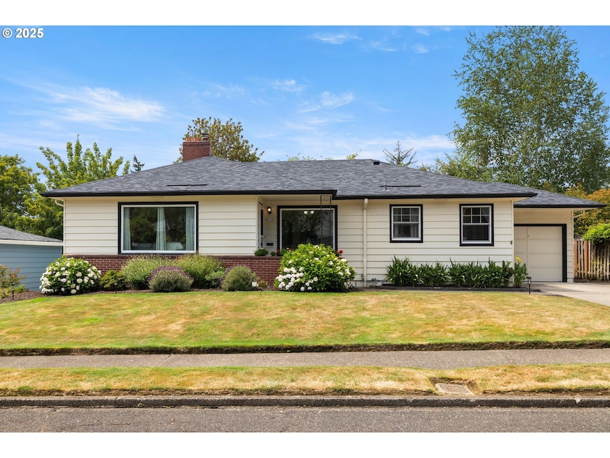


Charming Cottage-Style Ranch Home Near Gabriel Park, MJCC, Multnomah Village and Hillsdale. Nestled just blocks from Gabriel Park and the vibrant Multnomah Village, this delightful cottage-style ranch offers the perfect blend of comfort, charm, and convenience. The flexible floor plan features a spacious main level with hardwood floors, a beautifully remodeled kitchen with quartz countertops, and updated appliances.Downstairs, you’ll find a second partial kitchen and entertainment area—ideal for guests or hosting events. Abundant storage throughout, along with bonus spaces, ensures there’s room for everything.The private backyard is a serene retreat, offering plenty of space for play, relaxation, and entertaining. Beautiful gardens add to the outdoor beauty, while multiple patios provide perfect spots to unwind.Recent upgrades, including Marvin fiberglass windows, a composition roof installed in Jan 2025, and updated systems, mean that every surface of this home has been thoughtfully updated for ease and comfort.With 4 bedrooms and a fantastic location just steps away from one of the best parks on the Southwest side, this home truly has everything you could want—inside and out.
Last Agent to Sell the Property
Windermere Realty Trust Brokerage Email: susan.stier@comcast.net License #930600159 Listed on: 07/23/2025
| Date | Type | Sale Price | Title Company |
|---|---|---|---|
| Warranty Deed | $769,000 | Fidelity National Title | |
| Warranty Deed | $469,000 | Lawyers Title Ins | |
| Warranty Deed | $194,950 | First American Title Ins Co |
| Date | Status | Loan Amount | Loan Type |
|---|---|---|---|
| Previous Owner | $375,200 | Purchase Money Mortgage | |
| Previous Owner | $185,202 | Purchase Money Mortgage |
| Date | Event | Price | List to Sale | Price per Sq Ft |
|---|---|---|---|---|
| 08/07/2025 08/07/25 | Sold | $769,000 | +1.2% | $296 / Sq Ft |
| 07/25/2025 07/25/25 | Pending | -- | -- | -- |
| 07/23/2025 07/23/25 | For Sale | $759,900 | -- | $293 / Sq Ft |
| Year | Tax Paid | Tax Assessment Tax Assessment Total Assessment is a certain percentage of the fair market value that is determined by local assessors to be the total taxable value of land and additions on the property. | Land | Improvement |
|---|---|---|---|---|
| 2025 | $9,092 | $337,750 | -- | -- |
| 2024 | $8,765 | $327,920 | -- | -- |
| 2023 | $8,765 | $318,370 | -- | -- |
| 2022 | $8,246 | $309,100 | $0 | $0 |
| 2021 | $8,106 | $300,100 | $0 | $0 |
| 2020 | $7,436 | $291,360 | $0 | $0 |
| 2019 | $7,163 | $282,880 | $0 | $0 |
| 2018 | $6,952 | $274,650 | $0 | $0 |
| 2017 | $6,663 | $266,660 | $0 | $0 |
| 2016 | $6,098 | $258,900 | $0 | $0 |
| 2015 | $5,938 | $251,360 | $0 | $0 |
| 2014 | $5,848 | $244,040 | $0 | $0 |
Seller's Agent in 2025
Susan Stier
Windermere Realty Trust
(503) 701-0066
1 in this area
27 Total Sales
Buyer's Agent in 2025
David Policar
Where, Inc
(503) 504-5200
2 in this area
60 Total Sales
Source: Regional Multiple Listing Service (RMLS)
MLS Number: 367829489
APN: R294651
Disclaimer: Certain information contained herein is derived from information provided by parties other than Homes.com. All information provided is deemed reliable, but is not guaranteed to be accurate and should be independently verified.
![]() The content relating to real estate for sale on this web site comes in part from the IDX program of the RMLS™ of Portland, Oregon. Real estate listings held by brokerage firms other than Ten-X are marked with the RMLS™ logo, and detailed information about these properties includes the names of the listing brokers. Listing content is copyright © 2026 RMLS™, Portland, Oregon. Some properties which appear for sale on this web site may subsequently have sold or may no longer be available. All information provided is deemed reliable but is not guaranteed and should be independently verified.
The content relating to real estate for sale on this web site comes in part from the IDX program of the RMLS™ of Portland, Oregon. Real estate listings held by brokerage firms other than Ten-X are marked with the RMLS™ logo, and detailed information about these properties includes the names of the listing brokers. Listing content is copyright © 2026 RMLS™, Portland, Oregon. Some properties which appear for sale on this web site may subsequently have sold or may no longer be available. All information provided is deemed reliable but is not guaranteed and should be independently verified.
Ask me questions while you tour the home.