
Seller's Agent in 2017
Debbie Fulford
Re/Max Of Albany
156 Total Sales
Estimated Value: $253,000 - $507,000
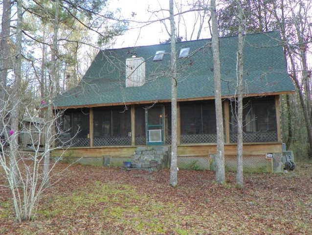
Timberland Cabin style home on 32.75 acres in Worth County. Private setting in woods with beautiful lake and abundant turkey, deer & other wildlife. Hardwood floors, tongue and grove walls, vaulted ceiling w/heavy exposed beams. Open design with kitchen overlooking great room w/fireplace, island in kitchen with double sink, seats 4 at bar plus dining area, large walk-in pantry, dbl. ovens, dishwasher, & disposal, spacious master suite w/french doors opening to screened porch, spiral staircase leads to upstairs w/2 add'l bedrooms with vaulted ceilings, loft area w/closet fits twin bed. Dbl.french doors in great room open to screened porch with fabulous view of 2 acre lake with bass, bream and catfish. Large screened porch overlooks lake. 24 x 75 detached carport. HVAC systems and roof less than 2 years old. A unique opportunity to enjoy your own private retreat nestled in the woods.
Last Agent to Sell the Property
Re/Max Of Albany Brokerage Phone: 2294341600 License #127976 Listed on: 02/23/2017
Last Buyer's Agent
Non-Member Agent
Non Member Office
| Date | Buyer | Sale Price | Title Company |
|---|---|---|---|
| Downs Ronald | $29,000 | -- | |
| Downs Ronald | $235,000 | -- | |
| Mccomas John E | $220,000 | -- |
| Date | Status | Borrower | Loan Amount |
|---|---|---|---|
| Previous Owner | Downs Ronald | $220,000 | |
| Previous Owner | Downs Ronald | $229,761 |
| Date | Event | Price | List to Sale | Price per Sq Ft |
|---|---|---|---|---|
| 05/15/2017 05/15/17 | Sold | $235,000 | -- | $107 / Sq Ft |
| 02/23/2017 02/23/17 | Pending | -- | -- | -- |
| Year | Tax Paid | Tax Assessment Tax Assessment Total Assessment is a certain percentage of the fair market value that is determined by local assessors to be the total taxable value of land and additions on the property. | Land | Improvement |
|---|---|---|---|---|
| 2024 | $2,073 | $80,636 | $28,594 | $52,042 |
| 2023 | $2,073 | $81,236 | $28,594 | $52,642 |
| 2022 | $2,108 | $81,236 | $28,594 | $52,642 |
| 2021 | $2,079 | $81,236 | $28,594 | $52,642 |
| 2020 | $2,076 | $81,236 | $28,594 | $52,642 |
| 2019 | $2,046 | $81,236 | $28,594 | $52,642 |
| 2018 | $2,327 | $81,236 | $28,594 | $52,642 |
| 2017 | $2,327 | $81,236 | $28,594 | $52,642 |
| 2016 | $1,789 | $81,236 | $28,594 | $52,642 |
| 2015 | $1,786 | $80,548 | $27,906 | $52,642 |
| 2014 | $1,623 | $79,428 | $27,650 | $51,778 |
| 2013 | -- | $81,816 | $30,038 | $51,778 |
| 2012 | -- | $82,705 | $30,928 | $51,777 |
Seller's Agent in 2017
Debbie Fulford
Re/Max Of Albany
156 Total Sales
N
Buyer's Agent in 2017
Non-Member Agent
Non Member Office
Source: Albany Board of REALTORS®
MLS Number: 137832
APN: 00460-020-00B