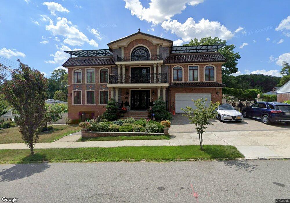
6466 211th St Bayside, NY 11364
Oakland Gardens NeighborhoodEstimated Value: $1,200,000 - $2,515,000
3
Beds
3
Baths
10,000
Sq Ft
$186/Sq Ft
Est. Value
About This Home
This home is located at 6466 211th St, Bayside, NY 11364 and is currently estimated at $1,856,996, approximately $185 per square foot. 6466 211th St is a home located in Queens County with nearby schools including P.S. 46 - Alley Pond, Nathaniel Hawthorne Middle School 74, and Benjamin N Cardozo High School.
Ownership History
Date
Name
Owned For
Owner Type
Purchase Details
Closed on
Apr 22, 2014
Sold by
Lee I-Hao and Lee I-Lung
Bought by
Ho Guo Hung
Current Estimated Value
Purchase Details
Closed on
Feb 28, 1995
Sold by
Lung Lee I Hao and Lung Lee I
Bought by
Lung Lee I Hao and Lung Lee I
Create a Home Valuation Report for This Property
The Home Valuation Report is an in-depth analysis detailing your home's value as well as a comparison with similar homes in the area
Home Values in the Area
Average Home Value in this Area
Purchase History
| Date | Buyer | Sale Price | Title Company |
|---|---|---|---|
| Ho Guo Hung | $900,000 | -- | |
| Ho Guo Hung | $900,000 | -- | |
| Lung Lee I Hao | -- | First American Title Ins Co | |
| Lung Lee I | -- | First American Title Ins Co |
Source: Public Records
Tax History Compared to Growth
Tax History
| Year | Tax Paid | Tax Assessment Tax Assessment Total Assessment is a certain percentage of the fair market value that is determined by local assessors to be the total taxable value of land and additions on the property. | Land | Improvement |
|---|---|---|---|---|
| 2025 | $31,121 | $159,244 | $29,576 | $129,668 |
| 2024 | $31,121 | $154,946 | $27,035 | $127,911 |
| 2023 | $31,102 | $154,854 | $27,413 | $127,441 |
| 2022 | $29,164 | $166,260 | $30,600 | $135,660 |
| 2021 | $29,004 | $137,820 | $30,600 | $107,220 |
| 2020 | $28,089 | $145,020 | $30,600 | $114,420 |
| 2019 | $27,011 | $159,720 | $30,600 | $129,120 |
| 2018 | $26,322 | $129,122 | $23,187 | $105,935 |
| 2017 | $25,330 | $124,260 | $30,600 | $93,660 |
| 2016 | $24,841 | $124,260 | $30,600 | $93,660 |
| 2015 | $6,744 | $52,750 | $28,681 | $24,069 |
| 2014 | $6,744 | $49,766 | $27,058 | $22,708 |
Source: Public Records
Map
Nearby Homes
- 67-29 211th St
- 64-16 211th St
- 67-52 212th St
- 210-12 69th Ave Unit Lower
- 64-07 213th St
- 211-8 69th Ave Unit 1A
- 69-27 210th St Unit 2
- 64-58 215th St
- 69-29 210th St Unit A
- 211-11 73rd Ave Unit B
- 64-47 215 St
- 211-19A 73rd Ave Unit Lower
- 67-10 Bell Blvd
- 61-20 214th St
- 64-64 Bell Blvd
- 212-12 73rd Ave Unit 5C
- 213-15 73rd Ave
- 213-15 73rd Ave Unit LOWER
- 67-01 Bell Blvd Unit DUPLE
- 213-25 73rd Ave Unit B