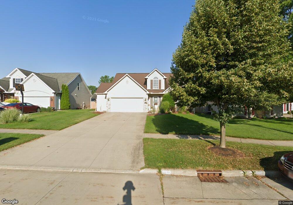
6474 Scott Dr Brookpark, OH 44142
Estimated Value: $316,000 - $374,734
3
Beds
4
Baths
2,004
Sq Ft
$175/Sq Ft
Est. Value
About This Home
This home is located at 6474 Scott Dr, Brookpark, OH 44142 and is currently estimated at $351,684, approximately $175 per square foot. 6474 Scott Dr is a home located in Cuyahoga County with nearby schools including Berea-Midpark Middle School, Berea-Midpark High School, and The Academy of St. Bartholomew.
Ownership History
Date
Name
Owned For
Owner Type
Purchase Details
Closed on
May 15, 2023
Sold by
Duplaga Brenda Mae
Bought by
Brenda Mae Duplaga Revocable Living Trust
Current Estimated Value
Purchase Details
Closed on
Feb 2, 2005
Sold by
Fireside Builders Llc
Bought by
Duplaga Ralph and Duplaga Brenda M
Home Financials for this Owner
Home Financials are based on the most recent Mortgage that was taken out on this home.
Original Mortgage
$208,000
Interest Rate
3.25%
Mortgage Type
Purchase Money Mortgage
Create a Home Valuation Report for This Property
The Home Valuation Report is an in-depth analysis detailing your home's value as well as a comparison with similar homes in the area
Home Values in the Area
Average Home Value in this Area
Purchase History
| Date | Buyer | Sale Price | Title Company |
|---|---|---|---|
| Brenda Mae Duplaga Revocable Living Trust | -- | None Listed On Document | |
| Duplaga Ralph | $261,426 | Guardian Title & Guaranty |
Source: Public Records
Mortgage History
| Date | Status | Borrower | Loan Amount |
|---|---|---|---|
| Previous Owner | Duplaga Ralph | $208,000 | |
| Closed | Duplaga Ralph | $26,000 |
Source: Public Records
Tax History
| Year | Tax Paid | Tax Assessment Tax Assessment Total Assessment is a certain percentage of the fair market value that is determined by local assessors to be the total taxable value of land and additions on the property. | Land | Improvement |
|---|---|---|---|---|
| 2025 | $6,248 | $124,635 | $23,870 | $100,765 |
| 2024 | $6,286 | $124,635 | $23,870 | $100,765 |
| 2023 | $5,405 | $88,730 | $20,090 | $68,640 |
| 2022 | $5,367 | $88,730 | $20,090 | $68,640 |
| 2021 | $5,335 | $88,730 | $20,090 | $68,640 |
| 2020 | $5,462 | $79,940 | $18,100 | $61,850 |
| 2019 | $5,298 | $228,400 | $51,700 | $176,700 |
| 2018 | $4,953 | $79,940 | $18,100 | $61,850 |
| 2017 | $5,015 | $70,180 | $16,280 | $53,900 |
| 2016 | $4,973 | $70,180 | $16,280 | $53,900 |
| 2015 | $4,914 | $70,180 | $16,280 | $53,900 |
| 2014 | $4,914 | $73,890 | $17,120 | $56,770 |
Source: Public Records
Map
Nearby Homes
- 6490 Grosse Dr
- 6577 Liberty Bell Dr Unit C20
- 6755 Benedict Dr
- 6728 Benedict Dr
- 6748 Benedict Dr
- 6752 Benedict Dr
- 6744 Benedict Dr
- 6720 Benedict Dr
- 6724 Benedict Dr
- 6016 Gilmere Dr
- 6448 Delores Blvd
- 6188 Barbara Ln
- 6689 Fry Rd
- 6330 Ledgebrook Dr
- 6377 Ledgebrook Dr
- 16460 Heather Ln
- 6386 Sandfield Dr
- 6707 Woodruff Ct
- 6330 Sandfield Dr
- 16495 Heather Ln Unit F103
Your Personal Tour Guide
Ask me questions while you tour the home.