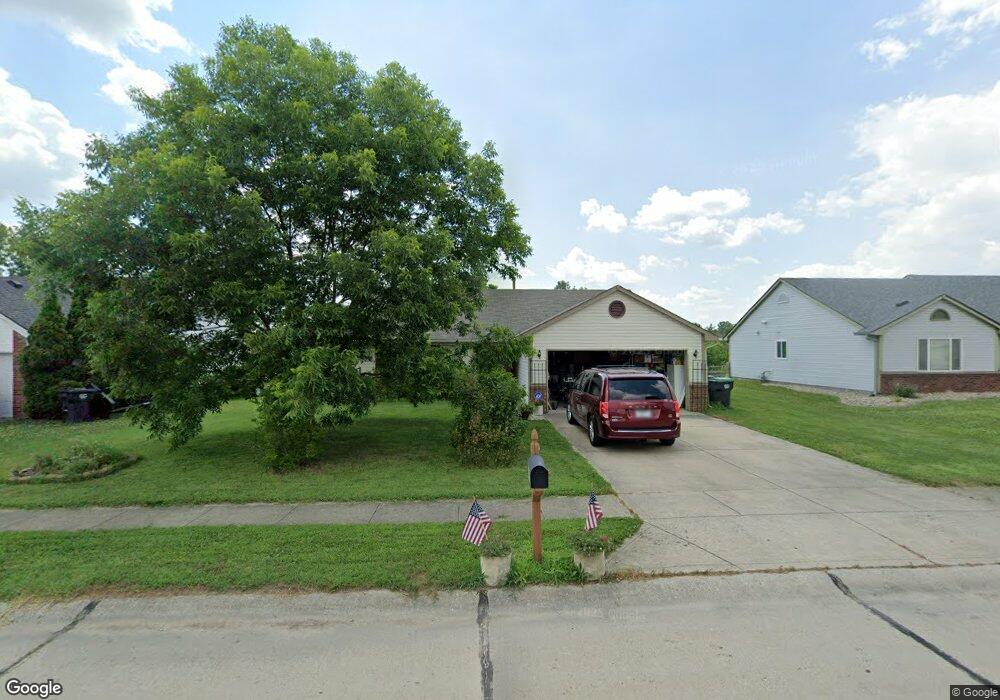
648 Saraina Ln Whiteland, IN 46184
Estimated Value: $242,000 - $271,363
3
Beds
2
Baths
1,200
Sq Ft
$211/Sq Ft
Est. Value
About This Home
This home is located at 648 Saraina Ln, Whiteland, IN 46184 and is currently estimated at $253,091, approximately $210 per square foot. 648 Saraina Ln is a home located in Johnson County with nearby schools including Break-O-Day Elementary School, Clark-Pleasant Middle School, and Whiteland Community High School.
Ownership History
Date
Name
Owned For
Owner Type
Purchase Details
Closed on
Aug 5, 2011
Sold by
Jordan Monte R and Jordan Verna J
Bought by
Frymire Thomas W and Frymire Gloria D
Current Estimated Value
Home Financials for this Owner
Home Financials are based on the most recent Mortgage that was taken out on this home.
Original Mortgage
$75,000
Outstanding Balance
$52,098
Interest Rate
4.64%
Mortgage Type
New Conventional
Estimated Equity
$200,993
Purchase Details
Closed on
Sep 8, 2006
Sold by
Garmon Gerald W and Garmon Lisa K
Bought by
Jordan Monte R and Jordan Verna J
Home Financials for this Owner
Home Financials are based on the most recent Mortgage that was taken out on this home.
Original Mortgage
$90,400
Interest Rate
7%
Mortgage Type
Adjustable Rate Mortgage/ARM
Create a Home Valuation Report for This Property
The Home Valuation Report is an in-depth analysis detailing your home's value as well as a comparison with similar homes in the area
Home Values in the Area
Average Home Value in this Area
Purchase History
| Date | Buyer | Sale Price | Title Company |
|---|---|---|---|
| Frymire Thomas W | -- | Investors Titlecorp | |
| Jordan Monte R | -- | Stewart Title |
Source: Public Records
Mortgage History
| Date | Status | Borrower | Loan Amount |
|---|---|---|---|
| Open | Frymire Thomas W | $75,000 | |
| Previous Owner | Jordan Monte R | $90,400 |
Source: Public Records
Tax History Compared to Growth
Tax History
| Year | Tax Paid | Tax Assessment Tax Assessment Total Assessment is a certain percentage of the fair market value that is determined by local assessors to be the total taxable value of land and additions on the property. | Land | Improvement |
|---|---|---|---|---|
| 2025 | $1,998 | $219,300 | $51,000 | $168,300 |
| 2024 | $1,998 | $197,900 | $51,000 | $146,900 |
| 2023 | $1,997 | $191,700 | $51,000 | $140,700 |
| 2022 | $1,757 | $170,100 | $32,000 | $138,100 |
| 2021 | $1,403 | $136,000 | $32,000 | $104,000 |
| 2020 | $1,283 | $124,000 | $26,400 | $97,600 |
| 2019 | $1,249 | $120,800 | $26,400 | $94,400 |
| 2018 | $1,241 | $127,200 | $33,600 | $93,600 |
| 2017 | $1,160 | $114,100 | $33,600 | $80,500 |
| 2016 | $1,151 | $114,100 | $33,600 | $80,500 |
| 2014 | $977 | $99,000 | $33,600 | $65,400 |
| 2013 | $977 | $116,100 | $33,600 | $82,500 |
Source: Public Records
Map
Nearby Homes
- 647 Bluestem Cir
- 76 Fernleaf Dr
- 12 Rypma Row
- Liberty Plan at Crossroads at Southport
- 7331 Deerberg Dr
- Jefferson Plan at Crossroads at Southport
- 7338 Deerberg Dr
- Rushmore Plan at Crossroads at Southport
- Lincoln Plan at Crossroads at Southport
- Washington Plan at Crossroads at Southport
- 346 Switchgrass Ln
- 731 W 600 N
- 821 Princeton Dr
- 143 Tracy Ridge Blvd
- 230 Parkview Dr
- 239 Shelton Place
- 106 Tracy Ridge Blvd
- 250 Southlane Dr
- 135 Bradford Place
- 0 E 700 N Unit MBR22036500