Estimated Value: $333,000 - $399,000
4
Beds
2
Baths
2,264
Sq Ft
$161/Sq Ft
Est. Value
About This Home
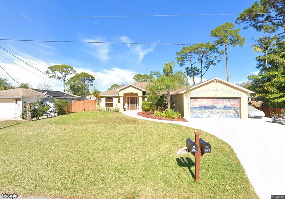
This home is located at 6481 Hunt Rd, Cocoa, FL 32927 and is currently estimated at $365,073, approximately $161 per square foot. 6481 Hunt Rd is a home located in Brevard County with nearby schools including Challenger 7 Elementary School, Space Coast Junior/Senior High School, and Sculptor Charter School.
Ownership History
Date
Name
Owned For
Owner Type
Purchase Details
Closed on
Jun 29, 2001
Sold by
Holiday Bldr Inc
Bought by
Orend Joseph S and Orend Trisha L
Current Estimated Value
Home Financials for this Owner
Home Financials are based on the most recent Mortgage that was taken out on this home.
Original Mortgage
$89,150
Interest Rate
7.17%
Purchase Details
Closed on
Feb 2, 2001
Sold by
Cinquemani Charles
Bought by
Holiday Bldr Inc
Create a Home Valuation Report for This Property
The Home Valuation Report is an in-depth analysis detailing your home's value as well as a comparison with similar homes in the area
Home Values in the Area
Average Home Value in this Area
Purchase History
| Date | Buyer | Sale Price | Title Company |
|---|---|---|---|
| Orend Joseph S | $101,200 | -- | |
| Holiday Bldr Inc | $10,000 | -- |
Source: Public Records
Mortgage History
| Date | Status | Borrower | Loan Amount |
|---|---|---|---|
| Open | Holiday Bldr Inc | $89,150 | |
| Closed | Orend Joseph S | $89,150 |
Source: Public Records
Tax History
| Year | Tax Paid | Tax Assessment Tax Assessment Total Assessment is a certain percentage of the fair market value that is determined by local assessors to be the total taxable value of land and additions on the property. | Land | Improvement |
|---|---|---|---|---|
| 2025 | $1,940 | $139,960 | -- | -- |
| 2024 | $1,896 | $136,020 | -- | -- |
| 2023 | $1,896 | $132,060 | -- | -- |
| 2022 | $1,591 | $113,570 | $0 | $0 |
| 2021 | $1,589 | $110,270 | $0 | $0 |
| 2020 | $1,499 | $108,750 | $0 | $0 |
| 2019 | $1,432 | $106,310 | $0 | $0 |
| 2018 | $1,423 | $104,330 | $0 | $0 |
| 2017 | $1,412 | $102,190 | $0 | $0 |
| 2016 | $1,414 | $100,090 | $18,000 | $82,090 |
| 2015 | $1,431 | $99,400 | $15,000 | $84,400 |
| 2014 | $1,433 | $98,620 | $11,000 | $87,620 |
Source: Public Records
Map
Nearby Homes
- 4721 Fairsun St
- 6310 Depot Ave
- 4590 Ponds Dr
- 0000 Unknown St
- 4715 Greenhill St
- 4790 Greenhill St
- 4470 Ponds Dr
- 0000 Grissom Pkwy
- 4975 Fay Blvd
- 6162 Rena Ave
- 6375 Cable Ave
- 4390 Ponds Dr
- 4485 Fay Blvd
- 4440 Fay Blvd
- 6398 Cable Ave
- 6240 Grissom Pkwy
- 6620 Grissom Pkwy
- 4240 Ponds Dr
- 4300 Fay Blvd
- 4760 Ivan St
Your Personal Tour Guide
Ask me questions while you tour the home.