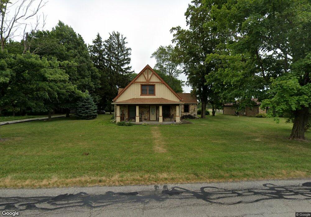
649 N County Road 200 E Danville, IN 46122
Estimated Value: $245,000 - $303,000
2
Beds
1
Bath
1,296
Sq Ft
$204/Sq Ft
Est. Value
About This Home
This home is located at 649 N County Road 200 E, Danville, IN 46122 and is currently estimated at $263,765, approximately $203 per square foot. 649 N County Road 200 E is a home located in Hendricks County with nearby schools including North Elementary School, South Elementary School, and Danville Middle School.
Ownership History
Date
Name
Owned For
Owner Type
Purchase Details
Closed on
Jul 20, 2021
Sold by
Unison Group Llc
Bought by
Carter David Albert
Current Estimated Value
Home Financials for this Owner
Home Financials are based on the most recent Mortgage that was taken out on this home.
Original Mortgage
$169,696
Outstanding Balance
$154,114
Interest Rate
2.96%
Mortgage Type
New Conventional
Estimated Equity
$109,651
Purchase Details
Closed on
Sep 14, 2009
Sold by
Konechnik Anthony J and Konechnik Joanna M
Bought by
Konechnik Anthony J and Konechnik Thomas J
Create a Home Valuation Report for This Property
The Home Valuation Report is an in-depth analysis detailing your home's value as well as a comparison with similar homes in the area
Home Values in the Area
Average Home Value in this Area
Purchase History
| Date | Buyer | Sale Price | Title Company |
|---|---|---|---|
| Carter David Albert | $168,000 | None Available | |
| Konechnik Anthony J | -- | None Available |
Source: Public Records
Mortgage History
| Date | Status | Borrower | Loan Amount |
|---|---|---|---|
| Open | Carter David Albert | $169,696 |
Source: Public Records
Tax History Compared to Growth
Tax History
| Year | Tax Paid | Tax Assessment Tax Assessment Total Assessment is a certain percentage of the fair market value that is determined by local assessors to be the total taxable value of land and additions on the property. | Land | Improvement |
|---|---|---|---|---|
| 2024 | $1,901 | $211,100 | $43,800 | $167,300 |
| 2023 | $1,706 | $192,900 | $39,800 | $153,100 |
| 2022 | $1,784 | $183,700 | $37,900 | $145,800 |
| 2021 | $1,648 | $83,300 | $19,000 | $64,300 |
| 2020 | $1,666 | $83,300 | $19,700 | $63,600 |
| 2019 | $1,666 | $83,300 | $17,200 | $66,100 |
| 2018 | $1,592 | $79,600 | $17,000 | $62,600 |
| 2017 | $1,592 | $79,600 | $17,200 | $62,400 |
| 2016 | $219 | $79,600 | $17,500 | $62,100 |
| 2014 | $690 | $120,500 | $28,000 | $92,500 |
Source: Public Records
Map
Nearby Homes
- Courtyard 1752 Plan at Quail West
- Courtyard 1586 Plan at Quail West
- Courtyard 2056 Plan at Quail West
- Courtyard 1934 Plan at Quail West
- Courtyard 1601 Plan at Quail West
- 2169 Aviary Ln
- 2201 Aviary Ln
- 1015 Bevy Blvd
- 2249 Aviary Ln
- 2257 Aviary Ln
- 1045 Bevy Blvd
- 396 Tradition Ln
- 2068 Quail Dr W
- Henley Plan at Quail West
- Chatham Plan at Quail West
- 335 Concord Dr E
- 1085 Bevy Blvd
- 1780 10th St
- Legacy 2634 Plan at The Bevy
- Legacy 2307 Plan at The Bevy
- 687 N County Road 200 E
- 645 N County Road 200 E
- 745 N County Road 200 E
- 641 N County Road 200 E
- 783 N County Road 200 E
- 808 N County Road 200 E
- 407 N County Road 200 E
- 833 N County Road 200 E
- 1990 Whisperwood Trail
- 1980 Whisperwood Trail
- 837 Tyne Cir
- 1971 Whisperwood Trail
- 857 Tyne Cir
- 1955 Abbey Ln
- 1953 Abbey Ln
- 1951 Abbey Ln
- 1961 Whisperwood Trail
- 818 Tyne Cir
- 1949 Abbey Ln
- 869 Tyne Cir