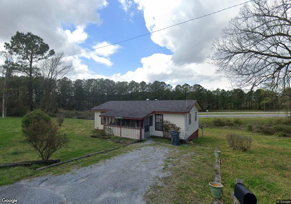
649 Tallapoosa St W Bremen, GA 30110
Estimated Value: $132,000 - $221,000
2
Beds
1
Bath
880
Sq Ft
$183/Sq Ft
Est. Value
About This Home
This home is located at 649 Tallapoosa St W, Bremen, GA 30110 and is currently estimated at $160,667, approximately $182 per square foot. 649 Tallapoosa St W is a home located in Haralson County with nearby schools including Jones Elementary School, Bremen 4th & 5th Grade Academy, and Bremen Middle School.
Ownership History
Date
Name
Owned For
Owner Type
Purchase Details
Closed on
Nov 4, 2022
Sold by
Thomas Rebecca E
Bought by
Thomas Andre L
Current Estimated Value
Home Financials for this Owner
Home Financials are based on the most recent Mortgage that was taken out on this home.
Original Mortgage
$96,662
Outstanding Balance
$92,690
Interest Rate
5.37%
Mortgage Type
FHA
Estimated Equity
$67,977
Purchase Details
Closed on
Jun 2, 1990
Bought by
Thomas Rebecca Edmonson
Create a Home Valuation Report for This Property
The Home Valuation Report is an in-depth analysis detailing your home's value as well as a comparison with similar homes in the area
Home Values in the Area
Average Home Value in this Area
Purchase History
| Date | Buyer | Sale Price | Title Company |
|---|---|---|---|
| Thomas Andre L | $100,000 | -- | |
| Thomas Rebecca Edmonson | -- | -- |
Source: Public Records
Mortgage History
| Date | Status | Borrower | Loan Amount |
|---|---|---|---|
| Open | Thomas Andre L | $96,662 |
Source: Public Records
Tax History Compared to Growth
Tax History
| Year | Tax Paid | Tax Assessment Tax Assessment Total Assessment is a certain percentage of the fair market value that is determined by local assessors to be the total taxable value of land and additions on the property. | Land | Improvement |
|---|---|---|---|---|
| 2024 | $552 | $19,667 | $6,420 | $13,247 |
| 2023 | $631 | $21,006 | $5,400 | $15,606 |
| 2022 | $171 | $17,747 | $5,400 | $12,347 |
| 2021 | $133 | $17,150 | $5,400 | $11,750 |
| 2020 | $139 | $17,673 | $5,400 | $12,273 |
| 2019 | $124 | $15,795 | $5,400 | $10,395 |
| 2018 | $126 | $15,795 | $5,400 | $10,395 |
| 2017 | $129 | $14,856 | $5,400 | $9,456 |
| 2016 | $155 | $16,477 | $5,400 | $11,077 |
| 2015 | $153 | $16,350 | $5,400 | $10,951 |
| 2014 | $198 | $18,951 | $8,000 | $10,951 |
Source: Public Records
Map
Nearby Homes
- 735 Tallapoosa St W
- 6315 Highway 78
- 522 Atlantic Ave
- 0 Sewell Rd Unit 10624236
- 0 Sewell Rd Unit 7665305
- 0 Mt Zion St Unit 7399245
- 273 Sewell Rd
- 225 Edwards St
- 319 Stonebridge Blvd
- 330 Kensington Cir
- 321 Stonebridge Blvd
- 707 Mill Stone Way
- 0 Stonebridge Blvd Unit 143588
- 201 Stonebridge Blvd
- 311 Kensington Cir
- 153 Crest Pointe
- 327 Crest Pointe S
- 138 Crest Pointe
- 0 Tallapoosa St Unit 7186909
- 0 Tallapoosa St Unit 7034784
- 0 Tallapoosa St
- W Tallapoosa St
- 641 Tallapoosa St W
- 769 Atlantic Ave
- 106 Hayes Glass Dr
- 718 Atlanta St
- 627 Tallapoosa St W
- 704 Atlantic Ave
- 704 Atlantic Ave
- 700 Atlantic Ave
- 706 Atlanta St
- 634 Atlantic Ave
- 217 Parham St
- 152 Robinson St
- 150 Robinson St
- 630 Atlantic Ave
- 226 Parham St
- 148 Robinson St