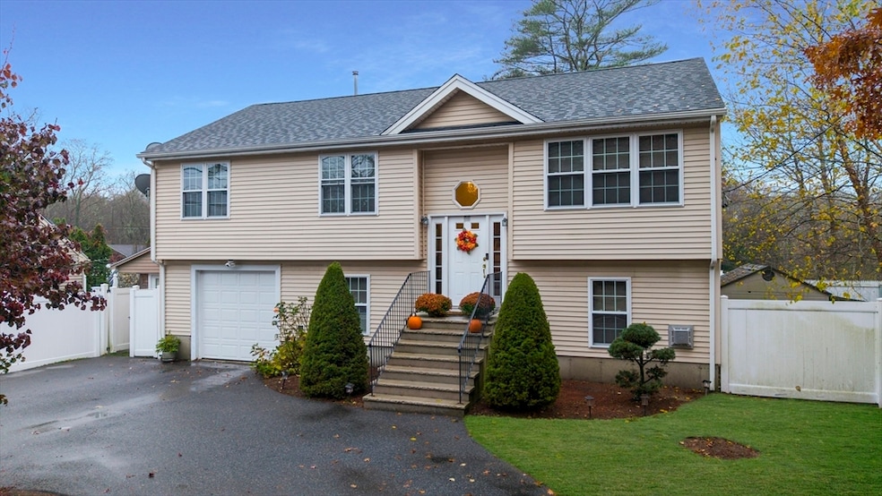
65 Cross Rd Dartmouth, MA 02747
Smith Mills NeighborhoodEstimated payment $3,351/month
Highlights
- Golf Course Community
- Deck
- Raised Ranch Architecture
- Medical Services
- Property is near public transit
- Wood Flooring
About This Home
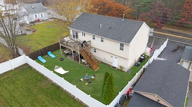
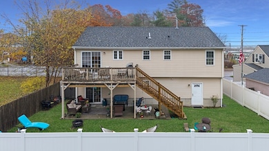
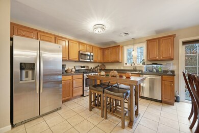
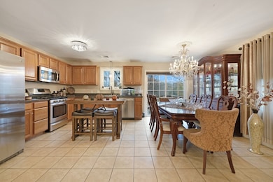
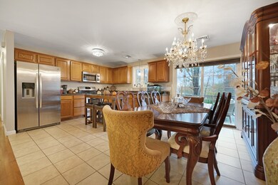
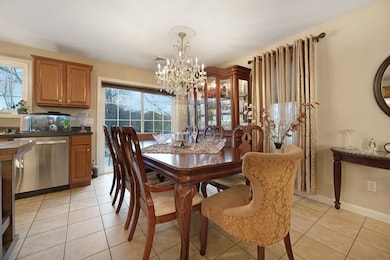
Welcome to 65 Cross Road in Dartmouth - a spacious raised ranch offering over 2,000 square feet of comfortable living space in a convenient location. The main level features an open layout with hardwood flooring throughout, three bedrooms, and two full baths. The home is equipped with forced hot air heating and central air, ensuring year-round comfort.The lower level provides a versatile bonus room, a third full bath, and direct walkout access to a newly added patio beneath the deck - perfect for relaxing or entertaining. Outside, you’ll find a fully fenced-in yard and low-maintenance vinyl siding, offering both privacy and easy upkeep.A great opportunity to own a well-maintained home that combines space, functionality, and value in one of Dartmouth’s most desirable areas. Open house Saturday and Sunday, November 22nd & 23rd from 11:00am-1:00pm.

Open House Schedule
-
Saturday, November 22, 202511:00 am to 1:00 pm11/22/2025 11:00:00 AM +00:0011/22/2025 1:00:00 PM +00:00Add to Calendar
-
Sunday, November 23, 202511:00 am to 1:00 pm11/23/2025 11:00:00 AM +00:0011/23/2025 1:00:00 PM +00:00Add to Calendar
Home Details
Home Type
- Single Family
Est. Annual Taxes
- $3,543
Year Built
- Built in 2010
Lot Details
- 5,663 Sq Ft Lot
- Fenced Yard
- Level Lot
Parking
- 1 Car Attached Garage
- Garage Door Opener
- Driveway
- Open Parking
- Off-Street Parking
Home Design
- Raised Ranch Architecture
- Concrete Perimeter Foundation
Interior Spaces
- 1 Fireplace
Kitchen
- Range
- Dishwasher
Flooring
- Wood
- Carpet
Bedrooms and Bathrooms
- 3 Bedrooms
- 3 Full Bathrooms
Finished Basement
- Walk-Out Basement
- Basement Fills Entire Space Under The House
- Interior Basement Entry
- Garage Access
Outdoor Features
- Deck
Location
- Property is near public transit
- Property is near schools
Schools
- Potter Elementary School
- Dartmouth Middle School
- Dartmouth High School
Utilities
- Forced Air Heating and Cooling System
- Heating System Uses Natural Gas
- 200+ Amp Service
- Gas Water Heater
Listing and Financial Details
- Assessor Parcel Number 2789104
Community Details
Overview
- No Home Owners Association
- Near Conservation Area
Amenities
- Medical Services
- Shops
Recreation
- Golf Course Community
- Park
Map
Home Values in the Area
Average Home Value in this Area
Tax History
| Year | Tax Paid | Tax Assessment Tax Assessment Total Assessment is a certain percentage of the fair market value that is determined by local assessors to be the total taxable value of land and additions on the property. | Land | Improvement |
|---|---|---|---|---|
| 2025 | $3,543 | $391,500 | $118,400 | $273,100 |
| 2024 | $3,393 | $371,200 | $118,400 | $252,800 |
| 2023 | $3,289 | $339,400 | $118,400 | $221,000 |
| 2022 | $3,269 | $315,500 | $118,400 | $197,100 |
| 2021 | $3,332 | $307,700 | $114,900 | $192,800 |
| 2020 | $3,235 | $297,300 | $113,700 | $183,600 |
| 2019 | $3,054 | $281,500 | $109,100 | $172,400 |
| 2018 | $3,207 | $265,700 | $111,400 | $154,300 |
| 2017 | $2,756 | $259,000 | $103,000 | $156,000 |
| 2016 | $2,505 | $236,800 | $91,100 | $145,700 |
| 2015 | $2,441 | $232,300 | $85,100 | $147,200 |
| 2014 | $2,362 | $226,200 | $82,700 | $143,500 |
Property History
| Date | Event | Price | List to Sale | Price per Sq Ft |
|---|---|---|---|---|
| 11/17/2025 11/17/25 | For Sale | $579,900 | -- | $281 / Sq Ft |
Purchase History
| Date | Type | Sale Price | Title Company |
|---|---|---|---|
| Deed | $220,000 | -- | |
| Deed | $65,000 | -- |
Mortgage History
| Date | Status | Loan Amount | Loan Type |
|---|---|---|---|
| Closed | $220,000 | Purchase Money Mortgage |
Source: MLS Property Information Network (MLS PIN)
MLS Number: 73455641
APN: DART-000165-000070
Disclaimer: Certain information contained herein is derived from information provided by parties other than Homes.com. All information provided is deemed reliable, but is not guaranteed to be accurate and should be independently verified.
![]() The property listing data and information, or the Images, set forth herein were provided to MLS Property Information Network, Inc. from third party sources, including sellers, lessors and public records, and were compiled by MLS Property Information Network, Inc. The property listing data and information, and the Images, are for the personal, non-commercial use of consumers having a good faith interest in purchasing or leasing listed properties of the type displayed to them and may not be used for any purpose other than to identify prospective properties which such consumers may have a good faith interest in purchasing or leasing. MLS Property Information Network, Inc. and its subscribers disclaim any and all representations and warranties as to the accuracy of the property listing data and information, or as to the accuracy of any of the Images, set forth herein.
The property listing data and information, or the Images, set forth herein were provided to MLS Property Information Network, Inc. from third party sources, including sellers, lessors and public records, and were compiled by MLS Property Information Network, Inc. The property listing data and information, and the Images, are for the personal, non-commercial use of consumers having a good faith interest in purchasing or leasing listed properties of the type displayed to them and may not be used for any purpose other than to identify prospective properties which such consumers may have a good faith interest in purchasing or leasing. MLS Property Information Network, Inc. and its subscribers disclaim any and all representations and warranties as to the accuracy of the property listing data and information, or as to the accuracy of any of the Images, set forth herein.
- 63 Brandt Ave
- 53 Morton Ave
- 310 Old Westport Rd
- 312 Old Westport Rd
- 28 Greystone Ave
- 320 Old Westport Rd
- 73 Juliette St
- 135 Old Westport Rd
- Lot 6 Rafael Rd
- 117 Old Westport Rd
- 4 Sabrina Way Unit A
- 4 Sabrina Way Unit C
- 4 Sabrina Way Unit B
- 4 Sabrina Way Unit D
- 0 Undisclosed Unit 73376281
- 46 Old Westport Rd
- 0 Mosher Ln Unit 73370974
- 368 Cross Rd
- 1406 Tucker Rd
- 50 Lyng St
- 629 State Rd
- 42 W Hill Rd
- 871 Allen St
- 50 Oesting St
- 42 Fairmount St
- 896 Rockdale Ave Unit 1
- 710 Elm St
- 58 Shawmut Ave Unit 3
- 447 Ash St Unit 3
- 685 Cottage St
- 685 Cottage St Unit 1
- 231 Allen St Unit 1
- 97 Hazard St Unit 3
- 110 Reynolds St Unit 1W
- 314 Dartmouth St Unit 2
- 278 Dartmouth St Unit 1
- 28 Borden St Unit 1
- 62 Thomas St Unit 2
- 148 Maxfield St Unit 1W
- 148 Maxfield St Unit 3