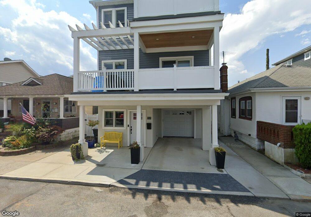
65 Delaware Ave Long Beach, NY 11561
Estimated Value: $1,201,287 - $1,359,000
Studio
2
Baths
2,024
Sq Ft
$632/Sq Ft
Est. Value
About This Home
This home is located at 65 Delaware Ave, Long Beach, NY 11561 and is currently estimated at $1,280,144, approximately $632 per square foot. 65 Delaware Ave is a home located in Nassau County with nearby schools including Lido Elementary School, West Elementary School, and Lindell Elementary School.
Ownership History
Date
Name
Owned For
Owner Type
Purchase Details
Closed on
Dec 27, 2017
Sold by
Salter Timothy W
Bought by
Salter Timothy W and Leung Amy
Current Estimated Value
Purchase Details
Closed on
Mar 27, 2015
Sold by
Salter Judy Ann and Salter Timothy W
Bought by
Salter Timothy W
Home Financials for this Owner
Home Financials are based on the most recent Mortgage that was taken out on this home.
Original Mortgage
$225,000
Outstanding Balance
$173,398
Interest Rate
3.77%
Mortgage Type
New Conventional
Estimated Equity
$1,106,746
Create a Home Valuation Report for This Property
The Home Valuation Report is an in-depth analysis detailing your home's value as well as a comparison with similar homes in the area
Home Values in the Area
Average Home Value in this Area
Purchase History
| Date | Buyer | Sale Price | Title Company |
|---|---|---|---|
| Salter Timothy W | -- | -- | |
| Salter Timothy W | -- | None Available |
Source: Public Records
Mortgage History
| Date | Status | Borrower | Loan Amount |
|---|---|---|---|
| Open | Salter Timothy W | $225,000 |
Source: Public Records
Tax History
| Year | Tax Paid | Tax Assessment Tax Assessment Total Assessment is a certain percentage of the fair market value that is determined by local assessors to be the total taxable value of land and additions on the property. | Land | Improvement |
|---|---|---|---|---|
| 2025 | $6,408 | $778 | $245 | $533 |
| 2024 | $745 | $778 | $245 | $533 |
Source: Public Records
Map
Nearby Homes
- 59 Delaware Ave
- 56 Oregon St
- 90 Oregon St
- 77 Nebraska St
- 84 Nebraska St
- 74 Wisconsin St
- 92 Nebraska St
- 853 W Park Ave
- 97 Wisconsin St
- 101 California St
- 91 Virginia Ave
- 99 Virginia Ave
- 821 W Park Ave
- 925 W Park Ave
- 23 Virginia Ave
- 105 Vermont St
- 923 Oceanfront St
- 931 Oceanfront St
- 27 June Walk
- 781 W Park Ave
- 63 Delaware Ave
- 67 Delaware Ave
- 61 Delaware Ave
- 66 Alabama St
- 69 Delaware Ave
- 64 Alabama St
- 64 Alabama St Unit House
- 68 Alabama St
- 62 Alabama St
- 70 Alabama St
- 71 Delaware Ave
- 71 Delaware Ave Unit House
- 66 Delaware Ave
- 72 Alabama St
- 68 Delaware Ave
- 64 Delaware Ave
- 70 Delaware Ave
- 70 Delaware Ave Unit Lower
- 73 Delaware Ave
- 73 Delaware Ave Unit House
Your Personal Tour Guide
Ask me questions while you tour the home.