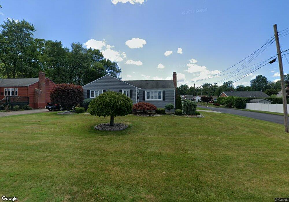
65 Edward St Wethersfield, CT 06109
Estimated Value: $371,000 - $392,083
3
Beds
2
Baths
1,225
Sq Ft
$308/Sq Ft
Est. Value
About This Home
This home is located at 65 Edward St, Wethersfield, CT 06109 and is currently estimated at $377,271, approximately $307 per square foot. 65 Edward St is a home located in Hartford County with nearby schools including Emerson-Williams School, Silas Deane Middle School, and Wethersfield High School.
Ownership History
Date
Name
Owned For
Owner Type
Purchase Details
Closed on
Apr 27, 1987
Sold by
Tonucci Romolo
Bought by
Capasso Mario
Current Estimated Value
Create a Home Valuation Report for This Property
The Home Valuation Report is an in-depth analysis detailing your home's value as well as a comparison with similar homes in the area
Home Values in the Area
Average Home Value in this Area
Purchase History
| Date | Buyer | Sale Price | Title Company |
|---|---|---|---|
| Capasso Mario | $125,000 | -- |
Source: Public Records
Mortgage History
| Date | Status | Borrower | Loan Amount |
|---|---|---|---|
| Open | Capasso Mario | $120,000 | |
| Closed | Capasso Mario | $70,000 | |
| Closed | Capasso Mario | $42,000 |
Source: Public Records
Tax History
| Year | Tax Paid | Tax Assessment Tax Assessment Total Assessment is a certain percentage of the fair market value that is determined by local assessors to be the total taxable value of land and additions on the property. | Land | Improvement |
|---|---|---|---|---|
| 2025 | $9,705 | $235,440 | $93,800 | $141,640 |
| 2024 | $6,391 | $147,870 | $65,100 | $82,770 |
| 2023 | $6,178 | $147,870 | $65,100 | $82,770 |
| 2022 | $6,074 | $147,870 | $65,100 | $82,770 |
| 2021 | $6,014 | $147,870 | $65,100 | $82,770 |
| 2020 | $6,017 | $147,870 | $65,100 | $82,770 |
| 2019 | $6,024 | $147,870 | $65,100 | $82,770 |
| 2018 | $6,052 | $148,400 | $63,800 | $84,600 |
| 2017 | $5,902 | $148,400 | $63,800 | $84,600 |
| 2016 | $5,719 | $148,400 | $63,800 | $84,600 |
| 2015 | $5,667 | $148,400 | $63,800 | $84,600 |
| 2014 | $5,452 | $148,400 | $63,800 | $84,600 |
Source: Public Records
Map
Nearby Homes
- 137 Dale Rd
- 116 Wells Farm Dr
- 250 Edward St
- 455 Brimfield Rd
- 38 Wheeler Rd
- 89 Merriman Rd
- 108 Chamberlain Rd
- 35 Stillwold Dr
- 91 Somerset St
- 87 Somerset St
- 104 Willow St
- 31 Ox Yoke Dr
- 20 Forest Dr
- 195 Middletown Ave
- 192 Wolcott Hill Rd
- 11 Charter Rd
- 273 Forest Dr
- 1 Fernwood St
- 0 Collier Rd
- 101 Collier Rd
Your Personal Tour Guide
Ask me questions while you tour the home.