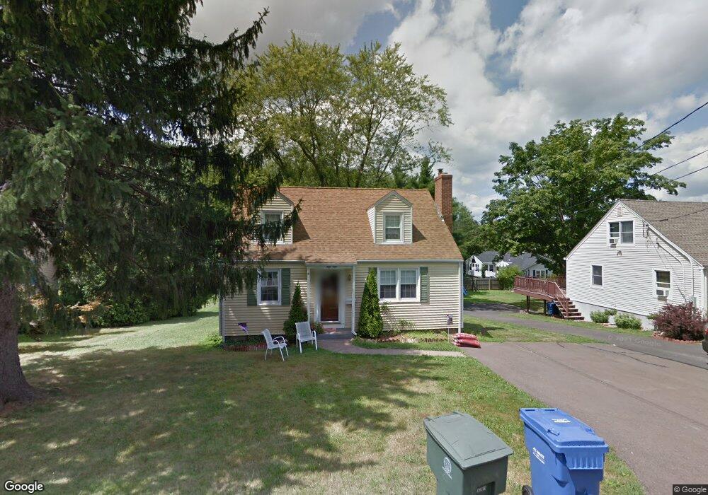
65 Lewis St Middletown, CT 06457
Estimated Value: $360,117 - $386,000
3
Beds
2
Baths
1,426
Sq Ft
$261/Sq Ft
Est. Value
About This Home
This home is located at 65 Lewis St, Middletown, CT 06457 and is currently estimated at $372,779, approximately $261 per square foot. 65 Lewis St is a home located in Middlesex County with nearby schools including Farm Hill School, St John Paul II School, and The Independent Day School.
Ownership History
Date
Name
Owned For
Owner Type
Purchase Details
Closed on
Apr 5, 2013
Sold by
Otfinoski Carl J and Otfinoski Lorraine M
Bought by
Otfinoski Ft and Otfinoski Carl J
Current Estimated Value
Purchase Details
Closed on
Sep 1, 1964
Bought by
Otfinoski Lorraine M
Create a Home Valuation Report for This Property
The Home Valuation Report is an in-depth analysis detailing your home's value as well as a comparison with similar homes in the area
Home Values in the Area
Average Home Value in this Area
Purchase History
| Date | Buyer | Sale Price | Title Company |
|---|---|---|---|
| Otfinoski Ft | -- | -- | |
| Otfinoski Lorraine M | -- | -- |
Source: Public Records
Mortgage History
| Date | Status | Borrower | Loan Amount |
|---|---|---|---|
| Previous Owner | Otfinoski Lorraine M | $15,500 |
Source: Public Records
Tax History Compared to Growth
Tax History
| Year | Tax Paid | Tax Assessment Tax Assessment Total Assessment is a certain percentage of the fair market value that is determined by local assessors to be the total taxable value of land and additions on the property. | Land | Improvement |
|---|---|---|---|---|
| 2025 | $6,041 | $163,220 | $62,170 | $101,050 |
| 2024 | $5,780 | $163,220 | $62,170 | $101,050 |
| 2023 | $5,486 | $163,220 | $62,170 | $101,050 |
| 2022 | $4,890 | $118,540 | $41,450 | $77,090 |
| 2021 | $4,869 | $118,540 | $41,450 | $77,090 |
| 2020 | $4,860 | $118,540 | $41,450 | $77,090 |
| 2019 | $4,884 | $118,540 | $41,450 | $77,090 |
| 2018 | $4,716 | $118,540 | $41,450 | $77,090 |
| 2017 | $4,786 | $123,730 | $47,760 | $75,970 |
| 2016 | $4,690 | $123,730 | $47,760 | $75,970 |
| 2015 | $4,586 | $123,730 | $47,760 | $75,970 |
| 2014 | $4,582 | $123,730 | $47,760 | $75,970 |
Source: Public Records
Map
Nearby Homes
- 347 Farm Hill Rd
- 0 Arbutus St Unit 24065180
- 77 Lindsey Rd
- 50 Garfield Ave
- 44 Trailside Crossing
- 73 Durant St
- 66 Durant Terrace
- 58 Durant Terrace
- 154 Front St
- 1 Russell St Unit 15
- 1 Russell St Unit 11
- 4 Hillside Ct
- 10 Lorelei Cir
- 55 Lorelei Cir
- 56 Bidwell Terrace
- 498 Pine St
- 128 Highland Ave
- 37 Front St
- 15 Kent Ct
- 42 Saybrook Rd