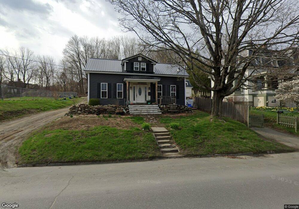
65 Main St Dexter, ME 04930
Estimated Value: $163,000 - $224,000
2
Beds
2
Baths
1,146
Sq Ft
$161/Sq Ft
Est. Value
About This Home
This home is located at 65 Main St, Dexter, ME 04930 and is currently estimated at $183,988, approximately $160 per square foot. 65 Main St is a home located in Penobscot County with nearby schools including Ridge View Community School, Dexter Regional High School, and Dexter Christian Academy.
Ownership History
Date
Name
Owned For
Owner Type
Purchase Details
Closed on
Jun 5, 2019
Sold by
Irish Tricia L
Bought by
Irish Tricia L and Irish Cody W
Current Estimated Value
Home Financials for this Owner
Home Financials are based on the most recent Mortgage that was taken out on this home.
Original Mortgage
$99,500
Outstanding Balance
$87,660
Interest Rate
4.2%
Mortgage Type
Stand Alone Refi Refinance Of Original Loan
Estimated Equity
$96,328
Purchase Details
Closed on
Jun 8, 2015
Sold by
Dexter Town Of
Bought by
Mccarthy Ronald S and Mccarthy Tricia L
Purchase Details
Closed on
May 2, 2014
Sold by
Dexter Town Of
Bought by
Mccarthy Ronald S and Mccarthy Tricia L
Purchase Details
Closed on
Feb 22, 2011
Sold by
Huuskonen Nyrik T and Huuskonen Linda I
Bought by
Mccarthy Ronald S and Mccarthy Tricia L
Purchase Details
Closed on
May 27, 2005
Sold by
Hall John L and Hall Heidi S
Bought by
Huuskonen Nyrik T and Huuskonen Linda I
Create a Home Valuation Report for This Property
The Home Valuation Report is an in-depth analysis detailing your home's value as well as a comparison with similar homes in the area
Home Values in the Area
Average Home Value in this Area
Purchase History
| Date | Buyer | Sale Price | Title Company |
|---|---|---|---|
| Irish Tricia L | -- | -- | |
| Irish Tricia L | -- | -- | |
| Mccarthy Ronald S | -- | -- | |
| Mccarthy Ronald S | -- | -- | |
| Mccarthy Ronald S | -- | -- | |
| Mccarthy Ronald S | -- | -- | |
| Mccarthy Ronald S | -- | -- | |
| Mccarthy Ronald S | -- | -- | |
| Huuskonen Nyrik T | -- | -- | |
| Huuskonen Nyrik T | -- | -- |
Source: Public Records
Mortgage History
| Date | Status | Borrower | Loan Amount |
|---|---|---|---|
| Open | Irish Tricia L | $99,500 | |
| Closed | Irish Tricia L | $99,500 |
Source: Public Records
Tax History
| Year | Tax Paid | Tax Assessment Tax Assessment Total Assessment is a certain percentage of the fair market value that is determined by local assessors to be the total taxable value of land and additions on the property. | Land | Improvement |
|---|---|---|---|---|
| 2024 | $2,242 | $114,400 | $13,400 | $101,000 |
| 2023 | $2,254 | $114,400 | $13,400 | $101,000 |
| 2022 | $2,264 | $113,200 | $12,200 | $101,000 |
| 2021 | $2,219 | $113,200 | $12,200 | $101,000 |
| 2020 | $2,219 | $113,200 | $12,200 | $101,000 |
| 2019 | $1,870 | $95,400 | $12,200 | $83,200 |
| 2018 | $1,545 | $95,400 | $12,200 | $83,200 |
| 2017 | $1,520 | $95,400 | $12,200 | $83,200 |
| 2016 | $1,774 | $95,400 | $12,200 | $83,200 |
| 2015 | $1,774 | $95,400 | $12,200 | $83,200 |
| 2014 | -- | $95,400 | $12,200 | $83,200 |
Source: Public Records
Map
Nearby Homes
Your Personal Tour Guide
Ask me questions while you tour the home.