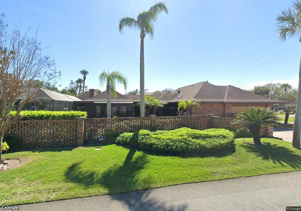
65 Riverside Dr Ormond Beach, FL 32176
Estimated Value: $821,000 - $1,216,000
4
Beds
3
Baths
3,572
Sq Ft
$298/Sq Ft
Est. Value
About This Home
This home is located at 65 Riverside Dr, Ormond Beach, FL 32176 and is currently estimated at $1,064,572, approximately $298 per square foot. 65 Riverside Dr is a home located in Volusia County with nearby schools including Ormond Beach Middle School, Seabreeze High School, and St Brendan Catholic School.
Ownership History
Date
Name
Owned For
Owner Type
Purchase Details
Closed on
Feb 3, 2003
Sold by
Drymonis Elias and Drymonis Lisa
Bought by
Drymonis Lisa and Drymonis Velouditsa
Current Estimated Value
Purchase Details
Closed on
Dec 20, 2002
Sold by
Drymonis Elias and Drymonis Lisa
Bought by
Drymonis Lisa
Purchase Details
Closed on
Sep 15, 1981
Bought by
Drymonis Lisa
Purchase Details
Closed on
Feb 15, 1969
Bought by
Drymonis Lisa
Create a Home Valuation Report for This Property
The Home Valuation Report is an in-depth analysis detailing your home's value as well as a comparison with similar homes in the area
Home Values in the Area
Average Home Value in this Area
Purchase History
| Date | Buyer | Sale Price | Title Company |
|---|---|---|---|
| Drymonis Lisa | -- | -- | |
| Drymonis Lisa | -- | -- | |
| Drymonis Lisa | $40,000 | -- | |
| Drymonis Lisa | $37,500 | -- |
Source: Public Records
Tax History
| Year | Tax Paid | Tax Assessment Tax Assessment Total Assessment is a certain percentage of the fair market value that is determined by local assessors to be the total taxable value of land and additions on the property. | Land | Improvement |
|---|---|---|---|---|
| 2026 | $6,398 | $445,101 | -- | -- |
| 2025 | $6,398 | $433,400 | -- | -- |
| 2024 | $5,996 | $421,186 | -- | -- |
| 2023 | $5,996 | $408,919 | $0 | $0 |
| 2022 | $5,823 | $397,009 | $0 | $0 |
| 2021 | $6,048 | $385,446 | $0 | $0 |
| 2020 | $5,959 | $380,124 | $0 | $0 |
| 2019 | $5,861 | $371,578 | $0 | $0 |
| 2018 | $5,896 | $364,650 | $0 | $0 |
| 2017 | $6,021 | $357,150 | $0 | $0 |
| 2016 | $6,105 | $349,804 | $0 | $0 |
| 2015 | $6,304 | $347,372 | $0 | $0 |
| 2014 | $6,266 | $344,615 | $0 | $0 |
Source: Public Records
Map
Nearby Homes
- 39 Willis Dr
- 65 Seton Trail Unit 8
- 1 John Anderson Dr Unit 205
- 1 John Anderson Dr Unit 604
- 1 John Anderson Dr Unit 303
- 1 John Anderson Dr Unit 3010
- 1 John Anderson Dr Unit 4120
- 1 John Anderson Dr Unit 301
- 1 John Anderson Dr Unit 412
- 156 Bosarvey Dr
- 65 Coquina Dr
- 84 N Halifax Dr
- 105 John Anderson Dr
- 114 N Halifax Dr
- 111 S Atlantic Ave Unit 702
- 111 S Atlantic Ave Unit 1104
- 89 S Atlantic Ave Unit 401
- 89 S Atlantic Ave Unit 204
- 89 S Atlantic Ave Unit 404
- 89 S Atlantic Ave Unit 1006
- 71 Riverside Dr
- 87 Riverside Dr
- 40 Riverside Dr
- 70 Riverside Dr
- 82 S Halifax Dr
- 70 S Halifax Dr
- 64 S Halifax Dr
- 76 S Halifax Dr
- 25 Bosarvey Cir
- 90 Riverside Dr
- 105 Riverside Dr
- 88 S Halifax Dr
- 49 Bosarvey Cir
- 108 Riverside Dr
- 115 Riverside Dr
- 30 Bosarvey Cir
- 59 Bosarvey Cir
- 110 Riverside Dr
- 40 Bosarvey Cir
- 63 S Halifax Dr
Your Personal Tour Guide
Ask me questions while you tour the home.