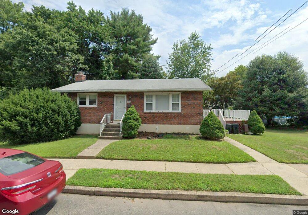
650 4th Ave Essington, PA 19029
Estimated Value: $232,000 - $287,312
2
Beds
2
Baths
962
Sq Ft
$261/Sq Ft
Est. Value
About This Home
This home is located at 650 4th Ave, Essington, PA 19029 and is currently estimated at $251,078, approximately $260 per square foot. 650 4th Ave is a home located in Delaware County with nearby schools including Interboro Senior High School.
Ownership History
Date
Name
Owned For
Owner Type
Purchase Details
Closed on
Nov 2, 2022
Sold by
Sworob Elaine J
Bought by
Sworob Nicholas
Current Estimated Value
Home Financials for this Owner
Home Financials are based on the most recent Mortgage that was taken out on this home.
Original Mortgage
$225,000
Outstanding Balance
$217,965
Interest Rate
7.08%
Estimated Equity
$33,113
Purchase Details
Closed on
Oct 9, 1984
Sold by
Sworob John
Bought by
Sworob John and Sworob Elaine J
Create a Home Valuation Report for This Property
The Home Valuation Report is an in-depth analysis detailing your home's value as well as a comparison with similar homes in the area
Home Values in the Area
Average Home Value in this Area
Purchase History
| Date | Buyer | Sale Price | Title Company |
|---|---|---|---|
| Sworob Nicholas | $250,000 | -- | |
| Sworob John | -- | -- |
Source: Public Records
Mortgage History
| Date | Status | Borrower | Loan Amount |
|---|---|---|---|
| Open | Sworob Nicholas | $225,000 |
Source: Public Records
Tax History Compared to Growth
Tax History
| Year | Tax Paid | Tax Assessment Tax Assessment Total Assessment is a certain percentage of the fair market value that is determined by local assessors to be the total taxable value of land and additions on the property. | Land | Improvement |
|---|---|---|---|---|
| 2025 | $4,148 | $131,230 | $32,270 | $98,960 |
| 2024 | $4,148 | $131,230 | $32,270 | $98,960 |
| 2023 | $4,079 | $131,230 | $32,270 | $98,960 |
| 2022 | $4,004 | $131,230 | $32,270 | $98,960 |
| 2021 | $5,930 | $131,230 | $32,270 | $98,960 |
| 2020 | $3,246 | $69,000 | $23,050 | $45,950 |
| 2019 | $3,240 | $69,000 | $23,050 | $45,950 |
| 2018 | $3,177 | $69,000 | $0 | $0 |
| 2017 | $3,100 | $69,000 | $0 | $0 |
| 2016 | $379 | $69,000 | $0 | $0 |
| 2015 | $386 | $69,000 | $0 | $0 |
| 2014 | $379 | $69,000 | $0 | $0 |
Source: Public Records
Map
Nearby Homes
- 210 Powhattan Ave
- 125 S Governor Printz Blvd
- 436 Manhattan St
- 69 Martin Ln
- 536 E Winona Ave
- 1062 Taylor Dr
- 508 E Winona Ave
- 307 Jansen Ave
- 512 Essex Rd
- 1158 Taylor Dr
- 231 Bartram Ave
- 229 Saude Ave
- 20 Martin Ln
- 403 Printz Ave
- 952 Grant Rd
- 810 Bennington Rd
- 1946 Carter Rd
- 207 Carre Ave
- 120 Bartram Ave
- 784 Bennington Rd