


650 Laurel Rd New Canaan, CT 06840
Estimated payment $16,561/month
Highlights
- Water Views
- Heated In Ground Pool
- Sub-Zero Refrigerator
- East Elementary School Rated A+
- Home fronts a pond
- 4.13 Acre Lot
About This Home
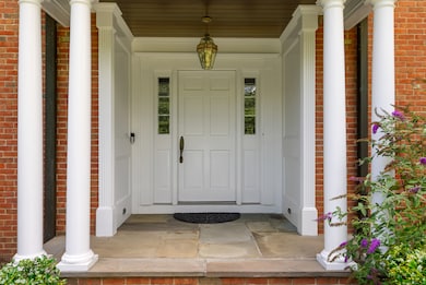
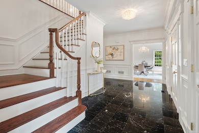
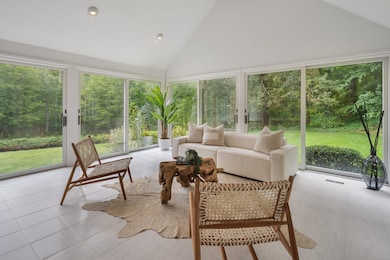
Through stone columns along a scenic approach is this first time on market custom-built five bedroom brick house on four private acres. Spacious rooms with 10ft ceilings and detailed mill work on the main floor include a cathedral height family room with dramatic fireplace, a front-to-back living room, a wood paneled office, and a four-season sun room to enjoy the stunning property. The large bonus room with bath and hardwood floors has just been approved as a fifth bedroom and is large enough to be divided into a bedroom and second office, playroom, or sitting room. The custom wood-paneled kitchen overlooking a natural setting has top quality appliances. The property includes a fenced pool, flat lawns on two levels, and a man made pond for skating and fishing. The lower level has a marvelous game room with wet bar, a full bath, a gym, and a large cedar closet. The landscaping is lovely without being high maintenance. A private patio outside the kitchen and family room is convenient to the pool and is the perfect place to grill. The pool has recently been refinished, the driveway refinished, and the pond dredged. Electric on the property is buried.The 3-car garage has high ceilings, good storage and a separate entry pad for each door. Move in and live comfortably or customize this stately home. An amazing opportunity.
Listing Agent
William Pitt Sotheby's Int'l Brokerage Phone: (203) 918-4452 License #RES.0784934 Listed on: 09/12/2025

Home Details
Home Type
- Single Family
Est. Annual Taxes
- $18,827
Year Built
- Built in 1988
Lot Details
- 4.13 Acre Lot
- Home fronts a pond
- Stone Wall
- Property is zoned 4AC
Home Design
- Colonial Architecture
- Brick Exterior Construction
- Concrete Foundation
- Frame Construction
- Asphalt Shingled Roof
- Masonry Siding
Interior Spaces
- 3 Fireplaces
- Water Views
- Partially Finished Basement
- Basement Fills Entire Space Under The House
- Home Security System
- Laundry on lower level
Kitchen
- Built-In Oven
- Cooktop
- Sub-Zero Refrigerator
- Dishwasher
- Compactor
Bedrooms and Bathrooms
- 5 Bedrooms
Attic
- Pull Down Stairs to Attic
- Unfinished Attic
Parking
- 3 Car Garage
- Automatic Garage Door Opener
Pool
- Heated In Ground Pool
- Gunite Pool
- Fence Around Pool
Outdoor Features
- Patio
Schools
- East Elementary School
- Saxe Middle School
- New Canaan High School
Utilities
- Zoned Heating and Cooling
- Heating System Uses Oil
- Underground Utilities
- Private Company Owned Well
- Electric Water Heater
- Fuel Tank Located in Basement
- Cable TV Available
Listing and Financial Details
- Assessor Parcel Number 187484
Map
Home Values in the Area
Average Home Value in this Area
Tax History
| Year | Tax Paid | Tax Assessment Tax Assessment Total Assessment is a certain percentage of the fair market value that is determined by local assessors to be the total taxable value of land and additions on the property. | Land | Improvement |
|---|---|---|---|---|
| 2025 | $18,827 | $1,128,050 | $588,000 | $540,050 |
| 2024 | $18,207 | $1,128,050 | $588,000 | $540,050 |
| 2023 | $18,057 | $953,400 | $572,740 | $380,660 |
| 2022 | $17,514 | $953,400 | $572,740 | $380,660 |
| 2021 | $17,314 | $953,400 | $572,740 | $380,660 |
| 2020 | $17,314 | $953,400 | $572,740 | $380,660 |
| 2019 | $17,390 | $953,400 | $572,740 | $380,660 |
| 2018 | $18,428 | $1,086,540 | $466,200 | $620,340 |
| 2017 | $18,113 | $1,086,540 | $466,200 | $620,340 |
| 2016 | $17,721 | $1,086,540 | $466,200 | $620,340 |
| 2015 | $17,993 | $1,086,540 | $466,200 | $620,340 |
| 2014 | $16,885 | $1,086,540 | $466,200 | $620,340 |
Property History
| Date | Event | Price | List to Sale | Price per Sq Ft |
|---|---|---|---|---|
| 11/20/2025 11/20/25 | Pending | -- | -- | -- |
| 09/12/2025 09/12/25 | For Sale | $2,850,000 | -- | $464 / Sq Ft |
Purchase History
| Date | Type | Sale Price | Title Company |
|---|---|---|---|
| Quit Claim Deed | -- | -- | |
| Quit Claim Deed | -- | -- | |
| Quit Claim Deed | -- | -- | |
| Deed | $20,800 | -- |
Mortgage History
| Date | Status | Loan Amount | Loan Type |
|---|---|---|---|
| Previous Owner | $650,000 | No Value Available |
Source: SmartMLS
MLS Number: 24117341
APN: NCAN-000040-000101-000003
Disclaimer: Certain information contained herein is derived from information provided by parties other than Homes.com. All information provided is deemed reliable, but is not guaranteed to be accurate and should be independently verified.
![]() IDX information is provided exclusively for personal, non-commercial use, and may not be used for any purpose other than to identify prospective properties consumers may be interested in purchasing. Information is deemed reliable but not guaranteed.
IDX information is provided exclusively for personal, non-commercial use, and may not be used for any purpose other than to identify prospective properties consumers may be interested in purchasing. Information is deemed reliable but not guaranteed.
- 22 Father Peters Ln
- 469, 531,533 N Wilton Rd
- 469L N Wilton Rd
- 531L N Wilton Rd
- 533L N Wilton Rd
- 62 Summersweet Ln
- 44 Benedict Hill Rd
- 760 Valley Rd
- 1247 Oenoke Ridge
- 37 East St
- 122 Brookwood Ln
- 439 Cheese Spring Rd
- 48 Brookwood Ln
- 199 Mariomi Rd
- 114 Ferris Hill Rd
- 176 Logan Rd
- 26 Ledgewood Dr
- 565 Oenoke Ridge
- 30 Wild Duck Rd
- 240 Rosebrook Rd