
Seller's Agent in 2025
Leslie Hammond
Hammond Realty LLC
(860) 205-4552
2 in this area
46 Total Sales
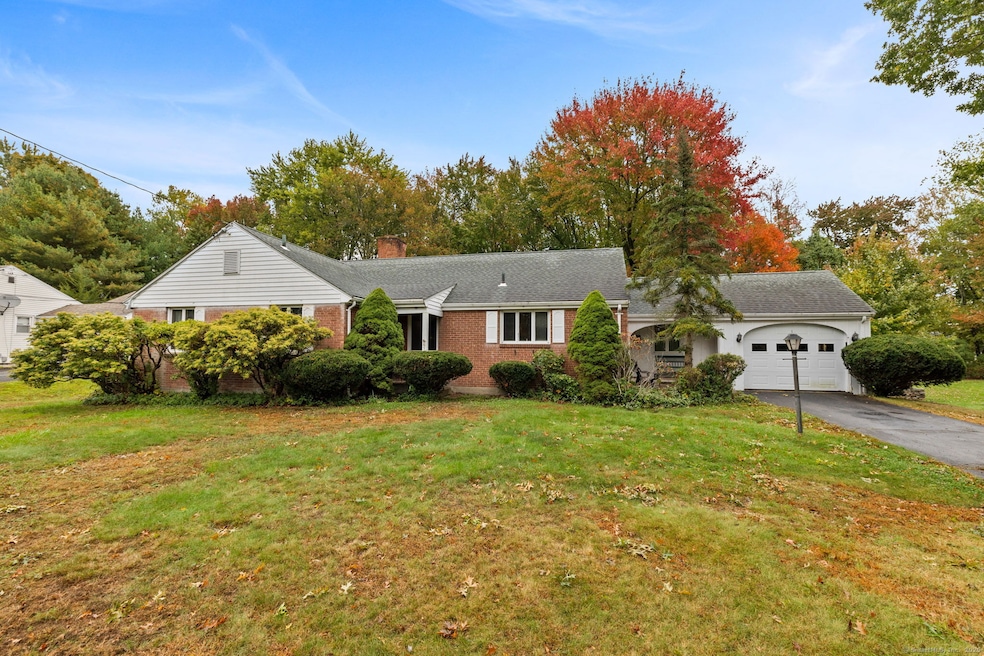
Welcome home to this inviting 3-bedroom, 1.1-bath brick ranch offering over 1,800 sq. ft. of light-filled living space and an attached 1-car garage. Beautiful hardwood floors and classic wood trim flow throughout the open floor plan; classic built-ins frame the fireplaced living room. Sunlight pours in through the picture windows in both the living room and sunroom, showcasing views of the private, tree-lined backyard filled with mature perennials. The sunroom, accessible from the dining room, is perfect for year-round enjoyment and entertaining. A spacious eat-in kitchen provides abundant cabinetry and counter space-ideal for cooking, baking, and casual meals. Two generously sized bedrooms at the rear of the home share a full bath, while the third bedroom, located just off the dining room, offers privacy and flexibility for use as a home office, guest room, or den. The full heated basement, spanning the entire footprint of the home, presents exciting opportunities for future expansion-a recreation room, hobby area, gym, or additional living space. Thoughtful touches include overhead lighting in every room. Recent updates include a newer high-efficiency boiler and a 10-year-old, one-layer roof, ensuring comfort and peace of mind. This well-maintained home combines the best of both worlds: a peaceful retreat surrounded by nature, yet conveniently close to shopping, restaurants, and everyday amenities.
Last Agent to Sell the Property
Hammond Realty LLC Brokerage Phone: (860) 205-4552 License #REB.0789948 Listed on: 10/16/2025
| Date | Type | Sale Price | Title Company |
|---|---|---|---|
| Warranty Deed | $380,000 | -- | |
| Quit Claim Deed | -- | None Available | |
| Quit Claim Deed | -- | None Available | |
| Quit Claim Deed | -- | -- | |
| Warranty Deed | $150,000 | -- |
| Date | Status | Loan Amount | Loan Type |
|---|---|---|---|
| Previous Owner | $152,317 | Stand Alone Refi Refinance Of Original Loan | |
| Previous Owner | $150,000 | No Value Available | |
| Previous Owner | $120,000 | Purchase Money Mortgage |
| Date | Event | Price | List to Sale | Price per Sq Ft |
|---|---|---|---|---|
| 12/04/2025 12/04/25 | Sold | $380,000 | 0.0% | $207 / Sq Ft |
| 11/12/2025 11/12/25 | Pending | -- | -- | -- |
| 11/07/2025 11/07/25 | Off Market | $380,000 | -- | -- |
| 10/16/2025 10/16/25 | For Sale | $399,900 | -- | $218 / Sq Ft |
| Year | Tax Paid | Tax Assessment Tax Assessment Total Assessment is a certain percentage of the fair market value that is determined by local assessors to be the total taxable value of land and additions on the property. | Land | Improvement |
|---|---|---|---|---|
| 2025 | $10,179 | $246,950 | $94,370 | $152,580 |
| 2024 | $7,169 | $165,880 | $68,550 | $97,330 |
| 2023 | $6,930 | $165,880 | $68,550 | $97,330 |
| 2022 | $6,814 | $165,880 | $68,550 | $97,330 |
| 2021 | $6,746 | $165,880 | $68,550 | $97,330 |
| 2020 | $6,750 | $165,880 | $68,550 | $97,330 |
| 2019 | $6,758 | $165,880 | $68,550 | $97,330 |
| 2018 | $6,908 | $169,400 | $66,400 | $103,000 |
| 2017 | $6,737 | $169,400 | $66,400 | $103,000 |
| 2016 | $6,529 | $169,400 | $66,400 | $103,000 |
| 2015 | $6,469 | $169,400 | $66,400 | $103,000 |
| 2014 | $6,224 | $169,400 | $66,400 | $103,000 |
Seller's Agent in 2025
Leslie Hammond
Hammond Realty LLC
(860) 205-4552
2 in this area
46 Total Sales
Buyer's Agent in 2025
Jenny Kwok
Berkshire Hathaway Home Services
(860) 938-9888
1 in this area
8 Total Sales
Source: SmartMLS
MLS Number: 24133917
APN: WETH-000195-000000-000030
Disclaimer: Certain information contained herein is derived from information provided by parties other than Homes.com. All information provided is deemed reliable, but is not guaranteed to be accurate and should be independently verified.
![]() IDX information is provided exclusively for personal, non-commercial use, and may not be used for any purpose other than to identify prospective properties consumers may be interested in purchasing. Information is deemed reliable but not guaranteed.
IDX information is provided exclusively for personal, non-commercial use, and may not be used for any purpose other than to identify prospective properties consumers may be interested in purchasing. Information is deemed reliable but not guaranteed.
Ask me questions while you tour the home.