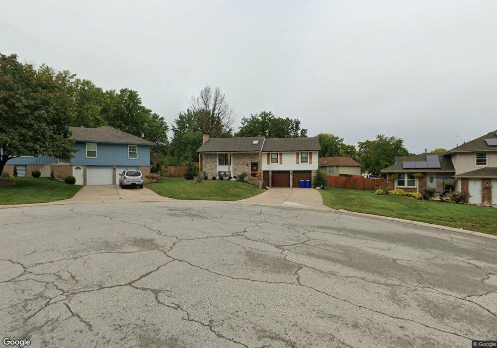
6502 Yorkshire Ct Grandview, MO 64030
Estimated Value: $250,000 - $313,000
3
Beds
3
Baths
1,400
Sq Ft
$198/Sq Ft
Est. Value
About This Home
This home is located at 6502 Yorkshire Ct, Grandview, MO 64030 and is currently estimated at $277,205, approximately $198 per square foot. 6502 Yorkshire Ct is a home located in Jackson County with nearby schools including Meadowmere Elementary School, Grandview Middle, and Grandview High School.
Ownership History
Date
Name
Owned For
Owner Type
Purchase Details
Closed on
Feb 23, 2022
Sold by
Verhulst Kevin E and Verhulst Linda E
Bought by
Vigh Ron and Vigh Jackie
Current Estimated Value
Home Financials for this Owner
Home Financials are based on the most recent Mortgage that was taken out on this home.
Original Mortgage
$212,000
Outstanding Balance
$196,858
Interest Rate
3.55%
Mortgage Type
New Conventional
Estimated Equity
$80,347
Purchase Details
Closed on
Apr 29, 2021
Sold by
Storms Kyra
Bought by
Verhuist Kevin
Create a Home Valuation Report for This Property
The Home Valuation Report is an in-depth analysis detailing your home's value as well as a comparison with similar homes in the area
Home Values in the Area
Average Home Value in this Area
Purchase History
| Date | Buyer | Sale Price | Title Company |
|---|---|---|---|
| Vigh Ron | -- | Thomson Affinity Title | |
| Vigh Ron | $281,960 | Thomson Affinity Title | |
| Verhuist Kevin | -- | Thomson Affinity Title |
Source: Public Records
Mortgage History
| Date | Status | Borrower | Loan Amount |
|---|---|---|---|
| Open | Vigh Ron | $212,000 | |
| Closed | Vigh Ron | $212,000 |
Source: Public Records
Tax History
| Year | Tax Paid | Tax Assessment Tax Assessment Total Assessment is a certain percentage of the fair market value that is determined by local assessors to be the total taxable value of land and additions on the property. | Land | Improvement |
|---|---|---|---|---|
| 2025 | $3,708 | $33,670 | $6,112 | $27,558 |
| 2024 | $3,645 | $45,604 | $4,594 | $41,010 |
| 2023 | $3,645 | $45,603 | $7,136 | $38,467 |
| 2022 | $2,186 | $25,460 | $5,900 | $19,560 |
| 2021 | $2,184 | $25,460 | $5,900 | $19,560 |
| 2020 | $1,970 | $24,321 | $5,900 | $18,421 |
| 2019 | $2,033 | $26,035 | $5,900 | $20,135 |
| 2018 | $2,121 | $25,265 | $4,434 | $20,831 |
| 2016 | $2,111 | $24,632 | $3,981 | $20,651 |
Source: Public Records
Map
Nearby Homes
- 12217 Bennington Ave
- 13218 Craig Ave
- 6712 E 134th St
- 13420 Belmead Ave
- 12200 Craig Dr
- 13424 Parker Ave
- 13408 Bristol Ave
- 14925 S U S 71 Hwy
- 12825 Winchester Ave
- 6104 E 136th St
- 6008 E 129th St
- 6105 E 136th St
- 6614 E 128th St
- 12709 Applewood Dr
- 5956 E 129th St
- 7601 High Grove Rd
- 7507 E 133rd St
- 12701 Applewood Dr
- 12801 Corrington Ave
- 12800 Crystal Ave
- 6504 Yorkshire Ct
- 6500 Yorkshire Ct
- 6501 Yorkshire Ct
- 6503 Brentwood Ct
- 6503 Yorkshire Ct
- 6505 Brentwood Ct
- 6505 Yorkshire Ct
- 6507 Yorkshire Ct
- 6501 Brentwood Ct
- 6507 Brentwood Ct
- 13119 Fuller Ave
- 13007 Bennington Ave
- 13049 Bennington Ave
- 6500 Brentwood Ct
- 13115 Fuller Ave
- 13123 Fuller Ave
- 13005 Bennington Ave
- 6502 Berkshire Ct
- 6502 Brentwood Ct
- 6506 Brentwood Ct
Your Personal Tour Guide
Ask me questions while you tour the home.