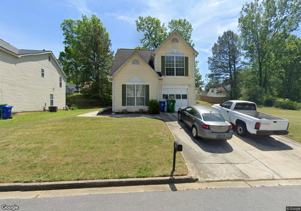
6509 Alford Way Lithonia, GA 30058
Estimated Value: $242,153 - $266,000
3
Beds
3
Baths
1,366
Sq Ft
$186/Sq Ft
Est. Value
About This Home
This home is located at 6509 Alford Way, Lithonia, GA 30058 and is currently estimated at $253,788, approximately $185 per square foot. 6509 Alford Way is a home located in DeKalb County with nearby schools including Pine Ridge Elementary School, Stephenson Middle School, and Stephenson High School.
Ownership History
Date
Name
Owned For
Owner Type
Purchase Details
Closed on
Jan 5, 2010
Sold by
Wells Fargo Bk Na
Bought by
Federal Home Loan Mortgage Corporation
Current Estimated Value
Purchase Details
Closed on
Apr 24, 1995
Sold by
Diversified Shelter Group Ltd
Bought by
Tibbs William L
Create a Home Valuation Report for This Property
The Home Valuation Report is an in-depth analysis detailing your home's value as well as a comparison with similar homes in the area
Home Values in the Area
Average Home Value in this Area
Purchase History
| Date | Buyer | Sale Price | Title Company |
|---|---|---|---|
| Federal Home Loan Mortgage Corporation | -- | -- | |
| Wells Fargo Bk Na | $44,000 | -- | |
| Tibbs William L | $81,900 | -- |
Source: Public Records
Mortgage History
| Date | Status | Borrower | Loan Amount |
|---|---|---|---|
| Closed | Tibbs William L | $0 |
Source: Public Records
Tax History Compared to Growth
Tax History
| Year | Tax Paid | Tax Assessment Tax Assessment Total Assessment is a certain percentage of the fair market value that is determined by local assessors to be the total taxable value of land and additions on the property. | Land | Improvement |
|---|---|---|---|---|
| 2025 | $478 | $92,280 | $10,000 | $82,280 |
| 2024 | $466 | $83,400 | $10,000 | $73,400 |
| 2023 | $466 | $80,240 | $10,000 | $70,240 |
| 2022 | $1,429 | $46,680 | $5,135 | $41,545 |
| 2021 | $1,429 | $46,680 | $5,135 | $41,545 |
| 2020 | $1,272 | $46,680 | $5,280 | $41,400 |
| 2019 | $1,423 | $46,680 | $5,280 | $41,400 |
| 2018 | $1,621 | $43,400 | $5,280 | $38,120 |
| 2017 | $1,301 | $39,920 | $5,280 | $34,640 |
| 2016 | $1,222 | $37,640 | $5,280 | $32,360 |
| 2014 | $1,766 | $31,120 | $5,280 | $25,840 |
Source: Public Records
Map
Nearby Homes
- 6543 Alford Way
- 6426 Alford Cir
- 6390 Alford Cir
- 1276 Huntington Place Cir
- 1124 Shady Creek Dr
- 6436 Valerie Bluff
- 6675 Princeton Park Ct
- 1246 Carriage Trace Cir
- 1001 Pine Ridge Dr
- 711 Ashley Ln
- 6536 Deshon Ct
- 860 Southland Pass
- 1213 Oak Knoll Ct
- 1174 Falkirk Ln
- 861 Southland Pass
- 6492 Swift Creek Rd
- 1286 Regal Heights Dr
- 812 Sweet Pine Brook
- 1148 Falkirk Ln
- 1086 Deshon Trail
- 6515 Alford Way Unit 2
- 1045 Crooked Creek Rd
- 1037 Crooked Creek Rd
- 6514 Alford Way
- 6521 Alford Way Unit 2
- 1053 Crooked Creek Rd
- 1031 Crooked Creek Rd
- 6520 Alford Way Unit 6520
- 6520 Alford Way Unit 2
- 6520 Alford Way
- 1023 Crooked Creek Rd
- 6508 Alford Way
- 6525 Alford Way
- 6524 Alford Way
- 1053 Huntington Place Cir
- 1052 Crooked Creek Rd
- 1057 Crooked Creek Rd
- 6500 Alford Way
- 6531 Alford Way
- 6485 Alford Way