6509 Old Harford Rd Baltimore, MD 21214
Westfield NeighborhoodEstimated Value: $215,490 - $335,000
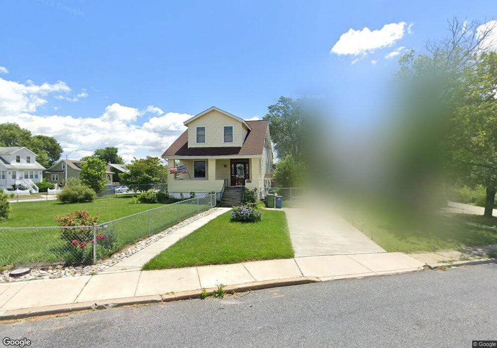
About This Home
This home is located at 6509 Old Harford Rd, Baltimore, MD 21214 and is currently estimated at $275,245, approximately $177 per square foot. 6509 Old Harford Rd is a home located in Baltimore City with nearby schools including Hamilton Elementary Middle School, Booker T. Washington Middle School, and Paul Laurence Dunbar High School.
Ownership History
We collect this data history from publicly available records. To have your information removed, we recommend requesting removal directly through your county’s website.
Purchase Details
Home Financials for this Owner
Home Financials are based on the most recent Mortgage that was taken out on this home.Purchase Details
Home Values in the Area
Average Home Value in this Area
Purchase History
We collect this data history from publicly available records. To have your information removed, we recommend requesting removal directly through your county’s website.
| Date | Buyer | Sale Price | Title Company |
|---|---|---|---|
| $160,000 | -- | ||
| -- | -- |
Mortgage History
We collect this data history from publicly available records. To have your information removed, we recommend requesting removal directly through your county’s website.
| Date | Status | Borrower | Loan Amount |
|---|---|---|---|
| Open | $138,380 |
Tax History
We collect this data history from publicly available records. To have your information removed, we recommend requesting removal directly through your county’s website.
| Year | Tax Paid | Tax Assessment Tax Assessment Total Assessment is a certain percentage of the fair market value that is determined by local assessors to be the total taxable value of land and additions on the property. | Land | Improvement |
|---|---|---|---|---|
| 2025 | $3,352 | $162,767 | -- | -- |
| 2024 | $3,352 | $153,900 | $52,400 | $101,500 |
| 2023 | $3,344 | $153,900 | $52,400 | $101,500 |
| 2022 | $3,351 | $153,900 | $52,400 | $101,500 |
| 2021 | $3,689 | $156,300 | $52,400 | $103,900 |
| 2020 | $3,160 | $149,267 | $0 | $0 |
| 2019 | $3,011 | $142,233 | $0 | $0 |
| 2018 | $2,984 | $135,200 | $52,400 | $82,800 |
| 2017 | $3,010 | $135,200 | $0 | $0 |
| 2016 | $3,544 | $135,200 | $0 | $0 |
| 2015 | $3,544 | $146,600 | $0 | $0 |
| 2014 | $3,544 | $146,600 | $0 | $0 |
Map
- 2803 Fleetwood Ave
- 2716 Westfield Ave
- 2809 E Northern Pkwy
- 6419 Marietta Ave
- 2827 Fleetwood Ave
- 2824 Fleetwood Ave
- 2808 Berwick Ave
- 2715 Louise Ave
- 2905 Westfield Ave
- 2507 E Northern Pkwy
- 2814 Hemlock Ave
- 2913 Fleetwood Ave
- 6600 Hampnett Ave
- 6307 Birchwood Ave
- 6410 Fair Oaks Ave
- 2910 Berwick Ave
- 2812 Kildaire Dr
- 2814 Kildaire Dr
- 2814 Chesley Ave
- 2915 Kildaire Dr
- 6511 Old Harford Rd
- 6507 Old Harford Rd
- 6507 Old Harford Rd Unit 1
- 2703 Fleetwood Ave
- 6505 Old Harford Rd
- 6505 Old Harford Rd Unit B
- 6503 Old Harford Rd
- 6503 Old Harford Rd
- 6503 Old Harford Rd Unit 1
- 2705 Fleetwood Ave
- 2700 Fleetwood Ave
- 2700 Fleetwood Ave
- 2702 Fleetwood Ave
- 6503 Old Harford Road -1 2
- 2707 Fleetwood Ave
- 2704 Fleetwood Ave
- 6508 Old Harford Rd
- 6501 Old Harford Rd
- 2706 Fleetwood Ave
- 6512 Harford Rd
Ask me questions while you tour the home.