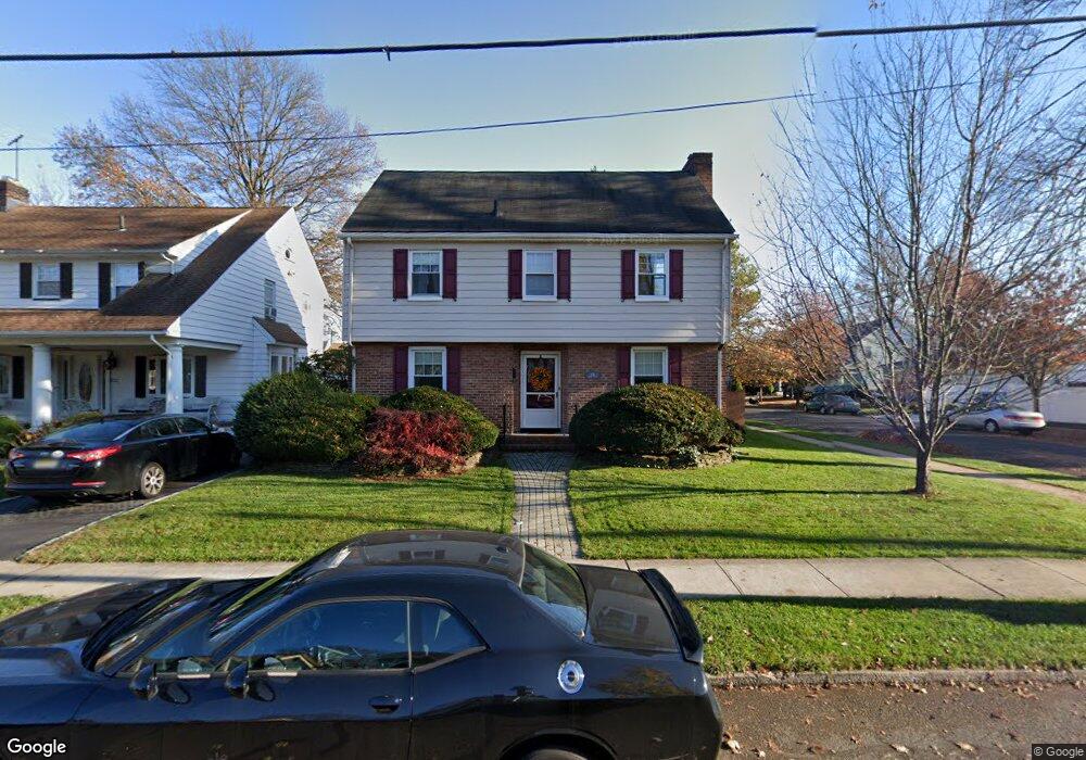
651 Bryant St Rahway, NJ 07065
Estimated Value: $498,204 - $644,000
Studio
--
Bath
1,705
Sq Ft
$327/Sq Ft
Est. Value
About This Home
This home is located at 651 Bryant St, Rahway, NJ 07065 and is currently estimated at $557,551, approximately $327 per square foot. 651 Bryant St is a home located in Union County with nearby schools including Rahway High School.
Ownership History
Date
Name
Owned For
Owner Type
Purchase Details
Closed on
Nov 15, 2021
Sold by
Christopher Christoph G
Bought by
Christopher Christoph G and Christopher Margaret A
Current Estimated Value
Purchase Details
Closed on
Feb 28, 2001
Sold by
Smith Sidney and Smith Pauline
Bought by
Christopher Christopher and Ruck Margaret
Home Financials for this Owner
Home Financials are based on the most recent Mortgage that was taken out on this home.
Original Mortgage
$148,000
Interest Rate
7%
Mortgage Type
Purchase Money Mortgage
Create a Home Valuation Report for This Property
The Home Valuation Report is an in-depth analysis detailing your home's value as well as a comparison with similar homes in the area
Home Values in the Area
Average Home Value in this Area
Purchase History
| Date | Buyer | Sale Price | Title Company |
|---|---|---|---|
| Christopher Christoph G | -- | None Listed On Document | |
| Christopher Christopher | $168,000 | Title Services |
Source: Public Records
Mortgage History
| Date | Status | Borrower | Loan Amount |
|---|---|---|---|
| Previous Owner | Christopher Christopher | $148,000 |
Source: Public Records
Tax History
| Year | Tax Paid | Tax Assessment Tax Assessment Total Assessment is a certain percentage of the fair market value that is determined by local assessors to be the total taxable value of land and additions on the property. | Land | Improvement |
|---|---|---|---|---|
| 2025 | $10,249 | $138,400 | $49,600 | $88,800 |
| 2024 | $9,926 | $138,400 | $49,600 | $88,800 |
| 2023 | $9,926 | $138,400 | $49,600 | $88,800 |
| 2022 | $9,718 | $138,400 | $49,600 | $88,800 |
| 2021 | $9,620 | $138,400 | $49,600 | $88,800 |
| 2020 | $9,584 | $138,400 | $49,600 | $88,800 |
| 2019 | $9,462 | $138,400 | $49,600 | $88,800 |
| 2018 | $9,263 | $138,400 | $49,600 | $88,800 |
| 2017 | $9,035 | $138,400 | $49,600 | $88,800 |
| 2016 | $8,842 | $138,400 | $49,600 | $88,800 |
| 2015 | $8,743 | $138,400 | $49,600 | $88,800 |
| 2014 | $8,586 | $138,400 | $49,600 | $88,800 |
Source: Public Records
Map
Nearby Homes
- 146 Forbes St
- 275 Forbes St
- 180 W Stearns St
- 59 Minna St
- 331 W Inman Ave
- 452 Jaques Ave
- 134 Stanton St
- 454 Stanley Place
- 325 Orchard St
- 460 Grove St
- 1016 Jaques Ave
- 593 W Hazelwood Ave
- 348 W Emerson Ave
- 688 W Lake Ave
- 698 W Lake Ave
- 693 Hemlock St
- 265 E Stearns St
- 197 Iva St
- 935 Thorn St
- 683 Maple Ave
Your Personal Tour Guide
Ask me questions while you tour the home.