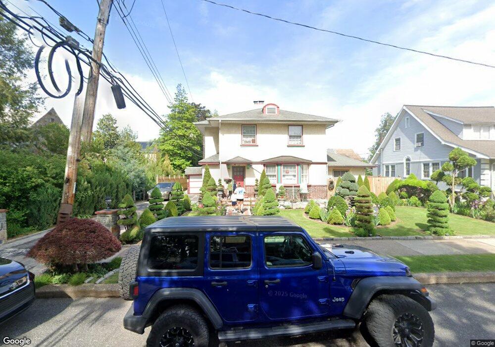
651 Fern St Lansdowne, PA 19050
Estimated Value: $283,200 - $325,000
3
Beds
2
Baths
1,874
Sq Ft
$159/Sq Ft
Est. Value
About This Home
This home is located at 651 Fern St, Lansdowne, PA 19050 and is currently estimated at $298,550, approximately $159 per square foot. 651 Fern St is a home located in Delaware County with nearby schools including Evans Elementary School, Penn Wood Middle School, and Penn Wood High School - Cypress Street Campus.
Ownership History
Date
Name
Owned For
Owner Type
Purchase Details
Closed on
Jun 13, 2005
Sold by
Nardi Carl N and Nardi Marie D
Bought by
Hourn Oll Sam and Chan Sokha
Current Estimated Value
Home Financials for this Owner
Home Financials are based on the most recent Mortgage that was taken out on this home.
Original Mortgage
$157,500
Outstanding Balance
$82,330
Interest Rate
5.78%
Mortgage Type
Fannie Mae Freddie Mac
Estimated Equity
$216,220
Create a Home Valuation Report for This Property
The Home Valuation Report is an in-depth analysis detailing your home's value as well as a comparison with similar homes in the area
Home Values in the Area
Average Home Value in this Area
Purchase History
| Date | Buyer | Sale Price | Title Company |
|---|---|---|---|
| Hourn Oll Sam | $175,000 | Liberty Abstract Of Delware |
Source: Public Records
Mortgage History
| Date | Status | Borrower | Loan Amount |
|---|---|---|---|
| Open | Hourn Oll Sam | $157,500 |
Source: Public Records
Tax History Compared to Growth
Tax History
| Year | Tax Paid | Tax Assessment Tax Assessment Total Assessment is a certain percentage of the fair market value that is determined by local assessors to be the total taxable value of land and additions on the property. | Land | Improvement |
|---|---|---|---|---|
| 2025 | $6,225 | $145,770 | $45,240 | $100,530 |
| 2024 | $6,225 | $145,770 | $45,240 | $100,530 |
| 2023 | $5,653 | $145,770 | $45,240 | $100,530 |
| 2022 | $5,390 | $145,770 | $45,240 | $100,530 |
| 2021 | $8,151 | $145,770 | $45,240 | $100,530 |
| 2020 | $5,832 | $93,380 | $26,120 | $67,260 |
| 2019 | $5,729 | $93,380 | $26,120 | $67,260 |
| 2018 | $5,649 | $93,380 | $0 | $0 |
| 2017 | $5,531 | $93,380 | $0 | $0 |
| 2016 | $512 | $93,380 | $0 | $0 |
| 2015 | $512 | $93,380 | $0 | $0 |
| 2014 | $512 | $93,380 | $0 | $0 |
Source: Public Records
Map
Nearby Homes
- 1016 Whitby Ave
- 536 Cypress St
- 740 Church Ln
- 813 Arbor Rd
- 702 Cedar Ave
- 711 Yeadon Ave Unit 1
- 825 Laurel Rd
- 722 Yeadon Ave
- 800 Bullock Ave
- 1104 Baily Rd
- 503 Bonsall Ave
- 537 Orchard Ave
- 435 Bonsall Ave
- 530 Orchard Ave
- 407 Church Ln
- 808 Serrill Ave
- 908 Yeadon Ave
- 6030 Cedarhurst St
- 921 Serrill Ave
- 6013 Baltimore Ave