Estimated Value: $191,000 - $250,014
4
Beds
2
Baths
1,504
Sq Ft
$143/Sq Ft
Est. Value
About This Home
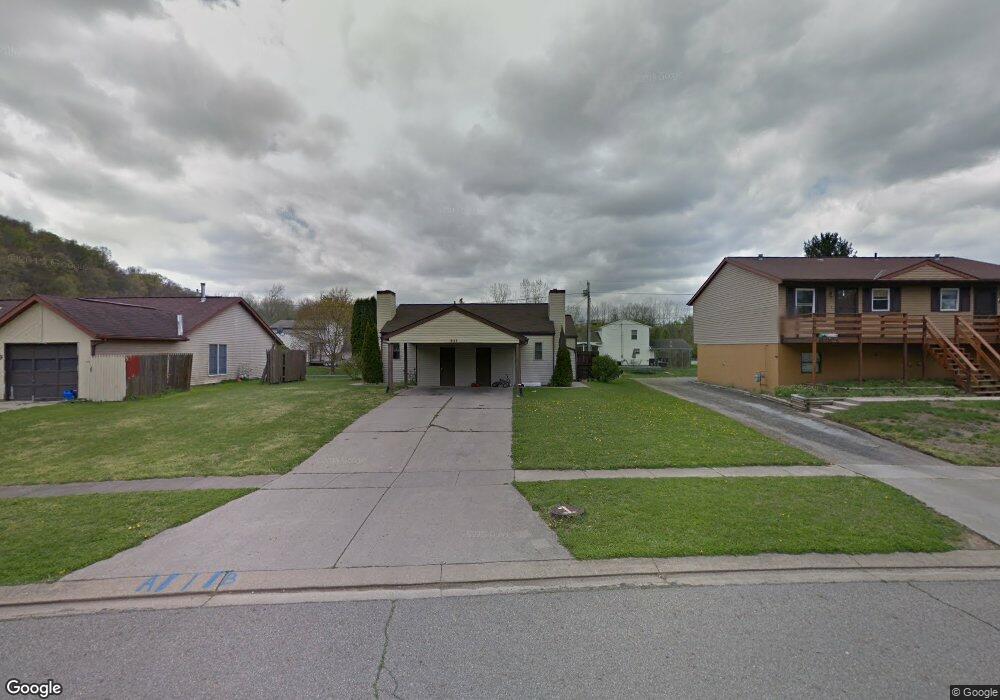
This home is located at 651 Huron Dr, Heath, OH 43056 and is currently estimated at $215,004, approximately $142 per square foot. 651 Huron Dr is a home located in Licking County with nearby schools including Garfield Elementary School, Stevenson Elementary School, and Heath Middle School.
Ownership History
Date
Name
Owned For
Owner Type
Purchase Details
Closed on
Jan 23, 2019
Sold by
Mckaig Mckaig Sue E Sue E
Bought by
Taylor Haley L and Taylor Barry M
Current Estimated Value
Home Financials for this Owner
Home Financials are based on the most recent Mortgage that was taken out on this home.
Original Mortgage
$95,200
Outstanding Balance
$72,547
Interest Rate
4.6%
Mortgage Type
Future Advance Clause Open End Mortgage
Estimated Equity
$142,457
Purchase Details
Closed on
Sep 23, 2014
Sold by
Mckaig Gary
Bought by
Mckaig Sue E and Mckaig Gary E
Purchase Details
Closed on
May 29, 2007
Sold by
Schoop David A and Schoop Deborah S
Bought by
Mckaig Gary
Purchase Details
Closed on
Nov 9, 1999
Sold by
Blust Donald C
Bought by
Schoop David A and Rogers Deborah S
Home Financials for this Owner
Home Financials are based on the most recent Mortgage that was taken out on this home.
Original Mortgage
$73,800
Interest Rate
7.78%
Mortgage Type
New Conventional
Create a Home Valuation Report for This Property
The Home Valuation Report is an in-depth analysis detailing your home's value as well as a comparison with similar homes in the area
Home Values in the Area
Average Home Value in this Area
Purchase History
| Date | Buyer | Sale Price | Title Company |
|---|---|---|---|
| Taylor Haley L | $112,000 | Chicago Title | |
| Mckaig Sue E | -- | None Available | |
| Mckaig Gary | $94,000 | Kent Tit | |
| Schoop David A | $82,000 | -- |
Source: Public Records
Mortgage History
| Date | Status | Borrower | Loan Amount |
|---|---|---|---|
| Open | Taylor Haley L | $95,200 | |
| Previous Owner | Schoop David A | $73,800 |
Source: Public Records
Tax History
| Year | Tax Paid | Tax Assessment Tax Assessment Total Assessment is a certain percentage of the fair market value that is determined by local assessors to be the total taxable value of land and additions on the property. | Land | Improvement |
|---|---|---|---|---|
| 2024 | $2,492 | $56,780 | $15,370 | $41,410 |
| 2023 | $2,760 | $56,780 | $15,370 | $41,410 |
| 2022 | $2,166 | $39,140 | $10,470 | $28,670 |
| 2021 | $2,211 | $39,140 | $10,470 | $28,670 |
| 2020 | $2,225 | $39,140 | $10,470 | $28,670 |
| 2019 | $2,163 | $38,680 | $8,720 | $29,960 |
| 2018 | $2,180 | $0 | $0 | $0 |
| 2017 | $2,179 | $0 | $0 | $0 |
| 2016 | $1,657 | $0 | $0 | $0 |
| 2015 | $843 | $0 | $0 | $0 |
| 2014 | $809 | $0 | $0 | $0 |
| 2013 | $801 | $0 | $0 | $0 |
Source: Public Records
Map
Nearby Homes
- 616 Huron Dr
- 233 Wildwood Ct Unit 233C
- 780 Fieldson Dr
- 567 Franklin Ave
- 231 Fieldpoint Rd
- 403 Laurel Oaks Ln Unit Lot 132
- 399 Laurel Oaks Ln Unit Lot 131
- 944 Fieldson Dr
- 381 Laurel Oaks Ln
- 164 Licking View Dr
- 953 Hopewell Heights Dr
- 602 Deanna Stroll Rd
- 224 Walden Rd
- 1285 Bluejack Ln
- 90 Franklin Ave
- 1265 Green Valley Dr
- 101 Fieldpoint Rd
- 514 S 30th St
- 18 Swainford Dr
- 452 Saint James Gate
- 659 Huron Dr
- 645 Huron Dr
- 645 Huron Dr Unit A&B
- 632 Livingston Ct
- 637 Huron Dr
- 634 Livingston Ct
- 630 Livingston Ct
- 636 Livingston Ct
- 631 Huron Dr
- 652 Huron Dr
- 660 Huron Dr
- 644 Huron Dr
- 627 Huron Dr
- 638 Livingston Ct
- 636 Huron Dr
- 628 Huron Dr
- 623 Huron Dr
- 633 Livingston Ct
- 635 Livingston Ct
- 640 Livingston Ct
Your Personal Tour Guide
Ask me questions while you tour the home.