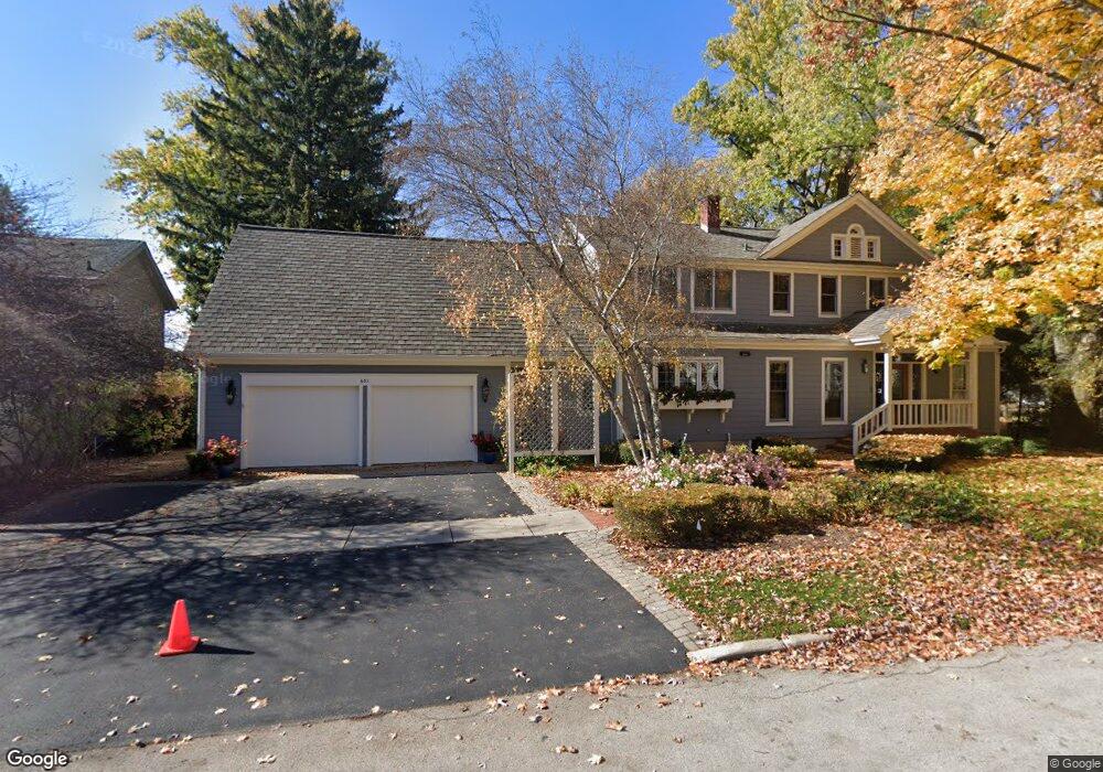
651 Leonard Pkwy Crystal Lake, IL 60014
Estimated Value: $328,000 - $1,348,000
--
Bed
1
Bath
4,328
Sq Ft
$230/Sq Ft
Est. Value
About This Home
This home is located at 651 Leonard Pkwy, Crystal Lake, IL 60014 and is currently estimated at $994,426, approximately $229 per square foot. 651 Leonard Pkwy is a home located in McHenry County with nearby schools including South Elementary School, Richard F Bernotas Middle School, and Crystal Lake Central High School.
Ownership History
Date
Name
Owned For
Owner Type
Purchase Details
Closed on
May 12, 2020
Sold by
Alt Miranda S and Hooker Christopher A
Bought by
Hooker Susan P and Hooker James H
Current Estimated Value
Purchase Details
Closed on
May 1, 2020
Sold by
Hooker Susan P and Susan P Hooker Trust
Bought by
Hooker Christopher A
Purchase Details
Closed on
Dec 30, 1999
Sold by
Hooker Susan P
Bought by
Hooker Susan P and Susan P Hooker Declaration Of Qualified
Purchase Details
Closed on
Nov 5, 1996
Sold by
Hooker James H and Hooker Susan P
Bought by
Hooker Susanp and Susan P Hooker Trust
Create a Home Valuation Report for This Property
The Home Valuation Report is an in-depth analysis detailing your home's value as well as a comparison with similar homes in the area
Home Values in the Area
Average Home Value in this Area
Purchase History
| Date | Buyer | Sale Price | Title Company |
|---|---|---|---|
| Hooker Susan P | -- | Attorney | |
| Hooker Christopher A | -- | Attorney | |
| Hooker Susan P | -- | None Available | |
| Hooker Susanp | -- | -- |
Source: Public Records
Tax History Compared to Growth
Tax History
| Year | Tax Paid | Tax Assessment Tax Assessment Total Assessment is a certain percentage of the fair market value that is determined by local assessors to be the total taxable value of land and additions on the property. | Land | Improvement |
|---|---|---|---|---|
| 2024 | $28,328 | $334,617 | $136,529 | $198,088 |
| 2023 | $27,556 | $299,273 | $122,108 | $177,165 |
| 2022 | $21,332 | $225,209 | $110,206 | $115,003 |
| 2021 | $20,263 | $209,809 | $102,670 | $107,139 |
| 2020 | $19,799 | $202,381 | $99,035 | $103,346 |
| 2019 | $19,337 | $193,703 | $94,788 | $98,915 |
| 2018 | $17,070 | $167,612 | $78,682 | $88,930 |
| 2017 | $17,045 | $157,901 | $74,123 | $83,778 |
| 2016 | $16,701 | $148,097 | $69,521 | $78,576 |
| 2013 | -- | $138,155 | $64,854 | $73,301 |
Source: Public Records
Map
Nearby Homes
- 193 Lake Ct
- 191 S Virginia St
- 130 S Virginia St
- 615 Lake Ave
- 691 Lake Ave
- 421 Lake Ave
- 277 Church St
- 348 Wiltshire Ln
- 132 S Mchenry Ave
- 221 Uteg St Unit G
- 310 2nd Ct
- 265 Sunset Dr
- 463 Hampshire Ln
- 501 Coventry Ln Unit 18
- 100 Pine Ct
- 511 Coventry Ln Unit 2
- 511 Coventry Ln Unit 3
- 337 Hickory Dr
- 600 Sussex Ln
- 704 Saint Andrews Ln
- 641 Leonard Pkwy
- 637 Leonard Pkwy
- 640 Leonard Pkwy
- 650 Leonard Pkwy
- 649 Woodland Dr
- 635 Leonard Pkwy
- 208 Lake Ct
- 651 Woodland Dr
- 198 Lake Ct
- 627 Leonard Pkwy
- 648 Leonard Pkwy
- 209 Lake Ct
- 655 Woodland Dr
- 194 Lake Ct
- 626 Leonard Pkwy
- 623 Leonard Pkwy
- 631 Woodland Dr
- 640 Woodland Dr
- 201 Lake Ct
- 624 Leonard Pkwy