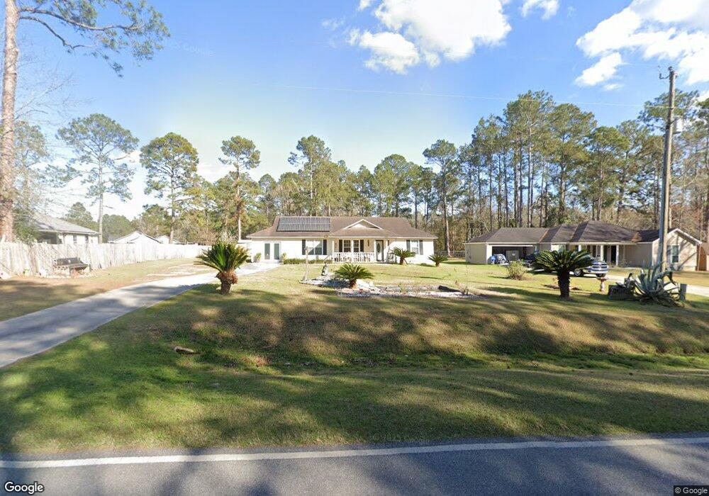
6518 Union Rd Hahira, GA 31632
Estimated Value: $207,000 - $311,000
3
Beds
2
Baths
1,242
Sq Ft
$191/Sq Ft
Est. Value
About This Home
This home is located at 6518 Union Rd, Hahira, GA 31632 and is currently estimated at $237,661, approximately $191 per square foot. 6518 Union Rd is a home located in Lowndes County with nearby schools including Hahira Elementary School, Hahira Middle School, and Lowndes High School.
Ownership History
Date
Name
Owned For
Owner Type
Purchase Details
Closed on
Sep 23, 2021
Sold by
Little Carolyn L
Bought by
Hollis Wayne Douglas
Current Estimated Value
Purchase Details
Closed on
Jul 11, 2002
Sold by
Bay Madow Corporation
Bought by
Little Carolyn L
Purchase Details
Closed on
Jul 10, 2002
Sold by
Hagan R M Trust
Bought by
Bay Madow Corporation
Purchase Details
Closed on
Oct 1, 1999
Sold by
Bay Meadow Corporation
Bought by
Hagan R M Trust
Create a Home Valuation Report for This Property
The Home Valuation Report is an in-depth analysis detailing your home's value as well as a comparison with similar homes in the area
Home Values in the Area
Average Home Value in this Area
Purchase History
| Date | Buyer | Sale Price | Title Company |
|---|---|---|---|
| Hollis Wayne Douglas | -- | -- | |
| Little Carolyn L | $12,900 | -- | |
| Bay Madow Corporation | -- | -- | |
| Hagan R M Trust | -- | -- | |
| Bay Meadow Corporation | $36,000 | -- |
Source: Public Records
Tax History Compared to Growth
Tax History
| Year | Tax Paid | Tax Assessment Tax Assessment Total Assessment is a certain percentage of the fair market value that is determined by local assessors to be the total taxable value of land and additions on the property. | Land | Improvement |
|---|---|---|---|---|
| 2024 | $1,186 | $55,715 | $16,000 | $39,715 |
| 2023 | $1,186 | $46,115 | $6,400 | $39,715 |
| 2022 | $724 | $31,975 | $6,400 | $25,575 |
| 2021 | $756 | $31,975 | $6,400 | $25,575 |
| 2020 | $746 | $33,574 | $6,400 | $27,174 |
| 2019 | $753 | $33,574 | $6,400 | $27,174 |
| 2018 | $761 | $33,574 | $6,400 | $27,174 |
| 2017 | $774 | $33,574 | $6,400 | $27,174 |
| 2016 | $776 | $33,574 | $6,400 | $27,174 |
| 2015 | $743 | $33,574 | $6,400 | $27,174 |
| 2014 | $759 | $33,574 | $6,400 | $27,174 |
Source: Public Records
Map
Nearby Homes
- 6453 Meadow Creek Rd
- 6628 Brookridge Dr
- 6622 Brookridge Dr
- 209 Orvis Ln
- The Belfort Plan at Phillips Place
- The Galen Plan at Phillips Place
- The Cali Plan at Phillips Place
- The Lakeside Plan at Phillips Place
- The Lismore Plan at Phillips Place
- 1601 Beverly Ln
- 1604 Beverly Ln
- 1596 Beverly Ln
- 840 Kristen Ln
- 819 Kristen Ln
- 489 Bryson Cir
- 303 Wright St
- 301 Wright St
- 7579 Kayla Dr
- 411 Judy Ann Dr
- 6936 Simpson Rd
- 6499 Meadow Creek Rd
- 6524 Union Rd
- 6512 Union Rd
- 6483 Meadow Creek Rd
- 6511 Brookridge Dr
- 6507 Brookridge Dr
- 6515 Brookridge Dr
- 6498 Meadow Creek Rd
- 6471 Meadow Creek Rd
- 6470 Meadow Creek Rd
- 6510 Brookridge Dr
- 6452 Meadow Creek Rd
- 6514 Brookridge Dr
- 6515 Pine Meadow Ct
- 6518 Brookridge Dr
- 6401 Hillcrest Dr
- 6446 Meadow Creek Rd
- 6522 Brookridge Dr
- 6405 Hillcrest Dr
- 6413 Hillcrest Dr