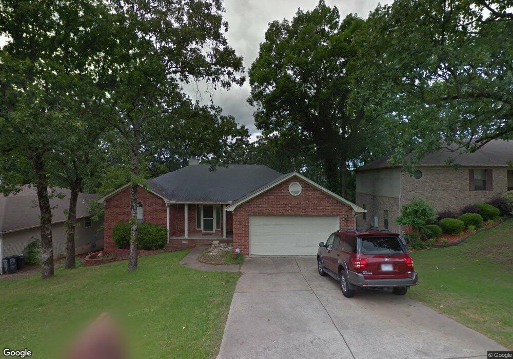
6519 Countryside Dr North Little Rock, AR 72116
Amboy NeighborhoodEstimated Value: $209,535 - $247,000
--
Bed
2
Baths
1,547
Sq Ft
$148/Sq Ft
Est. Value
About This Home
This home is located at 6519 Countryside Dr, North Little Rock, AR 72116 and is currently estimated at $228,634, approximately $147 per square foot. 6519 Countryside Dr is a home located in Pulaski County with nearby schools including Indian Hills Elementary School, North Little Rock Middle School 6th Grade Campus, and North Little Rock High School.
Ownership History
Date
Name
Owned For
Owner Type
Purchase Details
Closed on
Feb 9, 2007
Sold by
Rose Napper Rhonda L
Bought by
Franklin Donna
Current Estimated Value
Home Financials for this Owner
Home Financials are based on the most recent Mortgage that was taken out on this home.
Original Mortgage
$142,405
Outstanding Balance
$99,705
Interest Rate
9.45%
Mortgage Type
Balloon
Estimated Equity
$128,929
Purchase Details
Closed on
Jun 22, 2000
Sold by
Pinson David C
Bought by
Rose Rhonda L
Purchase Details
Closed on
Feb 26, 1999
Sold by
Conley Stephanie
Bought by
Pinson David C
Home Financials for this Owner
Home Financials are based on the most recent Mortgage that was taken out on this home.
Original Mortgage
$106,445
Interest Rate
6.8%
Mortgage Type
FHA
Create a Home Valuation Report for This Property
The Home Valuation Report is an in-depth analysis detailing your home's value as well as a comparison with similar homes in the area
Home Values in the Area
Average Home Value in this Area
Purchase History
| Date | Buyer | Sale Price | Title Company |
|---|---|---|---|
| Franklin Donna | $150,000 | American Abstract & Title Co | |
| Rose Rhonda L | $111,000 | Stewart Title | |
| Pinson David C | -- | Stewart Title | |
| Pinson David C | $109,000 | Stewart Title Of Arkansas |
Source: Public Records
Mortgage History
| Date | Status | Borrower | Loan Amount |
|---|---|---|---|
| Open | Franklin Donna | $142,405 | |
| Previous Owner | Pinson David C | $106,445 |
Source: Public Records
Tax History Compared to Growth
Tax History
| Year | Tax Paid | Tax Assessment Tax Assessment Total Assessment is a certain percentage of the fair market value that is determined by local assessors to be the total taxable value of land and additions on the property. | Land | Improvement |
|---|---|---|---|---|
| 2025 | $2,347 | $35,142 | $7,400 | $27,742 |
| 2024 | $2,286 | $35,142 | $7,400 | $27,742 |
| 2023 | $2,286 | $35,142 | $7,400 | $27,742 |
| 2022 | $2,096 | $35,142 | $7,400 | $27,742 |
| 2021 | $1,905 | $28,520 | $5,200 | $23,320 |
| 2020 | $1,905 | $28,520 | $5,200 | $23,320 |
| 2019 | $1,905 | $28,520 | $5,200 | $23,320 |
| 2018 | $1,905 | $28,520 | $5,200 | $23,320 |
| 2017 | $1,905 | $28,520 | $5,200 | $23,320 |
| 2016 | $1,927 | $28,850 | $5,200 | $23,650 |
| 2015 | $1,927 | $28,850 | $5,200 | $23,650 |
| 2014 | $1,927 | $28,850 | $5,200 | $23,650 |
Source: Public Records
Map
Nearby Homes
- 6312 Allwood Dr
- 6324 Allwood Dr
- 6317 Rolling Hills Dr
- 1115 Claycut Cir
- 6312 Rolling Hills Dr
- 813 Silver Hill Rd
- 1010 Claycut Cir
- 7 Edenwood Ln
- 5809 N Locust St
- 5709 N Cedar St
- 1209 Silverwood Trail
- 5820 Greenhurst Dr
- 59 Coronado Cir
- 5 Edenwood Ln
- 5605 N Walnut Rd
- 801 Green Hills Dr
- 126 Cobblestone Cir
- 5513 N Walnut Rd
- 5600 Belle Point Rd
- 47 Perin Rd
- 6515 Countryside Dr
- 6601 Countryside Dr
- 1116 Kierre Dr
- 6511 Countryside Dr
- 0 Countryside Dr Unit 10335283
- 0 Countryside Dr Unit 16002340
- 0 Countryside Dr Unit 16018191
- 0 Countryside Dr Unit 19014450
- 6514 Countryside Dr
- 6506 Countryside Dr
- 1112 Kierre Dr
- 6600 Countryside Dr
- 6502 Countryside Dr
- 6507 Countryside Dr
- 1205 Kierre Dr
- 1108 Kierre Dr
- 1209 Kierre Dr
- 6500 Countryside Dr
- 6503 Countryside Dr
- 1104 Kierre Dr