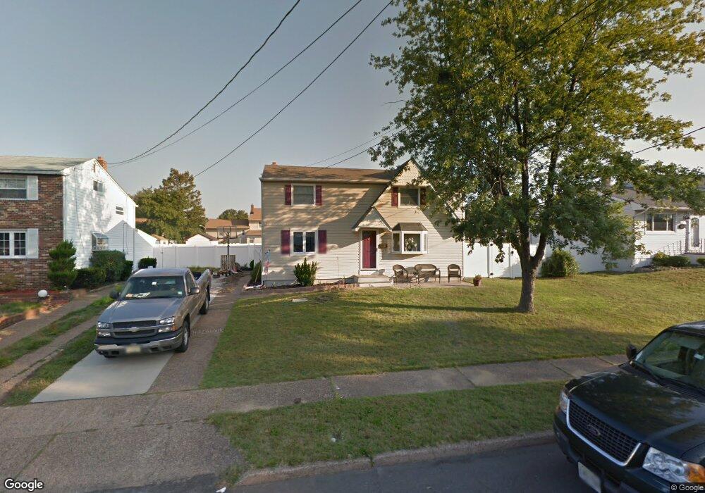
652 Andrea Rd Runnemede, NJ 08078
Estimated Value: $254,738 - $376,000
Studio
--
Bath
1,445
Sq Ft
$229/Sq Ft
Est. Value
About This Home
This home is located at 652 Andrea Rd, Runnemede, NJ 08078 and is currently estimated at $330,935, approximately $229 per square foot. 652 Andrea Rd is a home located in Camden County with nearby schools including Mary E. Volz Elementary School, Bingham Elementary School, and Triton High School.
Ownership History
Date
Name
Owned For
Owner Type
Purchase Details
Closed on
Nov 12, 2008
Sold by
Persichetti Matthew and Persichetti Denise
Bought by
Persichetti Matthew and Persichetti Denise
Current Estimated Value
Home Financials for this Owner
Home Financials are based on the most recent Mortgage that was taken out on this home.
Original Mortgage
$176,000
Interest Rate
5.31%
Mortgage Type
Purchase Money Mortgage
Purchase Details
Closed on
Jul 12, 2000
Sold by
Wharton Edward J
Bought by
Persichetti Matthew
Home Financials for this Owner
Home Financials are based on the most recent Mortgage that was taken out on this home.
Original Mortgage
$83,000
Interest Rate
8.28%
Create a Home Valuation Report for This Property
The Home Valuation Report is an in-depth analysis detailing your home's value as well as a comparison with similar homes in the area
Home Values in the Area
Average Home Value in this Area
Purchase History
| Date | Buyer | Sale Price | Title Company |
|---|---|---|---|
| Persichetti Matthew | -- | -- | |
| Persichetti Matthew | $90,000 | -- |
Source: Public Records
Mortgage History
| Date | Status | Borrower | Loan Amount |
|---|---|---|---|
| Previous Owner | Persichetti Matthew | $176,000 | |
| Previous Owner | Persichetti Matthew | $83,000 |
Source: Public Records
Tax History
| Year | Tax Paid | Tax Assessment Tax Assessment Total Assessment is a certain percentage of the fair market value that is determined by local assessors to be the total taxable value of land and additions on the property. | Land | Improvement |
|---|---|---|---|---|
| 2025 | $6,773 | $150,300 | $46,100 | $104,200 |
| 2024 | $6,567 | $150,300 | $46,100 | $104,200 |
| 2023 | $6,567 | $150,300 | $46,100 | $104,200 |
| 2022 | $6,358 | $150,300 | $46,100 | $104,200 |
| 2021 | $6,207 | $150,300 | $46,100 | $104,200 |
| 2020 | $6,146 | $150,300 | $46,100 | $104,200 |
| 2019 | $6,033 | $150,300 | $46,100 | $104,200 |
| 2018 | $5,917 | $150,300 | $46,100 | $104,200 |
| 2017 | $5,716 | $149,000 | $46,100 | $102,900 |
| 2016 | $5,644 | $149,000 | $46,100 | $102,900 |
| 2015 | $5,661 | $149,000 | $46,100 | $102,900 |
| 2014 | $5,588 | $149,000 | $46,100 | $102,900 |
Source: Public Records
Map
Nearby Homes
- 411 Center Ave
- 524 Hirsch Ave
- 167 Singley Ave
- 408 W 3rd Ave
- 850 Orchard Ave
- 206 W 5th Ave
- 311 Bowers Ave
- 60 N Oakland Ave
- 924 W Evesham Rd
- 29 W 4th Ave
- 22 W 6th Ave
- 102 W Clements Bridge Rd
- 37 S Read Ave
- 420 Zane Ave
- 425 Periwinkle Dr
- 38 Robert Dr
- 1050 Woodland Ave
- 268 Steeplechase Ct Unit 288
- 428 Arline Ave
- 263 Steeplechase Ct Unit B263
- 656 Andrea Rd
- 648 Andrea Rd
- 661 Dettmar Terrace
- 665 Dettmar Terrace
- 660 Andrea Rd
- 644 Andrea Rd
- 657 Dettmar Terrace
- 669 Dettmar Terrace
- 645 Andrea Rd
- 641 Andrea Rd
- 649 Andrea Rd
- 673 Dettmar Terrace
- 637 Andrea Rd
- 664 Andrea Rd
- 640 Andrea Rd
- 653 Andrea Rd
- 649 Dettmar Terrace
- 633 Andrea Rd
- 677 Dettmar Terrace
- 632 Burt Rd
Your Personal Tour Guide
Ask me questions while you tour the home.