Estimated Value: $687,993 - $724,000
3
Beds
3
Baths
2,114
Sq Ft
$333/Sq Ft
Est. Value
About This Home
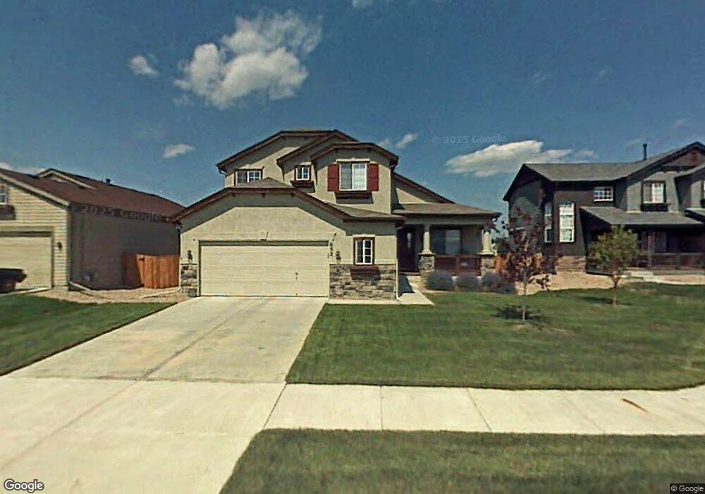
This home is located at 652 Mathews Cir, Erie, CO 80516 and is currently estimated at $704,748, approximately $333 per square foot. 652 Mathews Cir is a home located in Boulder County with nearby schools including Red Hawk Elementary School, Erie Middle School, and Erie High School.
Ownership History
Date
Name
Owned For
Owner Type
Purchase Details
Closed on
Mar 5, 2004
Sold by
Johnson Communities Inc
Bought by
Ward Dennis L
Current Estimated Value
Home Financials for this Owner
Home Financials are based on the most recent Mortgage that was taken out on this home.
Original Mortgage
$242,887
Outstanding Balance
$113,594
Interest Rate
5.68%
Mortgage Type
Unknown
Estimated Equity
$591,154
Create a Home Valuation Report for This Property
The Home Valuation Report is an in-depth analysis detailing your home's value as well as a comparison with similar homes in the area
Home Values in the Area
Average Home Value in this Area
Purchase History
| Date | Buyer | Sale Price | Title Company |
|---|---|---|---|
| Ward Dennis L | $303,609 | Land Title |
Source: Public Records
Mortgage History
| Date | Status | Borrower | Loan Amount |
|---|---|---|---|
| Open | Ward Dennis L | $242,887 | |
| Closed | Ward Dennis L | $60,595 |
Source: Public Records
Tax History Compared to Growth
Tax History
| Year | Tax Paid | Tax Assessment Tax Assessment Total Assessment is a certain percentage of the fair market value that is determined by local assessors to be the total taxable value of land and additions on the property. | Land | Improvement |
|---|---|---|---|---|
| 2025 | $4,970 | $42,713 | $10,375 | $32,338 |
| 2024 | $4,970 | $42,713 | $10,375 | $32,338 |
| 2023 | $4,915 | $43,396 | $13,889 | $33,192 |
| 2022 | $4,081 | $34,479 | $8,764 | $25,715 |
| 2021 | $4,153 | $35,471 | $9,016 | $26,455 |
| 2020 | $3,863 | $33,069 | $4,934 | $28,135 |
| 2019 | $3,853 | $33,069 | $4,934 | $28,135 |
| 2018 | $3,466 | $29,693 | $6,984 | $22,709 |
| 2017 | $3,308 | $32,827 | $7,721 | $25,106 |
| 2016 | $3,119 | $27,327 | $7,642 | $19,685 |
| 2015 | $2,993 | $22,193 | $6,448 | $15,745 |
| 2014 | $2,485 | $22,193 | $6,448 | $15,745 |
Source: Public Records
Map
Nearby Homes
- 1386 Avgare Way
- 612 Apex St
- 634 Apex St
- 1270 Hoffman Dr
- 644 N Beshear Ct
- 707 Saddle Dr
- 701 Saddle Dr
- 700 S Beshear Ct
- Newland Plan at Toll Brothers at Erie Town Center - Horizon at Erie Town Center
- Ulster Plan at Toll Brothers at Erie Town Center - Heights at Erie Town Center
- Eudora Plan at Toll Brothers at Erie Town Center - Horizon at Erie Town Center
- Glenarm Plan at Toll Brothers at Erie Town Center - Horizon at Erie Town Center
- Kearney Plan at Toll Brothers at Erie Town Center - Horizon at Erie Town Center
- Crestmoor Plan at Toll Brothers at Erie Town Center - Edge at Erie Town Center
- Tamarac Plan at Toll Brothers at Erie Town Center - Heights at Erie Town Center
- Athmar Plan at Toll Brothers at Erie Town Center - Edge at Erie Town Center
- Kennedy Plan at Toll Brothers at Erie Town Center - Edge at Erie Town Center
- Mayfair Plan at Toll Brothers at Erie Town Center - Edge at Erie Town Center
- Dailey Plan at Toll Brothers at Erie Town Center - Edge at Erie Town Center
- Roslyn Plan at Toll Brothers at Erie Town Center - Heights at Erie Town Center
- 656 Mathews Cir
- 648 Mathews Cir
- 662 Mathews Cir
- 644 Mathews Cir
- 664 Mathews Cir
- 631 Mathews Cir
- 640 Mathews Cir
- 641 Mathews Cir
- 651 Mathews Cir
- 636 Mathews Cir
- 659 Mathews Cir
- 630 Mathews Cir
- 545 Munoz Ct
- 527 Munoz Ct
- 1353 Avgare Way
- 626 Mathews Cir
- 1365 Avgare Way
- 669 Mathews Cir
- 1377 Avgare Way
- 1338 Hoffman Dr