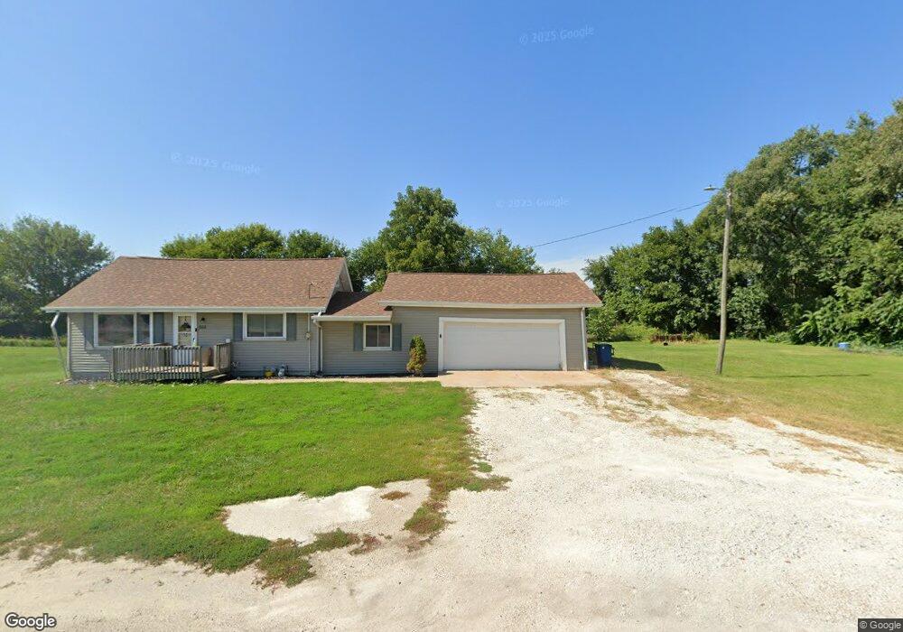
652 N Depot Rd Wataga, IL 61488
Estimated Value: $79,000 - $162,000
3
Beds
1
Bath
720
Sq Ft
$158/Sq Ft
Est. Value
About This Home
This home is located at 652 N Depot Rd, Wataga, IL 61488 and is currently estimated at $113,667, approximately $157 per square foot. 652 N Depot Rd is a home located in Knox County with nearby schools including R O W V A Jr/Sr High School.
Ownership History
Date
Name
Owned For
Owner Type
Purchase Details
Closed on
Mar 27, 2006
Sold by
Franklin Credit Mgmt Corp
Bought by
Kuelper John W and Kuelper Jessica L
Current Estimated Value
Home Financials for this Owner
Home Financials are based on the most recent Mortgage that was taken out on this home.
Original Mortgage
$40,000
Interest Rate
7.5%
Mortgage Type
New Conventional
Create a Home Valuation Report for This Property
The Home Valuation Report is an in-depth analysis detailing your home's value as well as a comparison with similar homes in the area
Home Values in the Area
Average Home Value in this Area
Purchase History
| Date | Buyer | Sale Price | Title Company |
|---|---|---|---|
| Kuelper John W | $15,000 | -- |
Source: Public Records
Mortgage History
| Date | Status | Borrower | Loan Amount |
|---|---|---|---|
| Closed | Kuelper John W | $40,000 |
Source: Public Records
Tax History Compared to Growth
Tax History
| Year | Tax Paid | Tax Assessment Tax Assessment Total Assessment is a certain percentage of the fair market value that is determined by local assessors to be the total taxable value of land and additions on the property. | Land | Improvement |
|---|---|---|---|---|
| 2024 | $1,348 | $28,180 | $5,130 | $23,050 |
| 2023 | $1,348 | $21,380 | $4,810 | $16,570 |
| 2022 | $1,497 | $18,620 | $4,190 | $14,430 |
| 2021 | $1,402 | $17,240 | $3,880 | $13,360 |
| 2020 | $1,332 | $16,120 | $3,630 | $12,490 |
| 2019 | $1,345 | $16,120 | $3,630 | $12,490 |
| 2018 | $1,345 | $16,120 | $3,630 | $12,490 |
| 2017 | $1,384 | $16,440 | $3,700 | $12,740 |
| 2015 | -- | $16,440 | $3,700 | $12,740 |
| 2013 | $1,333 | $17,300 | $3,890 | $13,410 |
Source: Public Records
Map
Nearby Homes
- 237 N Union St
- 500 E Victoria St
- 126 N Depot St
- 2260 Knox Road 600 E
- 593 Knox Road 2000 N
- 337 W Chestnut St
- 218 Mcmurtry Dr
- 207 S State St
- 530 Goodsill Dr
- 1485 Arcadia Dr
- 1347 Garden Ln
- 1223 Arcadia Dr
- 2819 Montague Dr
- 2390 U S 150
- Lot 8 Shepherd Dr
- 1508 Moshier Ave
- 499 Goodsill Dr
- Lot 9 Shepherd Dr
- 000 5th St
- Lot 7 Shepherd Dr
- 653 N Depot Rd
- 891 N Depot Rd
- 337 E Nation St
- 119 E Nation St
- 857 Knox Road 2200 N
- 432 N Simmons St
- 428 N Simmons St
- 436 N Depot Rd
- 147 E Prairie St
- 315 E Prairie St
- 139 E Prairie St
- 327 E Prairie St
- 129 E Prairie St
- 119 E Prairie St
- 841 Knox Road 2200 N
- 232 E Prairie St
- 107 E Prairie St
- 308 E Prairie St
- 320 E Prairie St
- 344 N Union St