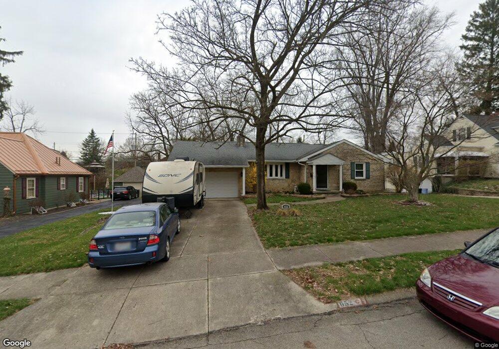
652 Riverside Dr Springfield, OH 45504
Estimated Value: $235,794 - $254,000
3
Beds
2
Baths
1,548
Sq Ft
$157/Sq Ft
Est. Value
About This Home
This home is located at 652 Riverside Dr, Springfield, OH 45504 and is currently estimated at $243,449, approximately $157 per square foot. 652 Riverside Dr is a home located in Clark County with nearby schools including Snowhill Elementary School, Roosevelt Middle School, and Springfield High School.
Ownership History
Date
Name
Owned For
Owner Type
Purchase Details
Closed on
Dec 22, 2005
Sold by
Bremer Joe Seth and Bremer Celestial Ann
Bought by
Lemon Jack M and Lemon Ruth D
Current Estimated Value
Home Financials for this Owner
Home Financials are based on the most recent Mortgage that was taken out on this home.
Original Mortgage
$136,000
Interest Rate
6.4%
Mortgage Type
VA
Create a Home Valuation Report for This Property
The Home Valuation Report is an in-depth analysis detailing your home's value as well as a comparison with similar homes in the area
Home Values in the Area
Average Home Value in this Area
Purchase History
| Date | Buyer | Sale Price | Title Company |
|---|---|---|---|
| Lemon Jack M | $136,000 | None Available |
Source: Public Records
Mortgage History
| Date | Status | Borrower | Loan Amount |
|---|---|---|---|
| Closed | Lemon Jack M | $136,000 |
Source: Public Records
Tax History Compared to Growth
Tax History
| Year | Tax Paid | Tax Assessment Tax Assessment Total Assessment is a certain percentage of the fair market value that is determined by local assessors to be the total taxable value of land and additions on the property. | Land | Improvement |
|---|---|---|---|---|
| 2024 | $2,462 | $60,250 | $8,190 | $52,060 |
| 2023 | $2,462 | $60,250 | $8,190 | $52,060 |
| 2022 | $2,542 | $60,250 | $8,190 | $52,060 |
| 2021 | $1,854 | $43,430 | $6,300 | $37,130 |
| 2020 | $1,858 | $43,430 | $6,300 | $37,130 |
| 2019 | $1,863 | $43,430 | $6,300 | $37,130 |
| 2018 | $1,937 | $43,390 | $5,480 | $37,910 |
| 2017 | $1,936 | $43,845 | $5,478 | $38,367 |
| 2016 | $1,938 | $43,845 | $5,478 | $38,367 |
| 2015 | $1,875 | $43,845 | $5,478 | $38,367 |
| 2014 | $1,867 | $43,845 | $5,478 | $38,367 |
| 2013 | $1,847 | $43,845 | $5,478 | $38,367 |
Source: Public Records
Map
Nearby Homes
- 648 Riverside Dr
- 640 Riverside Dr
- 641 W Harding Rd
- 707 W Harding Rd
- 720 Riverside Dr
- 636 Riverside Dr
- 1645 Woodrow Dr
- 625 W Harding Rd
- 721 W Harding Rd
- 630 Riverside Dr
- 723 W Harding Rd
- 648 W Harding Rd
- 601 W Harding Rd
- 1625 Woodrow Dr
- 730 Riverside Dr
- 640 W Harding Rd
- 731 W Harding Rd
- 1652 Woodrow Dr
- 710 W Harding Rd
- 0 Saint Paris Pike