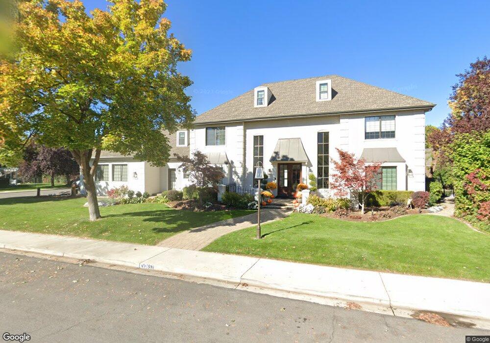
652 S 1050 E Orem, UT 84097
SCERA NeighborhoodEstimated Value: $2,057,773 - $3,069,000
7
Beds
6
Baths
8,119
Sq Ft
$316/Sq Ft
Est. Value
About This Home
This home is located at 652 S 1050 E, Orem, UT 84097 and is currently estimated at $2,563,387, approximately $315 per square foot. 652 S 1050 E is a home located in Utah County with nearby schools including Centennial Elementary, Lakeridge Jr High School, and Orem High School.
Ownership History
Date
Name
Owned For
Owner Type
Purchase Details
Closed on
Jul 13, 2021
Sold by
Holman Kimburly and Holman Nancy
Bought by
Holman Nancy and The Blw Trust
Current Estimated Value
Purchase Details
Closed on
Nov 20, 2020
Sold by
Phillips James Kerwin and Phillips Starla Rae
Bought by
Holman Kimburly and Holman Nancy
Home Financials for this Owner
Home Financials are based on the most recent Mortgage that was taken out on this home.
Original Mortgage
$700,000
Outstanding Balance
$622,901
Interest Rate
2.8%
Mortgage Type
New Conventional
Estimated Equity
$1,940,486
Purchase Details
Closed on
Nov 21, 1997
Sold by
Phillips James and Phillips Starla
Bought by
Phillips James Kerwin and Phillips Starla Rae
Home Financials for this Owner
Home Financials are based on the most recent Mortgage that was taken out on this home.
Original Mortgage
$505,000
Interest Rate
7.33%
Create a Home Valuation Report for This Property
The Home Valuation Report is an in-depth analysis detailing your home's value as well as a comparison with similar homes in the area
Home Values in the Area
Average Home Value in this Area
Purchase History
| Date | Buyer | Sale Price | Title Company |
|---|---|---|---|
| Holman Nancy | -- | None Available | |
| Holman Kimburly | -- | Backman Orem | |
| Phillips James Kerwin | -- | Backman Orem | |
| Phillips James Kerwin | -- | -- | |
| Phillips James | -- | -- |
Source: Public Records
Mortgage History
| Date | Status | Borrower | Loan Amount |
|---|---|---|---|
| Open | Holman Kimburly | $700,000 | |
| Previous Owner | Phillips James | $505,000 |
Source: Public Records
Tax History
| Year | Tax Paid | Tax Assessment Tax Assessment Total Assessment is a certain percentage of the fair market value that is determined by local assessors to be the total taxable value of land and additions on the property. | Land | Improvement |
|---|---|---|---|---|
| 2025 | $6,867 | $988,020 | -- | -- |
| 2024 | $6,867 | $839,685 | $0 | $0 |
| 2023 | $6,124 | $804,870 | $0 | $0 |
| 2022 | $5,794 | $737,715 | $0 | $0 |
| 2021 | $5,362 | $1,034,100 | $274,000 | $760,100 |
| 2020 | $4,533 | $859,200 | $219,200 | $640,000 |
| 2019 | $3,989 | $786,300 | $219,200 | $567,100 |
| 2018 | $4,105 | $773,100 | $206,000 | $567,100 |
| 2017 | $3,847 | $388,080 | $0 | $0 |
| 2016 | $3,729 | $347,380 | $0 | $0 |
| 2015 | -- | $313,060 | $0 | $0 |
| 2014 | $3,234 | $283,250 | $0 | $0 |
Source: Public Records
Map
Nearby Homes
- 652 S River Breeze Dr
- 1031 E Riverhaven Cir
- 31 E River Haven Cir
- 1025 E Riverhaven Cir
- 1025 E 660 S
- 680 S River Breeze Dr
- 639 S River Breeze Dr
- 675 S River Breeze Dr
- 657 S River Breeze Dr
- 1024 E River Haven Cir
- 1024 E Riverhaven Cir
- 1024 E Riverhaven Cir
- 616 S River Breeze Dr
- 621 S River Breeze Dr
- 1012 E Riverhaven Cir
- 689 S River Breeze Dr
- 1025 E 690 S
- 689 S 1050 E
- 1000 E Riverhaven Cir
- 1000 E River Haven Cir
Your Personal Tour Guide
Ask me questions while you tour the home.