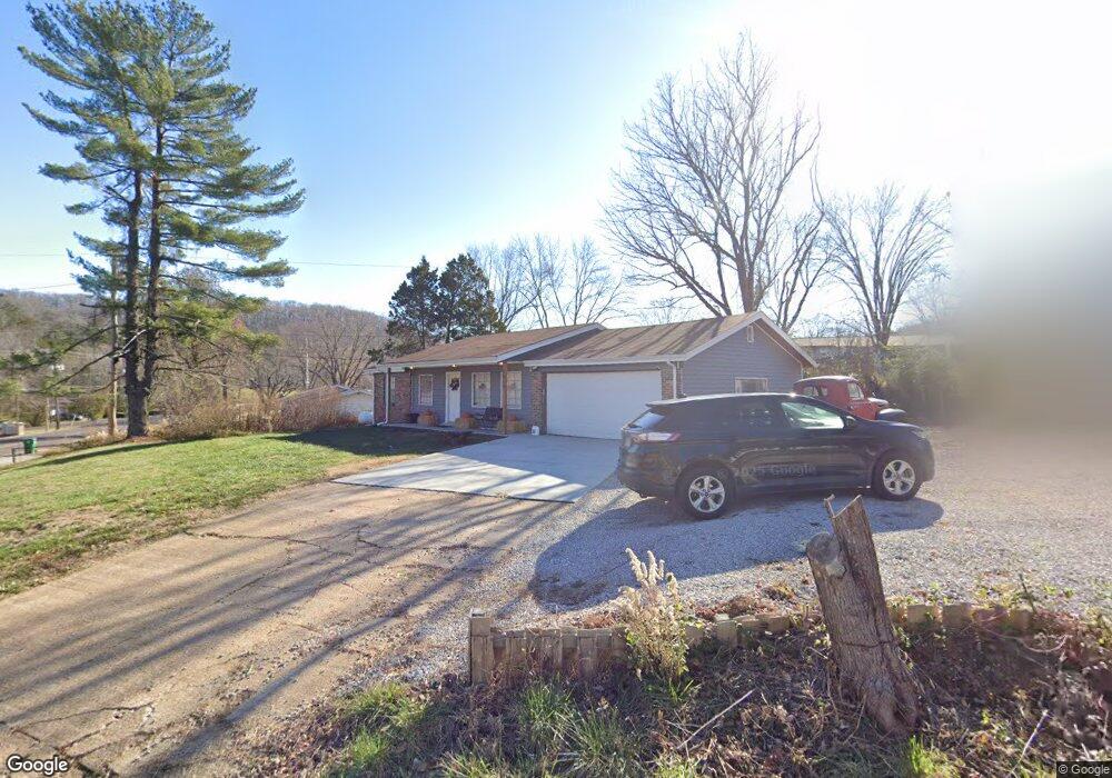
6520 Highway Pp High Ridge, MO 63049
Estimated Value: $184,000 - $215,000
Studio
1
Bath
1,040
Sq Ft
$194/Sq Ft
Est. Value
About This Home
This home is located at 6520 Highway Pp, High Ridge, MO 63049 and is currently estimated at $201,576, approximately $193 per square foot. 6520 Highway Pp is a home located in Jefferson County with nearby schools including Northwest High School and St. Anthony School.
Ownership History
Date
Name
Owned For
Owner Type
Purchase Details
Closed on
May 14, 2021
Sold by
Eaton Amanda
Bought by
Eaton Amanda and White Brandon
Current Estimated Value
Home Financials for this Owner
Home Financials are based on the most recent Mortgage that was taken out on this home.
Original Mortgage
$128,571
Outstanding Balance
$115,327
Interest Rate
3%
Mortgage Type
FHA
Estimated Equity
$86,249
Purchase Details
Closed on
Nov 24, 2020
Sold by
Price Real Estate Inv Inc
Bought by
Mallonga Edcyril Ernest
Home Financials for this Owner
Home Financials are based on the most recent Mortgage that was taken out on this home.
Original Mortgage
$102,000
Interest Rate
2.8%
Mortgage Type
New Conventional
Purchase Details
Closed on
Jan 27, 2014
Sold by
The Secretary Of Hud
Bought by
Sparks Kenneth L
Purchase Details
Closed on
Jul 22, 2013
Sold by
Ocwen Loan Servicing Llc
Bought by
Secretary Of Hud
Purchase Details
Closed on
Jun 28, 2013
Sold by
Hays Marlana Kaye and Hays Matthew J
Bought by
Ocwen Loan Servicing Llc
Purchase Details
Closed on
May 22, 2009
Sold by
Hays Mariana Kaye and Hays Matthew J
Bought by
Hays Mariana Kaye and Hays Matthew J
Home Financials for this Owner
Home Financials are based on the most recent Mortgage that was taken out on this home.
Original Mortgage
$144,579
Interest Rate
4.72%
Mortgage Type
FHA
Purchase Details
Closed on
Jun 27, 2007
Sold by
Colbert Marlana Kaye and Colbert Marlana K
Bought by
Colbert Marlana Kaye and Hays Matthew J
Home Financials for this Owner
Home Financials are based on the most recent Mortgage that was taken out on this home.
Original Mortgage
$142,709
Interest Rate
6.37%
Mortgage Type
New Conventional
Purchase Details
Closed on
Dec 30, 2005
Sold by
Howery William T and Howery Fumiko N
Bought by
Colbert Marlana Kaye and Colbert Marlana K
Create a Home Valuation Report for This Property
The Home Valuation Report is an in-depth analysis detailing your home's value as well as a comparison with similar homes in the area
Home Values in the Area
Average Home Value in this Area
Purchase History
| Date | Buyer | Sale Price | Title Company |
|---|---|---|---|
| Eaton Amanda | -- | None Available | |
| Eaton Amanda | -- | None Available | |
| Mallonga Edcyril Ernest | -- | Continental Title | |
| Price Real Estate Investments Inc | -- | Continental Title Co | |
| Sparks Kenneth L | -- | None Available | |
| Secretary Of Hud | -- | None Available | |
| Ocwen Loan Servicing Llc | $38,000 | None Available | |
| Hays Mariana Kaye | -- | Investors Title Co | |
| Colbert Marlana Kaye | -- | Htc | |
| Colbert Marlana Kaye | -- | None Available |
Source: Public Records
Mortgage History
| Date | Status | Borrower | Loan Amount |
|---|---|---|---|
| Open | Eaton Amanda | $128,571 | |
| Previous Owner | Mallonga Edcyril Ernest | $102,000 | |
| Previous Owner | Hays Mariana Kaye | $144,579 | |
| Previous Owner | Colbert Marlana Kaye | $142,709 |
Source: Public Records
Tax History
| Year | Tax Paid | Tax Assessment Tax Assessment Total Assessment is a certain percentage of the fair market value that is determined by local assessors to be the total taxable value of land and additions on the property. | Land | Improvement |
|---|---|---|---|---|
| 2025 | $1,141 | $17,100 | $1,900 | $15,200 |
| 2024 | $1,141 | $15,800 | $1,900 | $13,900 |
| 2023 | $1,141 | $15,800 | $1,900 | $13,900 |
| 2022 | $1,136 | $15,800 | $1,900 | $13,900 |
| 2021 | $1,129 | $15,800 | $1,900 | $13,900 |
| 2020 | $1,039 | $14,200 | $1,600 | $12,600 |
| 2019 | $1,038 | $14,200 | $1,600 | $12,600 |
| 2018 | $1,052 | $14,200 | $1,600 | $12,600 |
| 2017 | $961 | $14,200 | $1,600 | $12,600 |
| 2016 | $881 | $12,900 | $1,700 | $11,200 |
| 2015 | $905 | $12,900 | $1,700 | $11,200 |
| 2013 | -- | $12,600 | $1,700 | $10,900 |
Source: Public Records
Map
Nearby Homes
- 6428 Kathy Dr
- 6752 Walnut Valley Dr
- 45 Rd
- 3208 Echo Lake Dr
- 3 & 5 Broken Arrow Ct
- 32.5 Ac Twin River Rd
- 7000 Twin River Rd
- 220 Echo Lake Cir
- 7029 Twin River Rd
- 6252 N Lakeshore Dr
- 3628 Wheatfield Cir
- 5800 5800 St Rd Pp
- 6713 Silverstone Ct
- 0 Old Gravois Rd
- 2714 Royal Oak Dr
- 2408 Williams Creek Rd
- 146 Silverstone Cir
- 6302 Upper Byrnes Mill Rd
- 302 Anthony Cir
- 5625 Circle Dr
- 6520 Missouri Pp
- 3004 W Rainbow Dr
- 6516 Highway Pp
- 6516 State Road Pp
- 3001 W Rainbow Dr
- 3013 E Rainbow Dr
- 3008 W Rainbow Dr
- 2929 Paula Ln
- 3005 W Rainbow Dr
- 3017 E Rainbow Dr
- 2933 Paula Ln
- 2925 Paula Ln
- 6512 Highway Pp
- 6529 Highway Pp
- 6529 State Road Pp
- 3012 W Rainbow Dr
- 3012 E Rainbow Dr
- 6533 Missouri Pp
- 3016 E Rainbow Dr
- 6461 Sunset Dr
Your Personal Tour Guide
Ask me questions while you tour the home.