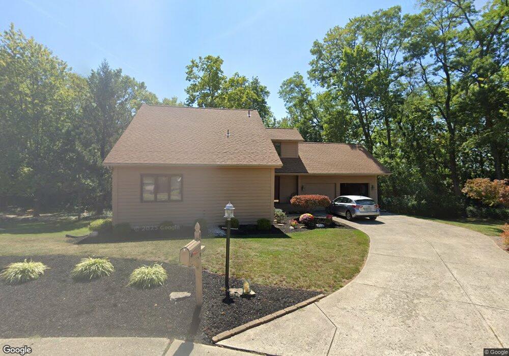
6520 Shadow Wynd Cir Dayton, OH 45459
Woodbourne-Hyde Park NeighborhoodEstimated Value: $352,000 - $383,000
3
Beds
3
Baths
2,094
Sq Ft
$173/Sq Ft
Est. Value
About This Home
This home is located at 6520 Shadow Wynd Cir, Dayton, OH 45459 and is currently estimated at $362,931, approximately $173 per square foot. 6520 Shadow Wynd Cir is a home located in Montgomery County with nearby schools including Primary Village North, Driscoll Elementary School, and Tower Heights Middle School.
Ownership History
Date
Name
Owned For
Owner Type
Purchase Details
Closed on
Dec 22, 1997
Sold by
Union Planters National Bank
Bought by
Owsley Steven D and Owsley Christine M
Current Estimated Value
Purchase Details
Closed on
Dec 19, 1997
Sold by
Weissman Robert and Weissman Judith M
Bought by
Owsley Steven D and Owsley Christine M
Create a Home Valuation Report for This Property
The Home Valuation Report is an in-depth analysis detailing your home's value as well as a comparison with similar homes in the area
Home Values in the Area
Average Home Value in this Area
Purchase History
| Date | Buyer | Sale Price | Title Company |
|---|---|---|---|
| Owsley Steven D | -- | -- | |
| Owsley Steven D | -- | -- | |
| Owsley Steven D | $168,500 | -- |
Source: Public Records
Tax History Compared to Growth
Tax History
| Year | Tax Paid | Tax Assessment Tax Assessment Total Assessment is a certain percentage of the fair market value that is determined by local assessors to be the total taxable value of land and additions on the property. | Land | Improvement |
|---|---|---|---|---|
| 2024 | $5,285 | $91,010 | $21,660 | $69,350 |
| 2023 | $5,285 | $91,010 | $21,660 | $69,350 |
| 2022 | $5,331 | $72,810 | $17,330 | $55,480 |
| 2021 | $5,345 | $72,810 | $17,330 | $55,480 |
| 2020 | $5,338 | $72,810 | $17,330 | $55,480 |
| 2019 | $5,429 | $66,100 | $17,330 | $48,770 |
| 2018 | $4,812 | $66,100 | $17,330 | $48,770 |
| 2017 | $4,756 | $66,100 | $17,330 | $48,770 |
| 2016 | $4,788 | $62,800 | $17,330 | $45,470 |
| 2015 | $4,738 | $62,800 | $17,330 | $45,470 |
| 2014 | $4,738 | $62,800 | $17,330 | $45,470 |
| 2012 | -- | $68,850 | $19,250 | $49,600 |
Source: Public Records
Map
Nearby Homes
- 1165 Kitts Hill Rd
- 870 E Whipp Rd
- 281 N Village Dr
- 1060 Heathshire Dr
- 1237 Chevington Ct Unit 1515
- 1311 Hollow Run Unit 11
- 1311 Hollow Run Unit 6
- 121 S Village Dr
- 7111 Fallen Oak Trace Unit 1050
- 1310 Hollow Run Unit 3
- 1316 Daventry Ct Unit 25D3131
- 7128 Hartcrest Ln Unit 130130
- 7128 Hartcrest Ln Unit 130
- 7129 Fallen Oak Trace Unit 839
- 6610 Green Branch Dr
- 6102 Singletree Ln
- 1457 Carriage Trace Blvd Unit 4
- 6067 Hackamore Trail Unit 20
- 6063 Hackamore Trail Unit 18
- 1511 Lake Pointe Way
- 6521 Shadow Wynd Cir
- 6510 Shadow Wynd Cir
- 6511 Shadow Wynd Cir
- 790 Kentshire Dr
- 6501 Shadow Wynd Cir
- 800 Kentshire Dr
- 791 Kentshire Dr
- 770 Kentshire Dr
- 6434 Marshall Rd
- 810 Kentshire Dr
- 6432 Marshall Rd
- 801 Kentshire Dr
- 760 Kentshire Dr
- 820 Kentshire Dr
- 759 Kentshire Dr
- 6411 Hidden Hills Dr
- 6435 Marshall Rd
- 830 Kentshire Dr
- 6430 Marshall Rd
- 6420 Hidden Hills Dr