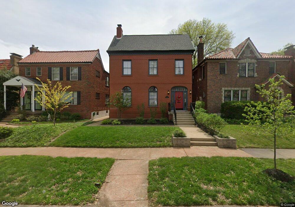
6522 Devonshire Ave Saint Louis, MO 63109
Saint Louis Hills NeighborhoodEstimated Value: $502,000 - $704,000
4
Beds
4
Baths
2,466
Sq Ft
$246/Sq Ft
Est. Value
About This Home
This home is located at 6522 Devonshire Ave, Saint Louis, MO 63109 and is currently estimated at $606,591, approximately $245 per square foot. 6522 Devonshire Ave is a home located in St. Louis City with nearby schools including Buder Elementary School, Long International Middle School, and Roosevelt High School.
Ownership History
Date
Name
Owned For
Owner Type
Purchase Details
Closed on
May 25, 2012
Sold by
Martin Loni N and Martin Michael Stephens
Bought by
Betz Robert M and Betz Jennifer K
Current Estimated Value
Home Financials for this Owner
Home Financials are based on the most recent Mortgage that was taken out on this home.
Original Mortgage
$336,000
Outstanding Balance
$233,125
Interest Rate
3.93%
Mortgage Type
New Conventional
Estimated Equity
$373,466
Purchase Details
Closed on
Sep 23, 1997
Sold by
Martin Loni N
Bought by
Martin Loni N and Martin Michael Stephens
Purchase Details
Closed on
Sep 22, 1997
Sold by
Martin M Stephens and Martin Michael Stephens
Bought by
Martin Loni N
Create a Home Valuation Report for This Property
The Home Valuation Report is an in-depth analysis detailing your home's value as well as a comparison with similar homes in the area
Home Values in the Area
Average Home Value in this Area
Purchase History
| Date | Buyer | Sale Price | Title Company |
|---|---|---|---|
| Betz Robert M | -- | Integrity Land Title Co Inc | |
| Martin Loni N | -- | -- | |
| Martin Loni N | -- | -- |
Source: Public Records
Mortgage History
| Date | Status | Borrower | Loan Amount |
|---|---|---|---|
| Open | Betz Robert M | $336,000 |
Source: Public Records
Tax History
| Year | Tax Paid | Tax Assessment Tax Assessment Total Assessment is a certain percentage of the fair market value that is determined by local assessors to be the total taxable value of land and additions on the property. | Land | Improvement |
|---|---|---|---|---|
| 2025 | $8,412 | $109,980 | $5,660 | $104,320 |
| 2024 | $8,012 | $97,170 | $5,660 | $91,510 |
| 2023 | $8,012 | $97,170 | $5,660 | $91,510 |
| 2022 | $7,632 | $91,990 | $5,660 | $86,330 |
| 2021 | $7,621 | $91,990 | $5,660 | $86,330 |
| 2020 | $6,749 | $82,060 | $5,660 | $76,400 |
| 2019 | $6,726 | $82,060 | $5,660 | $76,400 |
| 2018 | $6,640 | $78,530 | $5,320 | $73,210 |
| 2017 | $6,527 | $78,530 | $5,320 | $73,210 |
| 2016 | $6,266 | $74,420 | $5,320 | $69,100 |
| 2015 | $5,676 | $74,420 | $5,320 | $69,100 |
| 2014 | $5,988 | $87,720 | $5,320 | $82,400 |
| 2013 | -- | $78,570 | $5,320 | $73,250 |
Source: Public Records
Map
Nearby Homes
- 6637 Devonshire Ave Unit 2
- 6663 Devonshire Ave
- 6709 Lansdowne Ave
- 6409 Sutherland Ave
- 6732 Sutherland Ave
- 6714 Bancroft Ave
- 4719 Jamieson Ave Unit 4
- 4313 Jamieson Ave
- 3915 Prather Ave
- 3947 Jamieson Ave
- 3903 Prather Ave
- 6927-6931 Sutherland Ave
- 6957 Chippewa St
- 6758 Neosho St
- 6962 Sutherland Ave
- 3905 Tamm Ave
- 6968 Lansdowne Ave
- 6031 Lansdowne Ave
- 6439 Mardel Ave
- 6973 Winona Ave
- 6526 Devonshire Ave
- 6518 Devonshire Ave
- 6514 Devonshire Ave
- 6530 Devonshire Ave
- 6510 Devonshire Ave
- 6512 Devonshire Ave
- 6523 Murdoch Ave
- 6536 Devonshire Ave
- 6519 Murdoch Ave
- 6527 Murdoch Ave
- 6531 Murdoch Ave
- 6515 Murdoch Ave
- 6504 Devonshire Ave
- 6511 Murdoch Ave
- 6521 Devonshire Ave
- 6525 Devonshire Ave
- 6519 Devonshire Ave
- 6507 Murdoch Ave
- 6527 Devonshire Ave
- 6527 Devonshire Ave Unit A
Your Personal Tour Guide
Ask me questions while you tour the home.