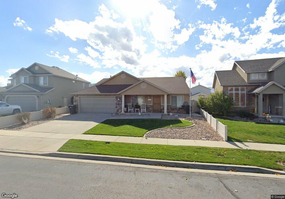
653 W 170 N Spanish Fork, UT 84660
Estimated Value: $468,000 - $541,000
3
Beds
2
Baths
1,793
Sq Ft
$276/Sq Ft
Est. Value
About This Home
This home is located at 653 W 170 N, Spanish Fork, UT 84660 and is currently estimated at $494,128, approximately $275 per square foot. 653 W 170 N is a home located in Utah County with nearby schools including Brockbank Elementary School, Spanish Fork Jr High School, and Spanish Fork High School.
Ownership History
Date
Name
Owned For
Owner Type
Purchase Details
Closed on
Aug 13, 2024
Sold by
Msm Rentals Llc
Bought by
Breese Sidney Alan and Livin Gail
Current Estimated Value
Purchase Details
Closed on
May 6, 2024
Sold by
Schardine Kimberly and Marlene N Harkness Trust
Bought by
Msm Rentals Llc
Purchase Details
Closed on
Sep 26, 2008
Sold by
Llewellyn Marlene N
Bought by
Harkness Marlene N
Purchase Details
Closed on
Sep 12, 2003
Sold by
Mtm Ltd
Bought by
Salisbury Development Lc
Create a Home Valuation Report for This Property
The Home Valuation Report is an in-depth analysis detailing your home's value as well as a comparison with similar homes in the area
Home Values in the Area
Average Home Value in this Area
Purchase History
| Date | Buyer | Sale Price | Title Company |
|---|---|---|---|
| Breese Sidney Alan | -- | Access Title | |
| Msm Rentals Llc | -- | Access Title | |
| Harkness Marlene N | -- | None Available | |
| Salisbury Development Lc | -- | Title West Title Company |
Source: Public Records
Tax History Compared to Growth
Tax History
| Year | Tax Paid | Tax Assessment Tax Assessment Total Assessment is a certain percentage of the fair market value that is determined by local assessors to be the total taxable value of land and additions on the property. | Land | Improvement |
|---|---|---|---|---|
| 2025 | $2,231 | $249,810 | $193,000 | $261,200 |
| 2024 | $2,231 | $229,955 | $0 | $0 |
| 2023 | $2,258 | $233,035 | $0 | $0 |
| 2022 | $2,205 | $223,190 | $0 | $0 |
| 2021 | $1,840 | $297,900 | $115,300 | $182,600 |
| 2020 | $1,711 | $269,300 | $104,800 | $164,500 |
| 2019 | $1,580 | $261,700 | $98,400 | $163,300 |
| 2018 | $1,422 | $227,700 | $85,700 | $142,000 |
| 2017 | $1,395 | $120,010 | $0 | $0 |
| 2016 | $1,401 | $118,965 | $0 | $0 |
| 2015 | -- | $118,965 | $0 | $0 |
| 2014 | $1,351 | $113,740 | $0 | $0 |
Source: Public Records
Map
Nearby Homes
- 1788 N 630 St W Unit 47
- 1826 N 630 St W Unit 101
- 1841 N 630 St W Unit 71
- 13 N 710 W
- 833 W 250 N
- 226 N 860 W Unit 156
- 1040 W Center St
- 956 W 40 N
- 88 S 400 W
- 393 N 400 W
- 294 W 200 N
- 134 N 300 W
- 559 N Mitchell Dr
- 231 S 880 W
- 2645 W 360 S Unit 1
- 2576 W 360 S Unit 5
- 433 N 100 W
- 225 W 300 S
- 1026 W 350 S
- 40 W 400 N Unit 1-6