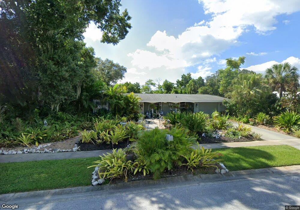
6532 Seagate Ave Sarasota, FL 34231
Estimated Value: $368,000 - $457,000
2
Beds
2
Baths
1,640
Sq Ft
$263/Sq Ft
Est. Value
About This Home
This home is located at 6532 Seagate Ave, Sarasota, FL 34231 and is currently estimated at $431,696, approximately $263 per square foot. 6532 Seagate Ave is a home located in Sarasota County with nearby schools including Gulf Gate Elementary School, Riverview High School, and Brookside Middle School.
Ownership History
Date
Name
Owned For
Owner Type
Purchase Details
Closed on
Feb 28, 2000
Sold by
Stirling Robert L and Stirling Edna
Bought by
Dareing Richard G and Brewer William P
Current Estimated Value
Home Financials for this Owner
Home Financials are based on the most recent Mortgage that was taken out on this home.
Original Mortgage
$88,000
Outstanding Balance
$28,276
Interest Rate
8.21%
Estimated Equity
$403,420
Create a Home Valuation Report for This Property
The Home Valuation Report is an in-depth analysis detailing your home's value as well as a comparison with similar homes in the area
Home Values in the Area
Average Home Value in this Area
Purchase History
| Date | Buyer | Sale Price | Title Company |
|---|---|---|---|
| Dareing Richard G | $110,000 | -- | |
| Dareing Richard G | $110,000 | -- |
Source: Public Records
Mortgage History
| Date | Status | Borrower | Loan Amount |
|---|---|---|---|
| Open | Dareing Richard G | $88,000 | |
| Closed | Dareing Richard G | $88,000 |
Source: Public Records
Tax History
| Year | Tax Paid | Tax Assessment Tax Assessment Total Assessment is a certain percentage of the fair market value that is determined by local assessors to be the total taxable value of land and additions on the property. | Land | Improvement |
|---|---|---|---|---|
| 2025 | $1,957 | $156,847 | -- | -- |
| 2024 | $1,850 | $152,427 | -- | -- |
| 2023 | $1,850 | $147,987 | $0 | $0 |
| 2022 | $1,790 | $143,677 | $0 | $0 |
| 2021 | $1,745 | $139,492 | $0 | $0 |
| 2020 | $1,733 | $137,566 | $0 | $0 |
| 2019 | $1,656 | $134,473 | $0 | $0 |
| 2018 | $1,602 | $131,966 | $0 | $0 |
| 2017 | $1,593 | $129,252 | $0 | $0 |
| 2016 | $1,581 | $169,700 | $73,500 | $96,200 |
| 2015 | $1,605 | $166,200 | $70,000 | $96,200 |
| 2014 | $1,596 | $122,873 | $0 | $0 |
Source: Public Records
Map
Nearby Homes
- 6226 Camphor Ave
- 6906 Woodwind Dr Unit 12
- 6726 S Lockwood Ridge Rd
- 6711 S Lockwood Ridge Rd
- 2066 Sun Home St Unit Lot C10
- 2833 Valley Forge St
- 6215 Rodgers Ave
- 2094 Detroiter St
- 2081 Detroiter St
- 2918 Williamsburg St
- 2050 Champion St
- 2121 Pueblo Cir Unit V6
- 2153 Pueblo Cir Unit 14
- 2043 Sun Home St
- 7151 Wood Creek Dr Unit 205
- 7143 Wood Creek Dr Unit 203
- 2036 S Mobile Estates Dr
- 2037 Champion St
- 6010 Nutmeg Ave
- 7205 Wood Creek Dr Unit 16
- 6528 Seagate Ave
- 2619 Clipper Ship Way
- 2613 Clipper Ship Way
- 2625 Clipper Ship Way
- 6535 Seagate Ave
- 6543 Seagate Ave
- 6524 Seagate Ave
- 6549 Seagate Ave
- 6523 Seagate Ave
- 2607 Clipper Ship Way
- 6607 Seagate Ave
- 6610 Seagate Ave
- 2556 Clipper Ship Way
- 6520 Seagate Ave
- 2634 Clipper Ship Way
- 2616 Clipper Ship Way
- 6614 Anchor Way
- 2738 White Sands Dr
- 6602 Anchor Way Unit 6
- 6519 Seagate Ave
Your Personal Tour Guide
Ask me questions while you tour the home.