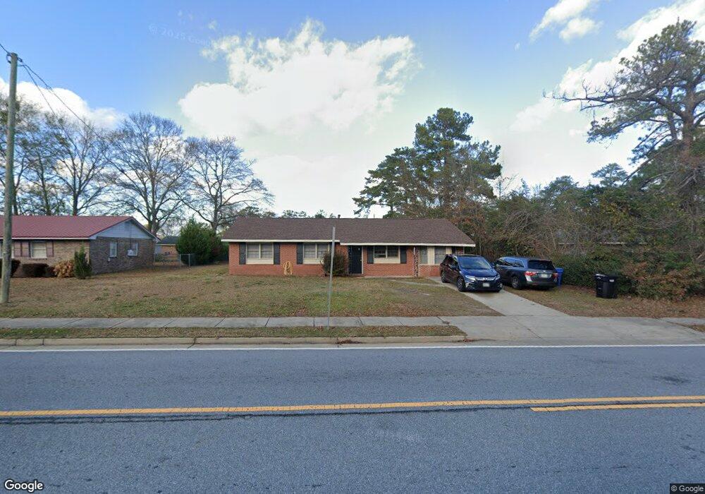
6539 Forrest Rd Columbus, GA 31907
East Columbus NeighborhoodEstimated Value: $128,193 - $157,000
3
Beds
2
Baths
1,271
Sq Ft
$115/Sq Ft
Est. Value
About This Home
This home is located at 6539 Forrest Rd, Columbus, GA 31907 and is currently estimated at $145,798, approximately $114 per square foot. 6539 Forrest Rd is a home located in Muscogee County with nearby schools including Forrest Road Elementary School, Fort Middle School, and Kendrick High School.
Ownership History
Date
Name
Owned For
Owner Type
Purchase Details
Closed on
Oct 25, 2019
Sold by
Wells Fargo Bank Na
Bought by
Syed Family Trust
Current Estimated Value
Purchase Details
Closed on
May 7, 2019
Sold by
Layfield Doris
Bought by
Wells Fargo Bank Na Trustee and Carrington Mtg Loan Trust
Create a Home Valuation Report for This Property
The Home Valuation Report is an in-depth analysis detailing your home's value as well as a comparison with similar homes in the area
Home Values in the Area
Average Home Value in this Area
Purchase History
| Date | Buyer | Sale Price | Title Company |
|---|---|---|---|
| Syed Family Trust | $30,750 | -- | |
| Wells Fargo Bank Na Trustee | $42,700 | -- |
Source: Public Records
Tax History
| Year | Tax Paid | Tax Assessment Tax Assessment Total Assessment is a certain percentage of the fair market value that is determined by local assessors to be the total taxable value of land and additions on the property. | Land | Improvement |
|---|---|---|---|---|
| 2025 | $1,613 | $41,212 | $8,848 | $32,364 |
| 2024 | $1,613 | $41,212 | $8,848 | $32,364 |
| 2023 | $1,623 | $41,212 | $8,848 | $32,364 |
| 2022 | $1,247 | $30,544 | $8,848 | $21,696 |
| 2021 | $1,003 | $24,516 | $8,848 | $15,668 |
| 2020 | $502 | $12,280 | $5,000 | $7,280 |
| 2019 | $874 | $24,240 | $8,848 | $15,392 |
| 2018 | $874 | $24,240 | $8,848 | $15,392 |
| 2017 | $994 | $24,240 | $8,848 | $15,392 |
| 2016 | $883 | $34,686 | $2,240 | $32,446 |
| 2015 | $354 | $34,686 | $2,240 | $32,446 |
| 2014 | $886 | $34,686 | $2,240 | $32,446 |
| 2013 | -- | $34,686 | $2,240 | $32,446 |
Source: Public Records
Map
Nearby Homes
- 3041 Waddell Dr
- 2708 Courtland Ave
- 6636 Foxboro Dr
- 6424 Lemongrass Dr
- 6374 Lemongrass Dr
- 6370 Lemongrass Dr
- 6362 Lemongrass Dr
- 2735 Schatulga Rd
- 2737 Schatulga Rd
- 2672 Honeysuckle Dr
- 2312 Burnside Dr
- 5644 Peggy Dr
- 5646 Boby Dr
- 6946 Boby Ct
- 6311 Morning Dew Dr
- 6303 Morning Dew Dr
- 6302 Morning Dew Dr
- 2143 Hunter Ct
- 6703 Aldora Dr
- 6834 Aldora Dr
- 6533 Forrest Rd
- 2903 Foresthill Dr
- 3011 Waddell Dr
- 3019 Waddell Dr
- 2911 Foresthill Dr
- 6527 Forrest Rd
- 6528 Forrest Rd
- 3029 Waddell Dr
- 6600 Forrest Rd
- 6536 Forrest Rd
- 6606 Forrest Rd
- 6521 Forrest Rd
- 2902 Foresthill Dr
- 3037 Waddell Dr
- 2910 Foresthill Dr
- 3012 Waddell Dr
- 6524 Forrest Rd
- 6515 Forrest Rd
- 3006 Waddell Dr
- 6612 Forrest Rd
Your Personal Tour Guide
Ask me questions while you tour the home.