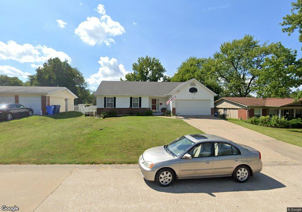
655 Millstone Dr Florissant, MO 63033
Estimated Value: $179,000 - $250,000
3
Beds
2
Baths
1,473
Sq Ft
$147/Sq Ft
Est. Value
About This Home
This home is located at 655 Millstone Dr, Florissant, MO 63033 and is currently estimated at $216,424, approximately $146 per square foot. 655 Millstone Dr is a home located in St. Louis County with nearby schools including Commons Lane Elementary School, Cross Keys Middle School, and McCluer North High School.
Ownership History
Date
Name
Owned For
Owner Type
Purchase Details
Closed on
Apr 28, 1999
Sold by
Cunningham Frederick A and Cunningham Tonya B
Bought by
Cunningham Frederick A
Current Estimated Value
Home Financials for this Owner
Home Financials are based on the most recent Mortgage that was taken out on this home.
Original Mortgage
$80,111
Outstanding Balance
$20,201
Interest Rate
6.99%
Estimated Equity
$196,223
Purchase Details
Closed on
Jan 29, 1997
Sold by
Hutcherson Bernard N and Hutcherson Elizabeth H
Bought by
Cunningham Frederick A and Cunningham Tonya B
Home Financials for this Owner
Home Financials are based on the most recent Mortgage that was taken out on this home.
Original Mortgage
$80,000
Interest Rate
7.64%
Create a Home Valuation Report for This Property
The Home Valuation Report is an in-depth analysis detailing your home's value as well as a comparison with similar homes in the area
Home Values in the Area
Average Home Value in this Area
Purchase History
| Date | Buyer | Sale Price | Title Company |
|---|---|---|---|
| Cunningham Frederick A | -- | -- | |
| Cunningham Frederick A | -- | -- |
Source: Public Records
Mortgage History
| Date | Status | Borrower | Loan Amount |
|---|---|---|---|
| Open | Cunningham Frederick A | $80,111 | |
| Closed | Cunningham Frederick A | $80,000 |
Source: Public Records
Tax History Compared to Growth
Tax History
| Year | Tax Paid | Tax Assessment Tax Assessment Total Assessment is a certain percentage of the fair market value that is determined by local assessors to be the total taxable value of land and additions on the property. | Land | Improvement |
|---|---|---|---|---|
| 2025 | $2,891 | $42,580 | $5,680 | $36,900 |
| 2024 | $2,891 | $37,520 | $3,740 | $33,780 |
| 2023 | $2,881 | $37,520 | $3,740 | $33,780 |
| 2022 | $2,647 | $30,300 | $5,680 | $24,620 |
| 2021 | $2,602 | $30,300 | $5,680 | $24,620 |
| 2020 | $2,472 | $27,000 | $5,680 | $21,320 |
| 2019 | $2,424 | $27,000 | $5,680 | $21,320 |
| 2018 | $2,417 | $24,060 | $1,730 | $22,330 |
| 2017 | $2,404 | $24,060 | $1,730 | $22,330 |
| 2016 | $2,418 | $23,580 | $2,490 | $21,090 |
| 2015 | $2,432 | $23,580 | $2,490 | $21,090 |
| 2014 | $2,494 | $24,980 | $4,140 | $20,840 |
Source: Public Records
Map
Nearby Homes
- 3475 Stonehaven Dr
- 3435 Saint Catherine St
- 3515 Saint Catherine St
- 990 Saddle Dr
- 670 Hargrove Ln
- 3140 Saint Catherine St
- 2520 Greenberry Dr
- 3270 Kingsley Dr
- 2320 Greenberry Dr
- 3150 Parker Rd
- 3190 N Waterford Dr
- 1945 Pohlman Rd
- 3940 Parker Rd
- 100 Broadmere Dr
- 2255 Wheatfield Dr
- 1540 Ascot Terrace
- 4040 Helmkampf Dr
- 265 Waterford Dr
- 2700 Suffolk Place
- 11849 Northport Dr
- 665 Millstone Dr
- 635 Millstone Dr
- 740 Saddle Dr
- 720 Saddle Dr
- 625 Millstone Dr
- 675 Millstone Dr
- 630 Millstone Dr
- 760 Saddle Dr
- 700 Saddle Dr
- 670 Millstone Dr
- 3490 Stonehaven Dr
- 620 Millstone Dr
- 3530 Bradstone Dr
- 615 Millstone Dr
- 670 Saddle Dr
- 780 Saddle Dr
- 3535 Bradstone Dr
- 690 Millstone Dr
- 3535 Brookstone Dr
- 3550 Bradstone Dr