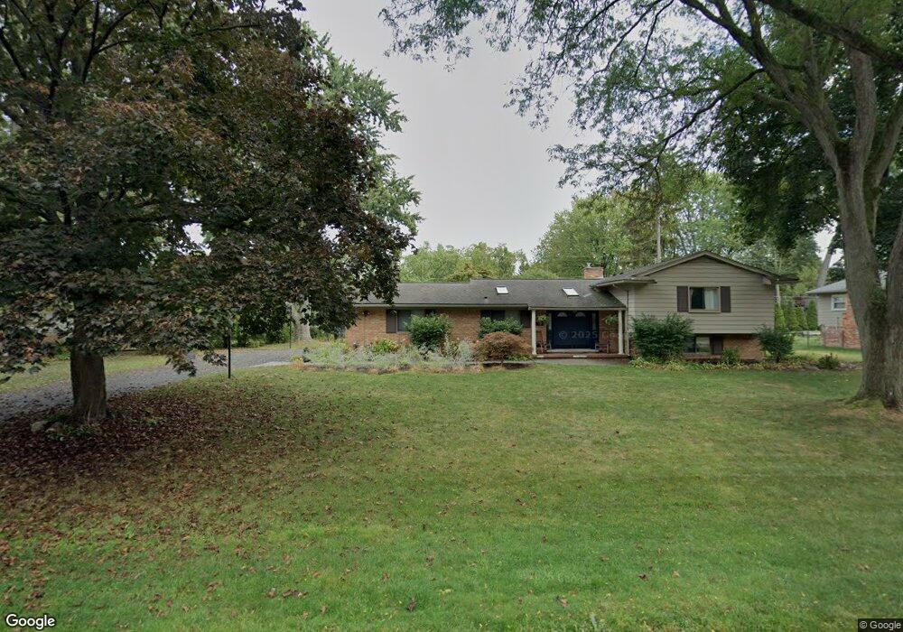
6555 Spruce Dr Unit Bldg-Unit Bloomfield Hills, MI 48301
Estimated Value: $470,852 - $596,000
4
Beds
3
Baths
2,307
Sq Ft
$231/Sq Ft
Est. Value
About This Home
This home is located at 6555 Spruce Dr Unit Bldg-Unit, Bloomfield Hills, MI 48301 and is currently estimated at $533,463, approximately $231 per square foot. 6555 Spruce Dr Unit Bldg-Unit is a home located in Oakland County with nearby schools including Conant Elementary School, South Hills Middle School, and Bloomfield Hills High School.
Ownership History
Date
Name
Owned For
Owner Type
Purchase Details
Closed on
Feb 20, 2018
Sold by
Stewart William B and Stewart Melissa P
Bought by
Indyk Timothy and Indyk Jeana
Current Estimated Value
Purchase Details
Closed on
Apr 29, 2008
Sold by
Penrice Susan A
Bought by
Stewart William B and Stewart Melissa P
Home Financials for this Owner
Home Financials are based on the most recent Mortgage that was taken out on this home.
Original Mortgage
$251,750
Interest Rate
5.93%
Mortgage Type
Purchase Money Mortgage
Purchase Details
Closed on
May 31, 1995
Sold by
Peck Reginald L
Bought by
Penrice Susan A
Home Financials for this Owner
Home Financials are based on the most recent Mortgage that was taken out on this home.
Original Mortgage
$152,000
Interest Rate
7.9%
Mortgage Type
New Conventional
Create a Home Valuation Report for This Property
The Home Valuation Report is an in-depth analysis detailing your home's value as well as a comparison with similar homes in the area
Home Values in the Area
Average Home Value in this Area
Purchase History
| Date | Buyer | Sale Price | Title Company |
|---|---|---|---|
| Indyk Timothy | $369,000 | Devon Title Agency | |
| Stewart William B | $265,000 | None Available | |
| Penrice Susan A | $190,000 | -- |
Source: Public Records
Mortgage History
| Date | Status | Borrower | Loan Amount |
|---|---|---|---|
| Previous Owner | Stewart William B | $251,750 | |
| Previous Owner | Penrice Susan A | $152,000 |
Source: Public Records
Tax History Compared to Growth
Tax History
| Year | Tax Paid | Tax Assessment Tax Assessment Total Assessment is a certain percentage of the fair market value that is determined by local assessors to be the total taxable value of land and additions on the property. | Land | Improvement |
|---|---|---|---|---|
| 2024 | $3,407 | $183,050 | $0 | $0 |
| 2023 | $3,438 | $181,790 | $0 | $0 |
| 2022 | $6,707 | $186,480 | $0 | $0 |
| 2021 | $6,659 | $174,410 | $0 | $0 |
| 2020 | $3,264 | $171,580 | $0 | $0 |
| 2019 | $6,446 | $173,240 | $0 | $0 |
| 2018 | $4,176 | $158,640 | $0 | $0 |
| 2017 | $4,146 | $154,370 | $0 | $0 |
| 2016 | $4,154 | $144,250 | $0 | $0 |
| 2015 | -- | $134,650 | $0 | $0 |
| 2014 | -- | $121,920 | $0 | $0 |
| 2011 | -- | $100,810 | $0 | $0 |
Source: Public Records
Map
Nearby Homes
- 6572 Spruce Dr
- 6660 Woodbank Dr
- 4200 Surrey Cross
- 750 Trailwood Path Unit B
- 450 Billingsgate Ct Unit C
- 1760 Trailwood Path
- 6750 Wing Lake Rd
- 4456 W Maple Rd
- 6952 Sandalwood Dr
- 7005 Cathedral Dr
- 6701 Franklin Rd
- 7100 Wing Lake Rd
- 4017 Hidden Woods Dr
- 7200 Telegraph Rd
- 6360 Hills Dr
- 7303 Brookside Village Ct
- 6450 Gilbert Lake Rd
- 4428 Old Trinity Ct
- 6720 Castle Dr
- 6041 Eastmoor Rd
- 6555 Spruce Dr
- 6579 Spruce Dr
- 6531 Spruce Dr
- 6554 Timber Ridge Dr
- 6576 Timber Ridge Dr
- 6532 Timber Ridge Dr
- 6550 Spruce Dr
- 6528 Spruce Dr
- 6611 Spruce Dr
- 6602 Timber Ridge Dr
- 6507 Spruce Dr
- 6604 Spruce Dr
- 6510 Timber Ridge Dr
- 6555 Timber Ridge Dr
- 6506 Spruce Dr
- 6624 Timber Ridge Dr
- 6577 Timber Ridge Dr
- 6533 Timber Ridge Dr
- 6633 Spruce Dr
- 6626 Spruce Dr