Estimated Value: $423,000 - $560,000
--
Bed
--
Bath
2,601
Sq Ft
$185/Sq Ft
Est. Value
About This Home
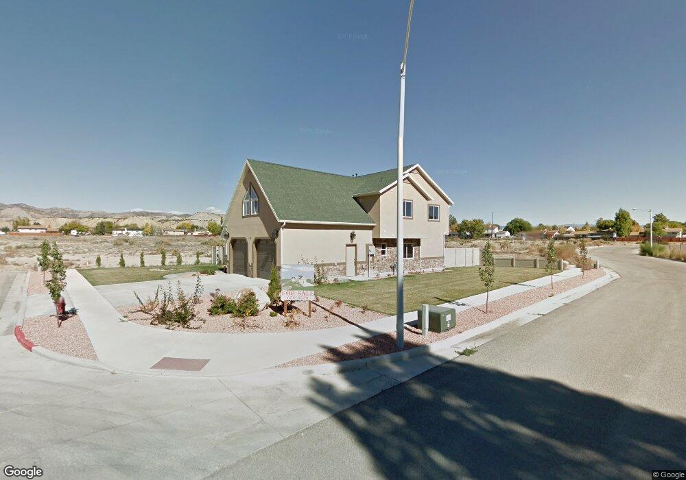
This home is located at 656 N 1400 E, Price, UT 84501 and is currently estimated at $480,129, approximately $184 per square foot. 656 N 1400 E is a home with nearby schools including Castle Heights School, Mont Harmon Junior High School, and Carbon High School.
Ownership History
Date
Name
Owned For
Owner Type
Purchase Details
Closed on
Sep 5, 2013
Sold by
Krompel Rick
Bought by
Kirkwood Quenten F and Kirkwood Bonnie A
Current Estimated Value
Home Financials for this Owner
Home Financials are based on the most recent Mortgage that was taken out on this home.
Original Mortgage
$274,500
Outstanding Balance
$202,523
Interest Rate
4.27%
Mortgage Type
New Conventional
Estimated Equity
$277,606
Create a Home Valuation Report for This Property
The Home Valuation Report is an in-depth analysis detailing your home's value as well as a comparison with similar homes in the area
Home Values in the Area
Average Home Value in this Area
Purchase History
| Date | Buyer | Sale Price | Title Company |
|---|---|---|---|
| Kirkwood Quenten F | -- | South Eastern Utah Title Co |
Source: Public Records
Mortgage History
| Date | Status | Borrower | Loan Amount |
|---|---|---|---|
| Open | Kirkwood Quenten F | $274,500 |
Source: Public Records
Tax History Compared to Growth
Tax History
| Year | Tax Paid | Tax Assessment Tax Assessment Total Assessment is a certain percentage of the fair market value that is determined by local assessors to be the total taxable value of land and additions on the property. | Land | Improvement |
|---|---|---|---|---|
| 2025 | $3,641 | $299,726 | $13,634 | $286,092 |
| 2024 | $3,164 | $263,431 | $12,788 | $250,643 |
| 2023 | $2,880 | $255,747 | $21,077 | $234,670 |
| 2022 | $3,012 | $239,950 | $17,524 | $222,426 |
| 2021 | $2,587 | $319,826 | $26,775 | $293,051 |
| 2020 | $2,537 | $157,402 | $0 | $0 |
| 2019 | $2,256 | $146,761 | $0 | $0 |
| 2018 | $2,124 | $140,956 | $0 | $0 |
| 2017 | $2,098 | $140,956 | $0 | $0 |
| 2016 | $1,892 | $140,956 | $0 | $0 |
| 2015 | $1,892 | $140,956 | $0 | $0 |
| 2014 | $1,879 | $140,956 | $0 | $0 |
| 2013 | $1,874 | $139,210 | $0 | $0 |
Source: Public Records
Map
Nearby Homes
- 688 Birch Cir
- 639 N 1550 E
- 1535 Sagewood Rd
- 703 N Windsor Cir
- 546 Windsor Rd
- 1689 Eastridge Rd
- 831 N 1820 E Unit 66
- 826 N 900 E
- 1827 E 8th N Unit 79
- 1830 E 840 N Unit 80
- 879 N 1820 E Unit 69
- 1841 E 8th N Unit 78
- 1840 E 840 N Unit 81
- 1829 E 840 N Unit 87
- 1855 E 8th N Unit 77
- 1858 E 840 N Unit 82
- 1843 E 840 N Unit 86
- 1857 E 840 N Unit 85
- 1871 E 840 N Unit 84
- 1860 E 880 N
- 1450 Sagewood Rd Unit 18
- 1450 Sagewood Rd Unit 14
- 1450 Sagewood Rd Unit 13
- 1450 Sagewood Rd Unit 11
- 1450 Sagewood Rd Unit 10
- 1450 Sagewood Rd Unit 9
- 1450 Sagewood Rd Unit 7
- 1450 Sagewood Rd Unit 5
- 1450 Sagewood Rd Unit 3
- 1450 Sagewood Rd Unit 2
- 1450 Sagewood Rd Unit 1
- 1450 Sagewood Rd Unit 16
- 1450 Sagewood Rd Unit 15
- 1453 Sagewood Rd
- 1483 Sagewood Rd
- 668 Birch Cir
- 676 Birch Cir
- 1515 Sagewood Rd
- 1376 Parkway Rd
- 626 Cedar Ln