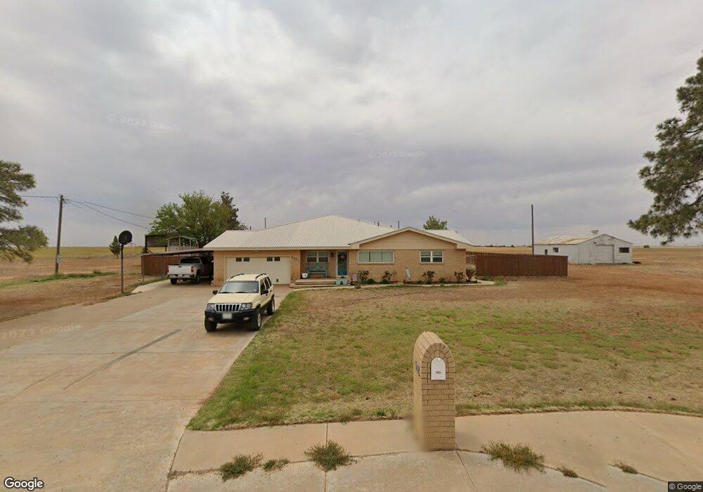
6564 Foster Rd Ropesville, TX 79358
Estimated Value: $300,000 - $609,000
3
Beds
2
Baths
2,627
Sq Ft
$148/Sq Ft
Est. Value
About This Home
This home is located at 6564 Foster Rd, Ropesville, TX 79358 and is currently estimated at $388,539, approximately $147 per square foot. 6564 Foster Rd is a home located in Hockley County with nearby schools including Ropes School.
Ownership History
Date
Name
Owned For
Owner Type
Purchase Details
Closed on
Jun 5, 2013
Sold by
Lowe Bill and Lowe Tina
Bought by
Drake Joel P and Drake Stephanie D
Current Estimated Value
Home Financials for this Owner
Home Financials are based on the most recent Mortgage that was taken out on this home.
Original Mortgage
$178,571
Outstanding Balance
$126,138
Interest Rate
3.41%
Mortgage Type
New Conventional
Estimated Equity
$262,401
Create a Home Valuation Report for This Property
The Home Valuation Report is an in-depth analysis detailing your home's value as well as a comparison with similar homes in the area
Purchase History
| Date | Buyer | Sale Price | Title Company |
|---|---|---|---|
| Drake Joel P | -- | None Available |
Source: Public Records
Mortgage History
| Date | Status | Borrower | Loan Amount |
|---|---|---|---|
| Open | Drake Joel P | $178,571 |
Source: Public Records
Tax History
| Year | Tax Paid | Tax Assessment Tax Assessment Total Assessment is a certain percentage of the fair market value that is determined by local assessors to be the total taxable value of land and additions on the property. | Land | Improvement |
|---|---|---|---|---|
| 2025 | $2,840 | $252,910 | $6,180 | $246,730 |
| 2024 | $3,814 | $235,680 | $5,630 | $230,050 |
| 2023 | $3,814 | $220,170 | $4,210 | $215,960 |
| 2022 | $3,971 | $188,780 | $4,210 | $184,570 |
| 2021 | $4,067 | $167,640 | $4,210 | $163,430 |
| 2020 | $3,690 | $161,770 | $4,210 | $157,560 |
| 2019 | $3,868 | $161,770 | $4,210 | $157,560 |
| 2018 | $3,785 | $158,250 | $4,210 | $154,040 |
| 2017 | $3,698 | $152,380 | $4,210 | $148,170 |
| 2016 | $3,513 | $144,760 | $4,210 | $140,550 |
| 2015 | -- | $140,070 | $4,210 | $135,860 |
| 2014 | -- | $134,170 | $4,210 | $129,960 |
Source: Public Records
Map
Nearby Homes
- 0 Parot Rd
- RFP, UNIT 3 Cooper Blvd
- 3898 Cooper Blvd
- 6787 Trump Ct
- 0 Steer Rd
- 0 Rockin T Rd Unit 202600317
- 0 Rockin T Rd Unit 202564755
- 0 Rockin T Rd Unit 202600240
- 0 Rockin T Rd Unit 202600239
- 0 Rockin T Rd Unit 202564738
- 0 Rockin T Rd Unit 202564743
- 0 Rockin T Rd Unit 202600406
- 0 Rockin T Rd Unit 202600315
- 0 Rockin T Rd Unit 202600407
- 0 Rockin T Rd Unit 202600314
- 0 Rockin T Rd Unit 202600316
- 0 Rockin T Rd Unit 202600402
- 0 Rockin T Rd Unit 202600238
- 0 Rockin T Rd Unit 202600237
- 0 Rockin T Rd Unit 202564746
- 6569 Foster Rd
- 6557 Foster Rd
- 6581 Foster Rd
- 6552 Foster Rd
- 6550 Foster Rd
- 6560 Foster Rd
- 6449 Rockin T Rd
- 6436 Rockin T Rd
- 6424 Rockin T Rd
- 6812 Parrot Rd
- 6690 Foster Rd
- 6418 Rockin T Rd
- 3923 Mallard Rd
- 3903 Mallard Rd
- 6555 Foster Rd
- 6641 Foster Rd
- 3910 Mallard Rd
- 0 Foster Rd Unit 9950574
- 0 Foster Rd Unit 9950539
- 0 Foster Rd Unit 9950540
Your Personal Tour Guide
Ask me questions while you tour the home.