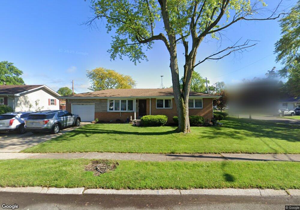
6568 Federal Ave Portage, IN 46368
Estimated Value: $250,000 - $270,000
4
Beds
2
Baths
1,230
Sq Ft
$212/Sq Ft
Est. Value
About This Home
This home is located at 6568 Federal Ave, Portage, IN 46368 and is currently estimated at $260,158, approximately $211 per square foot. 6568 Federal Ave is a home located in Porter County with nearby schools including Crisman Elementary School, Willowcreek Middle School, and Portage High School.
Ownership History
Date
Name
Owned For
Owner Type
Purchase Details
Closed on
May 25, 2006
Sold by
Shasteen Daniel L and Shasteen Gloria J
Bought by
Gentry James and Gentry Marjorie
Current Estimated Value
Home Financials for this Owner
Home Financials are based on the most recent Mortgage that was taken out on this home.
Original Mortgage
$145,255
Outstanding Balance
$91,351
Interest Rate
7.95%
Mortgage Type
Purchase Money Mortgage
Estimated Equity
$168,807
Create a Home Valuation Report for This Property
The Home Valuation Report is an in-depth analysis detailing your home's value as well as a comparison with similar homes in the area
Home Values in the Area
Average Home Value in this Area
Purchase History
| Date | Buyer | Sale Price | Title Company |
|---|---|---|---|
| Gentry James | -- | Ticor Title Insurance |
Source: Public Records
Mortgage History
| Date | Status | Borrower | Loan Amount |
|---|---|---|---|
| Open | Gentry James | $145,255 |
Source: Public Records
Tax History Compared to Growth
Tax History
| Year | Tax Paid | Tax Assessment Tax Assessment Total Assessment is a certain percentage of the fair market value that is determined by local assessors to be the total taxable value of land and additions on the property. | Land | Improvement |
|---|---|---|---|---|
| 2024 | $2,376 | $226,900 | $32,700 | $194,200 |
| 2023 | $2,080 | $232,000 | $31,300 | $200,700 |
| 2022 | $2,060 | $208,400 | $31,300 | $177,100 |
| 2021 | $1,738 | $174,000 | $31,300 | $142,700 |
| 2020 | $1,577 | $157,900 | $27,200 | $130,700 |
| 2019 | $1,481 | $148,300 | $27,200 | $121,100 |
| 2018 | $1,513 | $144,600 | $27,200 | $117,400 |
| 2017 | $1,407 | $141,100 | $27,200 | $113,900 |
| 2016 | $1,376 | $133,200 | $33,800 | $99,400 |
| 2014 | $1,363 | $130,400 | $33,400 | $97,000 |
| 2013 | -- | $133,000 | $34,200 | $98,800 |
Source: Public Records
Map
Nearby Homes
- 2191 Hamilton St
- 2262 Rodeo St
- 6686 Portage Ave
- 6697 Federal Ave
- 2065 Jefferson St
- 6666 Vienna Ave
- 2161 Hamstrom Rd
- 2408 Doretta St
- 2182 Foley St
- 2183 Foley St
- 2230 Foley St
- 2410 Norman St
- 6698 Monument Ave
- 6665 Lakewood Ave
- 6654 Hawthorne Ave
- 1959 Greentree St
- 2400 Hamstrom Rd
- 1943 Samuelson Rd
- 0 Airport Us 6 Unit NRA806028
- 0 Central Ave Unit NRA826855
- 6560 Federal Ave
- 2206 Capitol St
- 2215 Capitol St
- 2209 Capitol St
- 6554 Federal Ave
- 2196 Capitol St
- 6567 Federal Ave
- 2205 Pennsylvania St
- 6573 Federal Ave
- 2203 Capitol St
- 6559 Federal Ave
- 6581 Federal Ave
- 2199 Pennsylvania St
- 6553 Federal Ave
- 2201 Capitol St
- 2190 Capitol St
- 6592 Federal Ave
- 6583 Federal Ave
- 2199 Capitol St
- 2191 Pennsylvania St