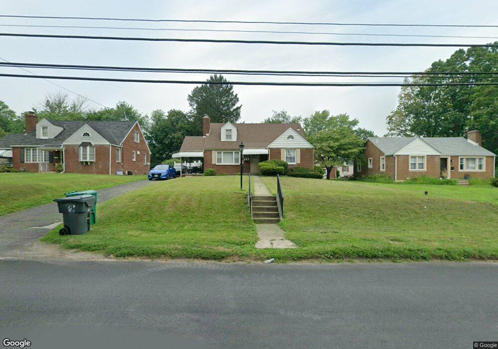
657 Forrest Ave Norristown, PA 19401
Estimated Value: $276,000 - $449,000
4
Beds
2
Baths
1,501
Sq Ft
$236/Sq Ft
Est. Value
About This Home
This home is located at 657 Forrest Ave, Norristown, PA 19401 and is currently estimated at $354,823, approximately $236 per square foot. 657 Forrest Ave is a home located in Montgomery County with nearby schools including Charles Blockson Middle School, Marshall Street Elementary School, and East Norriton Middle School.
Ownership History
Date
Name
Owned For
Owner Type
Purchase Details
Closed on
Jan 12, 2007
Sold by
Mcgoldrick Nancy L and Russo Joseph M
Bought by
Lemke Jamise J and Lemke Jeremiah H
Current Estimated Value
Home Financials for this Owner
Home Financials are based on the most recent Mortgage that was taken out on this home.
Original Mortgage
$185,250
Outstanding Balance
$110,335
Interest Rate
6.15%
Estimated Equity
$244,488
Purchase Details
Closed on
Jun 10, 2005
Sold by
Perna Antonetta
Bought by
Mcgoldrick Nancy L and Russo Joseph M
Create a Home Valuation Report for This Property
The Home Valuation Report is an in-depth analysis detailing your home's value as well as a comparison with similar homes in the area
Home Values in the Area
Average Home Value in this Area
Purchase History
| Date | Buyer | Sale Price | Title Company |
|---|---|---|---|
| Lemke Jamise J | $200,000 | None Available | |
| Mcgoldrick Nancy L | -- | -- |
Source: Public Records
Mortgage History
| Date | Status | Borrower | Loan Amount |
|---|---|---|---|
| Open | Lemke Jamise J | $185,250 |
Source: Public Records
Tax History Compared to Growth
Tax History
| Year | Tax Paid | Tax Assessment Tax Assessment Total Assessment is a certain percentage of the fair market value that is determined by local assessors to be the total taxable value of land and additions on the property. | Land | Improvement |
|---|---|---|---|---|
| 2025 | $5,632 | $115,260 | $36,710 | $78,550 |
| 2024 | $5,632 | $115,260 | $36,710 | $78,550 |
| 2023 | $5,568 | $115,260 | $36,710 | $78,550 |
| 2022 | $5,532 | $115,260 | $36,710 | $78,550 |
| 2021 | $5,498 | $115,260 | $36,710 | $78,550 |
| 2020 | $5,334 | $115,260 | $36,710 | $78,550 |
| 2019 | $5,215 | $115,260 | $36,710 | $78,550 |
| 2018 | $4,009 | $115,260 | $36,710 | $78,550 |
| 2017 | $4,923 | $115,260 | $36,710 | $78,550 |
| 2016 | $4,879 | $115,260 | $36,710 | $78,550 |
| 2015 | $4,519 | $115,260 | $36,710 | $78,550 |
| 2014 | $4,519 | $115,260 | $36,710 | $78,550 |
Source: Public Records
Map
Nearby Homes
- 417 Centre Ave
- 0 Centre Unit 430 PAMC2099854
- 606 Selma St
- 609 Glen Ln Unit 54-B
- 612 Glen Ln Unit 56A
- 564 Hamilton St
- 633 Glen Ln Unit 66B
- 805 Northridge Dr Unit 108-B
- 0 Sheridan Ln Unit PAMC2130926
- 0 Sheridan Ln Unit PAMC2131012
- 1635 W Marshall W Marshall St
- 134 W Main St
- 1016 Thomas Barone St
- 1402 Sterigere St
- 122 N Prospect Ave
- 108 N Prospect Ave
- 905 W Marshall St
- 909 Noble St
- 137 Avondale Rd
- 1009 W Main St
- 655 Forrest Ave
- 667 N Forrest Ave
- 667 Forrest Ave
- 1400 W Oak St
- 653 Forrest Ave
- 1400 Buchannon Ave
- 635 Forrest Ave
- 673 Forrest Ave
- 633 Forrest Ave
- 1339 W Oak St
- 629 Forrest Ave
- 627 Forrest Ave
- 1337 W Oak St
- 304 Centre Ave
- 301 Centre Ave
- 623 Forrest Ave
- 306 Centre Ave
- 202 Centre Ave
- 205 Centre Ave Unit 205
- 201 Centre Ave