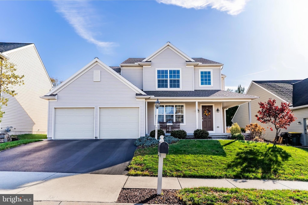

657 Hamaker Rd Manheim, PA 17545
Estimated payment $3,062/month
Highlights
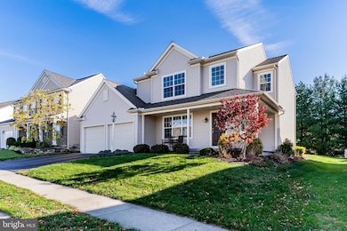
- Colonial Architecture
- 1 Fireplace
- 2 Car Direct Access Garage
- Vaulted Ceiling
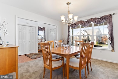
- Breakfast Room
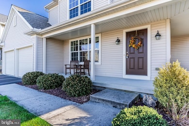
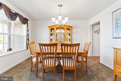
- Living Room
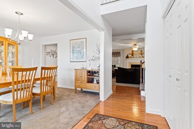
About This Home
Welcome to this beautifully maintained 4-bedroom, 2.5-bath home located in the desirable Baron’s Ridge neighborhood within the Manheim Central School District. A bright, vaulted foyer greets you upon entry, leading into a spacious main level that includes a well-appointed kitchen, inviting dining room, and comfortable living room perfect for everyday living or entertaining. Convenience meets functionality with a first-floor laundry room and a true 2-car garage offering ample storage. Step outside to enjoy a nice, flat yard, perfect for outdoor activities, gardening, or relaxing. All bedrooms feature ceiling fans, and both full bathrooms include double vanities for added comfort. The finished basement provides valuable additional living space, ideal for a media room, playroom, home office, or gym. Roof and water heater have been replaced within the last 3 years. This home offers a wonderful blend of space, comfort, and location. Ready for its next owners to move right in!
Listing Agent
(717) 557-9312 ccastner@rsrrealtors.com RSR, REALTORS, LLC License #RS323860 Listed on: 11/17/2025
Home Details
Home Type
- Single Family
Est. Annual Taxes
- $5,681
Year Built
- Built in 2009
Lot Details
- 9,148 Sq Ft Lot
HOA Fees
- $13 Monthly HOA Fees
Parking
- 2 Car Direct Access Garage
- Front Facing Garage
- Driveway
- On-Street Parking
- Off-Street Parking
Home Design
- Colonial Architecture
- Traditional Architecture
- Frame Construction
- Vinyl Siding
- Concrete Perimeter Foundation
Interior Spaces
- Property has 2 Levels
- Vaulted Ceiling
- 1 Fireplace
- Entrance Foyer
- Family Room
- Living Room
- Breakfast Room
- Dining Room
- Partially Finished Basement
- Basement Fills Entire Space Under The House
Bedrooms and Bathrooms
- 4 Bedrooms
Laundry
- Laundry Room
- Laundry on main level
Utilities
- Forced Air Heating and Cooling System
- Electric Water Heater
Community Details
- Association fees include road maintenance, common area maintenance
- Baron's Ridge Homeowners Association
- Barons Ridge Subdivision
Listing and Financial Details
- Assessor Parcel Number 500-88999-0-0000
Map
Home Values in the Area
Average Home Value in this Area
Tax History
| Year | Tax Paid | Tax Assessment Tax Assessment Total Assessment is a certain percentage of the fair market value that is determined by local assessors to be the total taxable value of land and additions on the property. | Land | Improvement |
|---|---|---|---|---|
| 2025 | $5,390 | $264,400 | $57,500 | $206,900 |
| 2024 | $5,390 | $264,400 | $57,500 | $206,900 |
| 2023 | $5,277 | $264,400 | $57,500 | $206,900 |
| 2022 | $5,141 | $264,400 | $57,500 | $206,900 |
| 2021 | $5,025 | $264,400 | $57,500 | $206,900 |
| 2020 | $5,025 | $264,400 | $57,500 | $206,900 |
| 2019 | $4,938 | $264,400 | $57,500 | $206,900 |
| 2018 | $3,673 | $264,400 | $57,500 | $206,900 |
| 2017 | $6,289 | $269,800 | $38,600 | $231,200 |
| 2016 | $6,289 | $269,800 | $38,600 | $231,200 |
| 2015 | $1,493 | $269,800 | $38,600 | $231,200 |
| 2014 | $4,515 | $269,800 | $38,600 | $231,200 |
Property History
| Date | Event | Price | List to Sale | Price per Sq Ft |
|---|---|---|---|---|
| 11/29/2025 11/29/25 | Pending | -- | -- | -- |
| 11/17/2025 11/17/25 | For Sale | $489,900 | -- | $177 / Sq Ft |
Purchase History
| Date | Type | Sale Price | Title Company |
|---|---|---|---|
| Deed | $275,422 | None Available |
Mortgage History
| Date | Status | Loan Amount | Loan Type |
|---|---|---|---|
| Closed | $65,000 | New Conventional |
Source: Bright MLS
MLS Number: PALA2079774
APN: 500-88999-0-0000
Disclaimer: Certain information contained herein is derived from information provided by parties other than Homes.com. All information provided is deemed reliable, but is not guaranteed to be accurate and should be independently verified.
![]() The data relating to real estate for sale on this website appears in part through the BRIGHT Internet Data Exchange program, a voluntary cooperative exchange of property listing data between licensed real estate brokerage firms, and is provided by BRIGHT through a licensing agreement.
The data relating to real estate for sale on this website appears in part through the BRIGHT Internet Data Exchange program, a voluntary cooperative exchange of property listing data between licensed real estate brokerage firms, and is provided by BRIGHT through a licensing agreement.
Listing information is from various brokers who participate in the Bright MLS IDX program and not all listings may be visible on the site.
The property information being provided on or through the website is for the personal, non-commercial use of consumers and such information may not be used for any purpose other than to identify prospective properties consumers may be interested in purchasing.
Some properties which appear for sale on the website may no longer be available because they are for instance, under contract, sold or are no longer being offered for sale.
Property information displayed is deemed reliable but is not guaranteed.
Copyright 2025 Bright MLS, Inc.
- 489 Wood Duck Dr
- 609 Hamaker Rd
- 714 Heather Ridge Unit 140
- 854 Cambridge Dr Unit 7
- 988 Cambridge Dr
- 68 Daffodil Dr
- 130 Julia Ln
- 222 E High St
- 187 N Hazel St
- 162 N Charlotte St
- 57 N Charlotte St
- 508 Rambler Rd
- 157 S Wolf St
- 216 N Pitt St
- 173 S Wolf St
- 108 110 S Main St
- 2 S Charlotte St
- 144 Rapho St
- 27 W Ferdinand St
- 43 W Ferdinand St
