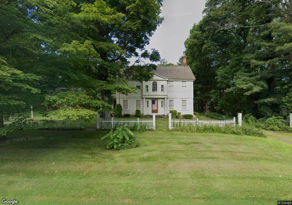
657 Main St N Southbury, CT 06488
Estimated Value: $607,023 - $835,000
--
Bed
--
Bath
--
Sq Ft
1.52
Acres
About This Home
This home is located at 657 Main St N, Southbury, CT 06488 and is currently estimated at $704,256. 657 Main St N is a home located in New Haven County with nearby schools including Long Meadow Elementary School, Memorial Middle School, and Pomperaug Regional High School.
Ownership History
Date
Name
Owned For
Owner Type
Purchase Details
Closed on
Aug 3, 1993
Sold by
American Bank Of Ct
Bought by
Capter James
Current Estimated Value
Home Financials for this Owner
Home Financials are based on the most recent Mortgage that was taken out on this home.
Original Mortgage
$150,000
Interest Rate
7.32%
Mortgage Type
Unknown
Purchase Details
Closed on
May 30, 1991
Sold by
Maxfield Allen and Maxfield Karen
Bought by
American Bk Of Ct
Create a Home Valuation Report for This Property
The Home Valuation Report is an in-depth analysis detailing your home's value as well as a comparison with similar homes in the area
Home Values in the Area
Average Home Value in this Area
Purchase History
| Date | Buyer | Sale Price | Title Company |
|---|---|---|---|
| Capter James | $275,000 | -- | |
| American Bk Of Ct | $370,746 | -- |
Source: Public Records
Mortgage History
| Date | Status | Borrower | Loan Amount |
|---|---|---|---|
| Open | American Bk Of Ct | $161,000 | |
| Closed | American Bk Of Ct | $146,000 | |
| Closed | American Bk Of Ct | $150,000 |
Source: Public Records
Tax History Compared to Growth
Tax History
| Year | Tax Paid | Tax Assessment Tax Assessment Total Assessment is a certain percentage of the fair market value that is determined by local assessors to be the total taxable value of land and additions on the property. | Land | Improvement |
|---|---|---|---|---|
| 2025 | $8,708 | $359,830 | $78,550 | $281,280 |
| 2024 | $8,492 | $359,830 | $78,550 | $281,280 |
| 2023 | $8,096 | $359,830 | $78,550 | $281,280 |
| 2022 | $8,024 | $280,170 | $70,790 | $209,380 |
| 2021 | $8,209 | $280,170 | $70,790 | $209,380 |
| 2020 | $8,209 | $280,170 | $70,790 | $209,380 |
| 2019 | $8,153 | $280,170 | $70,790 | $209,380 |
| 2018 | $8,125 | $280,170 | $70,790 | $209,380 |
| 2017 | $9,419 | $321,470 | $80,030 | $241,440 |
| 2016 | $9,258 | $321,470 | $80,030 | $241,440 |
| 2015 | $9,130 | $321,470 | $80,030 | $241,440 |
| 2014 | $8,873 | $321,470 | $80,030 | $241,440 |
Source: Public Records
Map
Nearby Homes
- 33 Old Field Hill Rd Unit 12
- 33 Old Field Hill Rd Unit 37
- 527 Heritage Village Unit A
- 227 Dublin Hill Rd
- 517 Heritage Village Unit D
- 515 Heritage Village Unit A
- 512 Heritage Village Unit B
- 510 Heritage Village Unit B
- 511 Heritage Village Unit B
- 1 Heritage Village Unit C
- 575 Heritage Village Unit A
- 626 Heritage Village
- 106 Bates Rock Rd
- 101 Settlers Hill Rd
- 568 Heritage Village
- 51 Heritage Village Unit B
- 643 Heritage Village Unit A
- 623 Heritage Village Unit B
- 644 Heritage Village Unit A
- 57 Heritage Village Unit B
- 657 Main St N
- 695 Main St N
- 660 Main St N
- 921 Old Field Rd
- 933 Old Field Rd
- 617 Main St N
- 688 Main St N
- 903 Old Field Rd
- 31 Hinman Ln W
- 913 Old Field Rd
- 602 Main St N
- 995 Old Field Rd
- 738 Main St N
- 853 Old Field Rd
- 571 Main St N
- 43 Hinman Ln W
- 604 Main St N
- 718 Main St N
- 835 Old Field Rd
- 576 Main St N