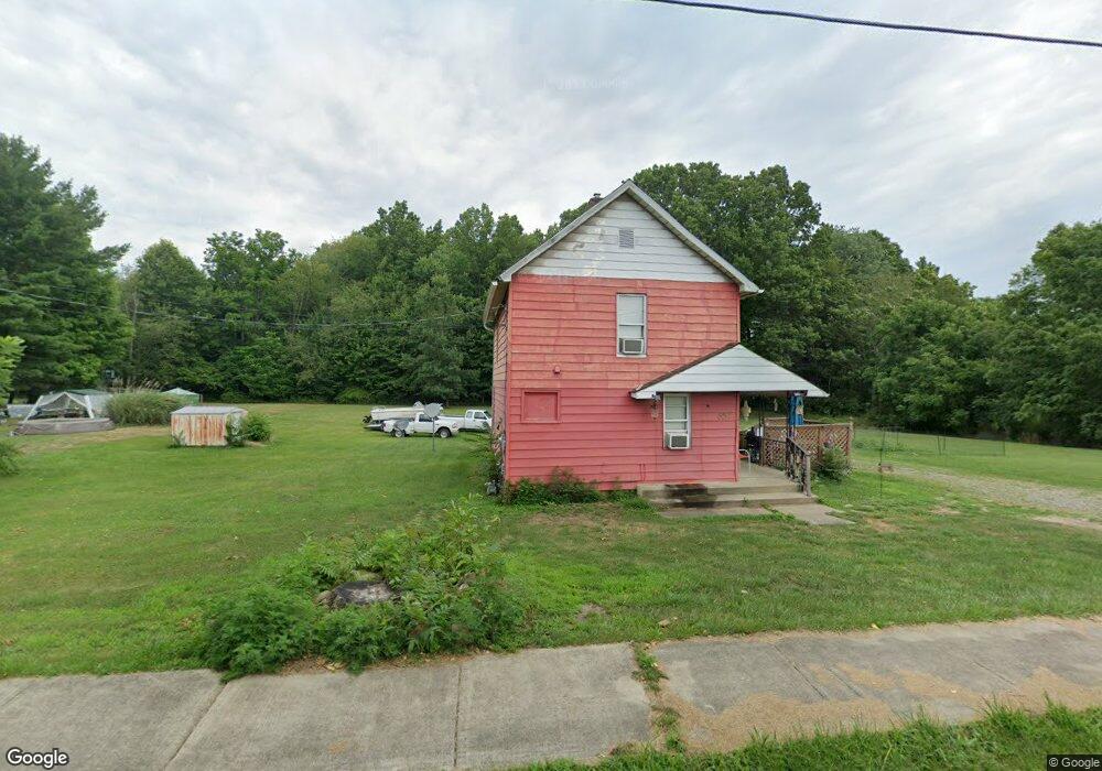
657 W Harrison St Alliance, OH 44601
Estimated Value: $76,477 - $94,000
2
Beds
1
Bath
990
Sq Ft
$85/Sq Ft
Est. Value
About This Home
This home is located at 657 W Harrison St, Alliance, OH 44601 and is currently estimated at $84,369, approximately $85 per square foot. 657 W Harrison St is a home located in Stark County with nearby schools including Alliance Early Learning School, Alliance Intermediate School at Northside, and Alliance Middle School.
Ownership History
Date
Name
Owned For
Owner Type
Purchase Details
Closed on
Apr 25, 2011
Sold by
Shanks Richard S and Shanks Linda S
Bought by
Rinda Properties Llc
Current Estimated Value
Purchase Details
Closed on
Jan 24, 2008
Sold by
Shanks Linda
Bought by
Shanks Linda and Shanks Richard S
Purchase Details
Closed on
May 21, 2007
Sold by
Hud
Bought by
Shanks Linda
Purchase Details
Closed on
Oct 12, 2006
Sold by
Moore Sharon K
Bought by
Hud
Purchase Details
Closed on
Mar 20, 1995
Sold by
Kress Richard A
Bought by
Pfeil Christopher S
Home Financials for this Owner
Home Financials are based on the most recent Mortgage that was taken out on this home.
Original Mortgage
$34,217
Interest Rate
8.97%
Mortgage Type
FHA
Purchase Details
Closed on
Feb 25, 1992
Create a Home Valuation Report for This Property
The Home Valuation Report is an in-depth analysis detailing your home's value as well as a comparison with similar homes in the area
Home Values in the Area
Average Home Value in this Area
Purchase History
| Date | Buyer | Sale Price | Title Company |
|---|---|---|---|
| Rinda Properties Llc | -- | None Available | |
| Shanks Linda | -- | Patriot Title Agency Inc | |
| Shanks Linda | $24,000 | Lakeside Title & Escrow Agen | |
| Hud | $30,000 | None Available | |
| Pfeil Christopher S | $34,500 | -- | |
| -- | -- | -- |
Source: Public Records
Mortgage History
| Date | Status | Borrower | Loan Amount |
|---|---|---|---|
| Previous Owner | Pfeil Christopher S | $34,217 |
Source: Public Records
Tax History Compared to Growth
Tax History
| Year | Tax Paid | Tax Assessment Tax Assessment Total Assessment is a certain percentage of the fair market value that is determined by local assessors to be the total taxable value of land and additions on the property. | Land | Improvement |
|---|---|---|---|---|
| 2025 | -- | $11,800 | $7,140 | $4,660 |
| 2024 | -- | $11,800 | $7,140 | $4,660 |
| 2023 | $474 | $11,520 | $4,380 | $7,140 |
| 2022 | $477 | $11,520 | $4,380 | $7,140 |
| 2021 | $479 | $11,520 | $4,380 | $7,140 |
| 2020 | $398 | $8,960 | $3,570 | $5,390 |
| 2019 | $393 | $8,960 | $3,570 | $5,390 |
| 2018 | $395 | $8,960 | $3,570 | $5,390 |
| 2017 | $363 | $8,090 | $3,500 | $4,590 |
| 2016 | $366 | $8,090 | $3,500 | $4,590 |
| 2015 | $417 | $9,140 | $3,500 | $5,640 |
| 2014 | $411 | $8,580 | $3,290 | $5,290 |
| 2013 | $205 | $8,580 | $3,290 | $5,290 |
Source: Public Records
Map
Nearby Homes
- 511 W Ely St
- 432 Johnson Ave
- 329 1/2 W Main St
- 345 W Market St
- 000 Meadowbrook Ave
- 000 Klinger Ave
- 163 W Market St
- 132 S Haines Ave
- 0 Meadowbrook Ave
- 710 N Freedom Ave
- 124 E Wayne St
- 725 W Summit St
- 645 W Summit St
- 0 Homestead Ave NE
- 734 Parkway Blvd
- 427 S Union Ave
- 0 Johnson Ave NE Unit 5142926
- 140 W Summit St
- 0 Klinger Ave NE
- 896 Parkway Blvd
- 663 W Harrison St
- 687 W Harrison St
- 687 W Harrison St
- 687 W Harrison St
- 414 N Rockhill Ave
- 414 N Rockhill Ave
- 406 N Rockhill Ave
- 428 N Rockhill Ave
- 697 W Harrison St
- 436 N Rockhill Ave
- 360 N Rockhill Ave
- 354 N Rockhill Ave
- 701 W Harrison St
- 723 W Harrison St
- 588 W Harrison St
- 351 N Rockhill Ave
- 335 N Rockhill Ave
- 443 N Rockhill Ave
- 304 N Rockhill Ave
- 567 W Harrison St