Estimated Value: $295,000 - $321,000
3
Beds
2
Baths
1,040
Sq Ft
$295/Sq Ft
Est. Value
About This Home
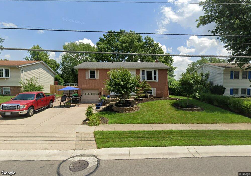
This home is located at 6572 Butler Warren Rd, Mason, OH 45040 and is currently estimated at $306,767, approximately $294 per square foot. 6572 Butler Warren Rd is a home located in Warren County with nearby schools including Mason Intermediate Elementary School, Mason Middle School, and William Mason High School.
Ownership History
Date
Name
Owned For
Owner Type
Purchase Details
Closed on
Mar 27, 2006
Sold by
Brickett Timothy M and Bricket Susan J
Bought by
Brickett Timothy M
Current Estimated Value
Home Financials for this Owner
Home Financials are based on the most recent Mortgage that was taken out on this home.
Original Mortgage
$137,000
Outstanding Balance
$78,820
Interest Rate
6.38%
Mortgage Type
Fannie Mae Freddie Mac
Estimated Equity
$227,947
Purchase Details
Closed on
Oct 11, 1994
Sold by
Watts Fred
Bought by
Brickett Timothy M and Brickett Susan J
Home Financials for this Owner
Home Financials are based on the most recent Mortgage that was taken out on this home.
Original Mortgage
$89,877
Interest Rate
8.64%
Mortgage Type
FHA
Create a Home Valuation Report for This Property
The Home Valuation Report is an in-depth analysis detailing your home's value as well as a comparison with similar homes in the area
Home Values in the Area
Average Home Value in this Area
Purchase History
| Date | Buyer | Sale Price | Title Company |
|---|---|---|---|
| Brickett Timothy M | -- | Title Resolutions | |
| Brickett Timothy M | $90,000 | -- |
Source: Public Records
Mortgage History
| Date | Status | Borrower | Loan Amount |
|---|---|---|---|
| Open | Brickett Timothy M | $137,000 | |
| Closed | Brickett Timothy M | $89,877 |
Source: Public Records
Tax History Compared to Growth
Tax History
| Year | Tax Paid | Tax Assessment Tax Assessment Total Assessment is a certain percentage of the fair market value that is determined by local assessors to be the total taxable value of land and additions on the property. | Land | Improvement |
|---|---|---|---|---|
| 2024 | $2,821 | $79,310 | $24,500 | $54,810 |
| 2023 | $2,431 | $59,363 | $10,762 | $48,601 |
| 2022 | $2,815 | $59,364 | $10,763 | $48,601 |
| 2021 | $2,667 | $59,364 | $10,763 | $48,601 |
| 2020 | $2,528 | $48,262 | $8,750 | $39,512 |
| 2019 | $2,324 | $48,262 | $8,750 | $39,512 |
| 2018 | $2,332 | $48,262 | $8,750 | $39,512 |
| 2017 | $2,151 | $41,552 | $8,274 | $33,278 |
| 2016 | $2,215 | $41,552 | $8,274 | $33,278 |
| 2015 | $2,220 | $41,552 | $8,274 | $33,278 |
| 2014 | $2,225 | $38,830 | $7,730 | $31,100 |
| 2013 | $2,230 | $43,950 | $8,750 | $35,200 |
Source: Public Records
Map
Nearby Homes
- 921 Leslie Ct
- 873 Tradewind Dr
- 947 Olympia Dr
- 7986 Tylers Way
- 6955 Grand Oaks Ct
- 7843 Butler Warren Rd
- 6070 Fireside Dr Unit 45
- 8500 Crestmont Dr
- 8430 Meadowlark Ct
- 6356 Amber Ct Unit 91
- 8617 Alexander Ct
- 6138 Nicholas Way
- 6387 Coverage Ct
- 6369 Coverage Ct
- 6403 Coverage Ct
- 6357 Coverage Ct
- 6383 Coverage Ct
- 6407 Coverage Ct
- 6375 Coverage Ct
- 6365 Coverage Ct
- 6584 Butler Warren Rd
- 1476 Windsong Ct
- 6600 Butler Warren Rd
- 1475 Windsong Ct
- 6542 Butler Warren Rd
- 1485 Windward Dr
- 1472 Windsong Ct
- 8373 Ironside Ct
- 6608 Butler Warren Rd
- 1479 Windward Dr
- 1471 Windsong Ct
- 8363 Ironside Ct
- 1475 Windward Dr
- 1466 Windsong Ct
- 1482 Southwind Dr
- 8383 Ironside Ct
- 1494 Southwind Dr
- 1474 Southwind Dr
- 1465 Windsong Ct
- 1465 Windward Dr