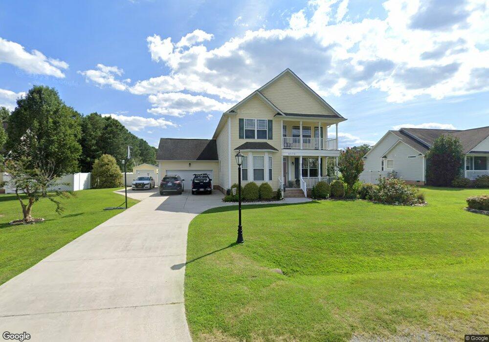
6572 Wysteria Ln Gloucester, VA 23061
Estimated Value: $494,418 - $521,000
5
Beds
3
Baths
2,704
Sq Ft
$188/Sq Ft
Est. Value
About This Home
This home is located at 6572 Wysteria Ln, Gloucester, VA 23061 and is currently estimated at $508,355, approximately $188 per square foot. 6572 Wysteria Ln is a home located in Gloucester County with nearby schools including Botetourt Elementary School, Page Middle School, and Gloucester High School.
Ownership History
Date
Name
Owned For
Owner Type
Purchase Details
Closed on
May 5, 2010
Sold by
Dunston Hall Llc
Bought by
Petrowicz Julian J and Petrowicz Tammy C
Current Estimated Value
Home Financials for this Owner
Home Financials are based on the most recent Mortgage that was taken out on this home.
Original Mortgage
$250,593
Outstanding Balance
$166,904
Interest Rate
5%
Mortgage Type
VA
Estimated Equity
$341,451
Create a Home Valuation Report for This Property
The Home Valuation Report is an in-depth analysis detailing your home's value as well as a comparison with similar homes in the area
Home Values in the Area
Average Home Value in this Area
Purchase History
| Date | Buyer | Sale Price | Title Company |
|---|---|---|---|
| Petrowicz Julian J | $285,000 | -- |
Source: Public Records
Mortgage History
| Date | Status | Borrower | Loan Amount |
|---|---|---|---|
| Open | Petrowicz Julian J | $250,593 |
Source: Public Records
Tax History
| Year | Tax Paid | Tax Assessment Tax Assessment Total Assessment is a certain percentage of the fair market value that is determined by local assessors to be the total taxable value of land and additions on the property. | Land | Improvement |
|---|---|---|---|---|
| 2025 | $2,634 | $422,100 | $94,080 | $328,020 |
| 2024 | $2,634 | $422,100 | $94,080 | $328,020 |
| 2023 | $2,503 | $422,100 | $94,080 | $328,020 |
| 2022 | $2,408 | $327,600 | $71,300 | $256,300 |
| 2021 | $2,310 | $327,600 | $71,300 | $256,300 |
| 2020 | $2,310 | $327,600 | $71,300 | $256,300 |
| 2019 | $1,972 | $279,700 | $74,160 | $205,540 |
| 2017 | $1,972 | $279,700 | $74,160 | $205,540 |
| 2016 | $1,997 | $283,240 | $74,160 | $209,080 |
| 2015 | $1,954 | $298,600 | $53,000 | $245,600 |
| 2014 | $1,954 | $296,000 | $53,000 | $243,000 |
Source: Public Records
Map
Nearby Homes
- 6123 Roland Smith Dr
- 6504 Gentry Ct
- 6467 Fleming Rilee Ln
- 5941 Roland Smith Dr
- 0000 T C Walker Rd
- 6525 Hickory Knoll Rd
- 6115 Prospect Rd
- 5996 T C Walker Rd
- 38+AC Burleigh Rd
- 6876 Motley Landing Dr
- 6887 Healy Ave
- 6915 Healy Ave
- Lot 2 S George Washington Memorial Hwy
- 17 S George Washington Memorial Hwy
- Lot 3 S George Washington Memorial Hwy
- 6964 Motley Landing Dr
- 00 Mill Ln
- 1.97ac Mill Ln
- 5474 George Washington Memorial Hwy
- 10+AC Whitetail Dr
- 6562 Wysteria Ln
- 6584 Wysteria Ln
- 6575 Wysteria Ln
- 6113 Roland Smith Dr
- 6565 Wysteria Ln
- 6545 Gentry Ct
- 6136 Roland Smith Dr
- 6538 Wysteria Ln
- 6589 Wysteria Ln
- 6103 Roland Smith Dr
- 6543 Wysteria Ln
- 6181 Roland Smith Dr
- 6532 Gentry Ct
- 6535 Gentry Ct
- 6091 Roland Smith Dr
- 6091 Roland Smith Dr Unit SMITH
- 6588 Clayton Ct
- 6178 Roland Smith Dr
- 6191 Roland Smith Dr
- 6529 Wysteria Ln
Your Personal Tour Guide
Ask me questions while you tour the home.