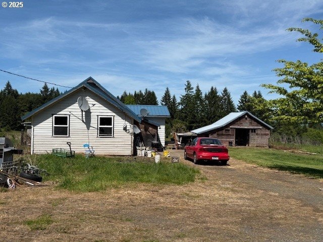


65748 Meissner Rd Deer Island, OR 97054
Estimated payment $2,417/month
Highlights
- Barn
- 10.32 Acre Lot
- Farmhouse Style Home
- RV Access or Parking
- Territorial View
- No HOA
About This Home
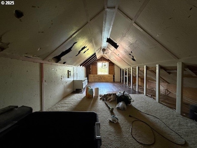
Discover the incredible potential awaiting you on this expansive 10.32-acre parcel, offering entirely flat and highly versatile land perfect for agricultural pursuits, equestrian dreams, or creating your ultimate private estate. This unique property features a substantial historic dairy barn with a partial concrete floor, ideal for a multitude of uses from storage to creative ventures. Additionally, a large pump house provides a dedicated workspace and utility. Both the home and barn boast durable metal roofs, ensuring longevity. Wake up to breathtaking, unobstructed views of majestic Mt. St. Helens, providing a stunning backdrop to your new rural lifestyle.The existing home is ready for your personal touch and vision, offering a blank canvas to transform it into your dream residence. Property is being sold strictly "as-is," and the Seller will not be performing any repairs.
Home Details
Home Type
- Single Family
Est. Annual Taxes
- $1,503
Year Built
- Built in 1930
Lot Details
- 10.32 Acre Lot
- Fenced
- Level Lot
- Landscaped with Trees
- Property is zoned RR-5
Home Design
- Farmhouse Style Home
- Metal Roof
- Wood Siding
- Concrete Perimeter Foundation
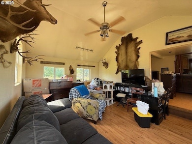
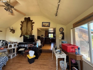
Interior Spaces
- 1,460 Sq Ft Home
- 3-Story Property
- Double Pane Windows
- Family Room
- Living Room
- Dining Room
- Territorial Views
- Basement Fills Entire Space Under The House
Kitchen
- Built-In Oven
- Cooktop
- Microwave
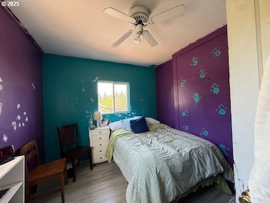
Bedrooms and Bathrooms
- 2 Bedrooms
Parking
- Off-Street Parking
- RV Access or Parking
Schools
- Mcbride Elementary School
- St Helens Middle School
- St Helens High School
Utilities
- No Cooling
- Wall Furnace
- Well
- Electric Water Heater
Additional Features
- Outbuilding
- Barn
Community Details
- No Home Owners Association
Listing and Financial Details
- Assessor Parcel Number 17740
Map
Home Values in the Area
Average Home Value in this Area
Tax History
| Year | Tax Paid | Tax Assessment Tax Assessment Total Assessment is a certain percentage of the fair market value that is determined by local assessors to be the total taxable value of land and additions on the property. | Land | Improvement |
|---|---|---|---|---|
| 2025 | $1,570 | $132,850 | $85,300 | $47,550 |
| 2024 | $1,503 | $128,990 | $82,800 | $46,190 |
| 2023 | $1,490 | $125,240 | $77,440 | $47,800 |
| 2022 | $1,425 | $121,600 | $75,110 | $46,490 |
| 2021 | $1,273 | $118,060 | $67,560 | $50,500 |
| 2020 | $1,230 | $114,630 | $66,050 | $48,580 |
| 2019 | $1,219 | $111,300 | $63,120 | $48,180 |
| 2018 | $1,183 | $108,060 | $86,190 | $21,870 |
| 2017 | $1,152 | $104,920 | $83,680 | $21,240 |
| 2016 | $1,143 | $101,870 | $81,250 | $20,620 |
| 2015 | $1,106 | $98,910 | $69,560 | $29,350 |
| 2014 | $1,097 | $96,030 | $70,750 | $25,280 |
Property History
| Date | Event | Price | List to Sale | Price per Sq Ft |
|---|---|---|---|---|
| 05/27/2025 05/27/25 | For Sale | $435,000 | -- | $298 / Sq Ft |
Purchase History
| Date | Type | Sale Price | Title Company |
|---|---|---|---|
| Interfamily Deed Transfer | -- | None Available | |
| Interfamily Deed Transfer | -- | Columbia County Title |
Mortgage History
| Date | Status | Loan Amount | Loan Type |
|---|---|---|---|
| Closed | $152,000 | Purchase Money Mortgage |
Source: Regional Multiple Listing Service (RMLS)
MLS Number: 657119222
APN: 0219052060000100100
Disclaimer: Certain information contained herein is derived from information provided by parties other than Homes.com. All information provided is deemed reliable, but is not guaranteed to be accurate and should be independently verified.
![]() The content relating to real estate for sale on this web site comes in part from the IDX program of the RMLS™ of Portland, Oregon. Real estate listings held by brokerage firms other than Ten-X are marked with the RMLS™ logo, and detailed information about these properties includes the names of the listing brokers. Listing content is copyright © 2025 RMLS™, Portland, Oregon. Some properties which appear for sale on this web site may subsequently have sold or may no longer be available. All information provided is deemed reliable but is not guaranteed and should be independently verified.
The content relating to real estate for sale on this web site comes in part from the IDX program of the RMLS™ of Portland, Oregon. Real estate listings held by brokerage firms other than Ten-X are marked with the RMLS™ logo, and detailed information about these properties includes the names of the listing brokers. Listing content is copyright © 2025 RMLS™, Portland, Oregon. Some properties which appear for sale on this web site may subsequently have sold or may no longer be available. All information provided is deemed reliable but is not guaranteed and should be independently verified.
- 67391 Hollywood Rd
- 29975 E Meissner Rd
- 30180 Carrico Valley Rd
- 68008 Meissner Rd
- 66502 Doetsch Rd
- 31100 Harris Rd
- 0 Orr Rd
- 0 Pittsburg Rd Unit 669192924
- 0 Pittsburg Rd Unit 726192758
- 0 Barker Rd Unit 187590890
- 0 Barker Rd Unit 160827809
- 0000 Cook (End of Cook) Rd
- 31431 Fairview Rd
- 70392 Schumacher Rd
- 61612 Fays Ln
- 69911 Walker Rd
- 32580 Tide Creek Rd
- 70407 Schumacher Rd
- 0 Schumacher Rd
- 68763 Wasser Rd
- 34607 Rocky Ct
- 2600 Gable Rd
- 700 Matzen St
- 1473 N Goerig St
- 642 Weed Ave
- 1119 Maple St Unit 1137 Maple St
- 2404 Allen St
- 52588 NE Sawyer St
- 755 NW 5th St Unit 1
- 1724 W 15th St
- 104 Solomon Rd
- 4125 S Settler Dr
- 50350 Cowens Rd Unit Slip 26
- 441 S 69th Place
- 1920 NE 179th St
- 16501 NE 15th St
- 14505 NE 20th Ave
- 2406 NE 139th St
- 13414 NE 23rd Ave
- 13914 NE Salmon Creek Ave
